A measurement-based upstream oil and gas methane inventory for Alberta, Canada reveals higher emissions and different sources than official estimates by Bradley M. Conrad, David R. Tyner, Hugh Z. Li, Donglai Xie & Matthew R. Johnson, Nov 15, 2023, Communications Earth & Environment volume 4, Article number: 416 (2023)
Abstract
Mitigation actions and regulations to meet critical 2030 methane reduction targets under the Global Methane Pledge are hampered by uncertainty in true levels of emissions and source breakdowns. Here we present a measurement-based, source-resolved, hybrid top-down/bottom-up methane inventory for conventional upstream oil and gas operations in Canada’s largest oil and gas-producing province, Alberta. The derived 2021 inventory of 1337 kt/y is approximately 1.5× the official federal inventory and matches independent top-down aerial mass-balance and satellite estimates within uncertainties. Major sources are starkly different from official estimates, with venting (e.g., uncontrolled tanks, pneumatics, unlit flares) comprising almost two-thirds of emissions implying important mitigation opportunities. Derived methane intensities, while similar to U.S. basins, are approximately 4× those in neighbouring British Columbia and further reveal order-of-magnitude differences among individual anonymized companies at directly comparable facility types. This highlights the importance of independent monitoring, reporting, and verification to ensure collective success in reducing emissions.
Introduction
Strong, rapid (by 2030), and sustained reduction of global anthropogenic methane emissions is a required component of every scenario in the Intergovernmental Panel on Climate Change’s (IPCC) Sixth Assessment Report that sees humanity avoiding the most catastrophic outcomes of climate change1. Along with 148 other countries, Canada has signed on to the Global Methane Pledge2 (GMP) with a promised 30% cut in its methane emissions by 2030, led by a 75% or greater reduction in the oil and gas sector3,4. There are now just six years remaining to achieve this vital goal. New regulations are under development to drive the necessary reductions, but this critical effort is hampered by official bottom-up inventories that are thought to significantly underestimate emissions, and even more critically, by a general lack of accurate data on the breakdown of sources to be mitigated.
The province of Alberta is Canada’s largest producer of oil and gas resources5,6 and largest emitter of oil and gas sector methane, with the official inventory estimating 2.1 times the emissions of the rest of Canada combined7. However, multiple studies using a variety of measurement approaches have pointed to substantial underestimates in both reported emissions and official inventories for Alberta8,9,10,11,12, such that the true magnitude of emissions from the province are likely higher. Most critically, uncertainty on the true breakdown of sources driving emissions creates a fundamental barrier to the development of effective and efficient regulations, which are needed to meet 2030 methane reduction targets13. At the same time, Alberta has been a leader piloting alternative fugitive emissions management plans (Alt-FEMP)14 in place of regulated manual leak detection and repair (LDAR) surveys15 but public data assessing the performance of these programs are lacking and their relative impacts on mitigation and inventories are currently unknown.
The primary objective of this work is to derive and prove a robust, source-resolved methane inventory for conventional (non-oil sands![]() did this study include leaks at frac’d wells and soils around unconventional oil and gas?
did this study include leaks at frac’d wells and soils around unconventional oil and gas?![]() ) upstream oil and gas production in Alberta, Canada. Leveraging the capabilities of high-sensitivity LiDAR-based methane detection16,17,18,19, analyzed considering the condition-dependent probability of detection during multi-pass measurements19,20, a measurement-based, source-resolved, hybrid top-down/bottom-up 2021 methane inventory is created. This inventory is directly compared with an independent top-down estimate created from parallel aerial mass-balance21 surveys and a provincial inventory derived from recent satellite measurements in western Canada22. The alignment of all three approaches demonstrates how it is possible to “close the gap” between traditional bottom-up vs. top-down approaches to produce a comprehensive source-resolved inventory that matches independent top-down measurements. A second key objective is to contrast sources in the derived hybrid inventory with those in the most recent official federal inventory. This reveals the key sources driving 2021 methane emissions, where the differences from those assumed in the official bottom-up inventory breakdown have important implications for regulations currently under development.
) upstream oil and gas production in Alberta, Canada. Leveraging the capabilities of high-sensitivity LiDAR-based methane detection16,17,18,19, analyzed considering the condition-dependent probability of detection during multi-pass measurements19,20, a measurement-based, source-resolved, hybrid top-down/bottom-up 2021 methane inventory is created. This inventory is directly compared with an independent top-down estimate created from parallel aerial mass-balance21 surveys and a provincial inventory derived from recent satellite measurements in western Canada22. The alignment of all three approaches demonstrates how it is possible to “close the gap” between traditional bottom-up vs. top-down approaches to produce a comprehensive source-resolved inventory that matches independent top-down measurements. A second key objective is to contrast sources in the derived hybrid inventory with those in the most recent official federal inventory. This reveals the key sources driving 2021 methane emissions, where the differences from those assumed in the official bottom-up inventory breakdown have important implications for regulations currently under development.![]() Industry in Canada will never allow new regulations to happen and our regulators and courts are too cowardly and self serving to do what’s required to protect life on earth. At best, more deregulation will be served to the polluters on gold platters with billions of our tax dollars in subsidies, lovely intentional decade-long walks from clean-up while raping out billions in profits, court-ordered bankruptcies to get more billions and bans by the Alberta gov’t (UCP led by extreme evangelical Take Back Alberta) on wind and solar to keep the oil and gas patch profits rising while life on earth burns to a crisp.
Industry in Canada will never allow new regulations to happen and our regulators and courts are too cowardly and self serving to do what’s required to protect life on earth. At best, more deregulation will be served to the polluters on gold platters with billions of our tax dollars in subsidies, lovely intentional decade-long walks from clean-up while raping out billions in profits, court-ordered bankruptcies to get more billions and bans by the Alberta gov’t (UCP led by extreme evangelical Take Back Alberta) on wind and solar to keep the oil and gas patch profits rising while life on earth burns to a crisp.![]() Third, the inventory results are used to calculate methane intensities of produced hydrocarbons, enabling direct comparisons with results from a range of recent studies across North America. Finally, the inventory and detailed uncertainty analysis protocol is applied to quantify and contrast methane intensities of anonymized companies operating comparable upstream oil and gas facilities, consistent with the goals of monitoring, reporting, and verification (MRV) efforts such as the oil and gas methane partnership (OGMP 2.0)23. This reveals order of magnitude differences among companies while demonstrating that independently verified, objectively low methane intensities can be achieved in practice.
Third, the inventory results are used to calculate methane intensities of produced hydrocarbons, enabling direct comparisons with results from a range of recent studies across North America. Finally, the inventory and detailed uncertainty analysis protocol is applied to quantify and contrast methane intensities of anonymized companies operating comparable upstream oil and gas facilities, consistent with the goals of monitoring, reporting, and verification (MRV) efforts such as the oil and gas methane partnership (OGMP 2.0)23. This reveals order of magnitude differences among companies while demonstrating that independently verified, objectively low methane intensities can be achieved in practice.
Results and discussion
Survey overview
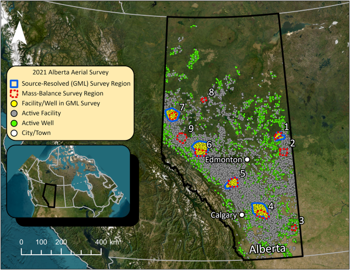
Two independent aerial surveys using unique measurement technologies were performed to quantify oil and gas methane emissions in Alberta during 2021. The primary, source-resolved survey deployed Bridger Photonics Inc.’s Gas Mapping LiDAR™ (GML) technology16,17 to complete high spatial resolution (~1–2 m) measurements of upstream oil and gas facilities and wells (i.e., sites) within five representative sub-regions of Alberta as detailed below. This survey was led by the Energy and Emissions Research Laboratory (EERL) and was specifically designed to enable creation of a hybrid, source-resolved, measurement-based methane inventory for Alberta following the detailed methodology described by Johnson et al.20. A parallel region-level survey, led by the Environmental Defense Fund (EDF), deployed an aircraft from Scientific Aviation to complete aerial mass-balance flights21 around nine geographically distinct conventional oil and gas production regions within Alberta. These flights enabled an independent estimate of total methane emissions for comparison with the total obtained from the source-resolved inventory. Finally, a third independent total emissions estimate for comparison was derived from the satellite measurements of Shen et al.22 as further detailed below.
Figure 1 shows a map of Alberta identifying all facilities and wells that were active during one or more months of the survey period, September–November 2021. Facilities and wells were deemed active based on volumetric reporting in the public Petrinex database24 (see online supplementary information (SI) for further details and ref. 25 for a glossary of oil and gas terminology) and are coloured according to their inclusion in the source-resolved survey as summarized in the legend. Blue and dashed red polygons in the figure represent the five and nine regions surveyed by Bridger Photonics and Scientific Aviation, respectively. As further described in the Methods section below and in Section S1 of the SI, the facilities and wells within these regions encompassed the diversity of upstream conventional oil and gas activities in Alberta, while excluding “unconventional” mined and in situ oil sands, which were not considered.
Provincial upstream oil and gas sector methane inventory
The provincial methane inventory for the upstream oil and gas sector derived using the present source-level aerial measurement data is summarized in Fig. 2. As discussed below (and further detailed in SI Section S2 and Johnson et al.20), the derived provincial inventory is parsed into four components: the measured source inventory (blue), unmeasured non-pneumatic source inventory (orange), and unmeasured source inventory for pneumatic instruments (light gray) and pneumatic pumps (dark gray). The derived 2021 Alberta conventional upstream oil and gas methane inventory is 1337 kt/y with a 95% equal tail confidence interval (95% CI; the range defined by the 2.5th and 97.5th percentile of the data, derived from the measured source inventory only) of 1142–1669 kt/y. This represents a stark 147% (126–184%) increase over the corresponding upstream emissions (S. Smyth, personal communication, April 19, 2023) from the official inventory from Environment and Climate Change Canada’s National Inventory Report7 (ECCC) of 909 kt/y. Moreover, the 1014 kt/y contribution from measured sources on their own exceeds the total of the most recent federal estimate by more than 10%.
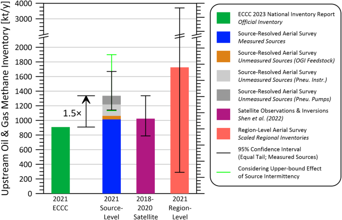
The observed discrepancy between the official and hybrid top-down/bottom-up, measurement-based inventories is not novel to the province of Alberta nor the measurement year. Significant discrepancies between aerial/satellite measured/estimated inventories and official bottom-up inventories or industry-reported emissions have been observed previously in sub-regions of Alberta in 201612, the neighbouring province of British Columbia (BC) in 201918 and 202120, and numerous basins in the U.S.22,26,27. However, the present inventory for Alberta and the 2021 inventory for BC20 are unique in that approximately 76 and 78% of the inventories, respectively, are based on direct measurements at the source level. This permits robust characterization of measurement uncertainties and consideration of sample size effects20 and, following manual attribution of individual sources to specific equipment types, enables a detailed breakdown of the inventory by source (see below and Johnson et al.28).
Figure 2 also shows how the present source-level inventory aligns with estimates derived from satellite data by Shen et al.22. Via Bayesian inverse methods, Shen et al.22 combined methane retrieval data from the Tropospheric Monitoring Instrument (TROPOMI) during May 2018 to February 2020, sector-resolved prior anthropogenic methane emissions, and chemical transport models to obtain a gridded methane emissions inventory for the continental U.S.A. and portions of Canada. Posterior Monte Carlo data provided by the authors were used to aggregate gridded data to the province of Alberta to estimate the provincial methane emissions inventory for the conventional upstream sector; these data imply annual emissions of 1024 kt/y with a 95% CI of 788–1337 kt/y. Notwithstanding the differing inventory periods and likely underestimation of satellite inventory uncertainties (see below), error bars for this satellite-based estimate significantly overlap with those of the present study suggesting that there is no statistically significant difference between the two inventory totals. Moreover, the prior emissions used to regularize satellite observations in the analysis of Shen et al.22 were sourced from Scarpelli et al.29 who used 2018 data from ECCC’s National Inventory Report to derive gridded methane emissions by sector for the country. This is the same source data (albeit in a different year) that underestimates the present inventory by a factor of 1.5. Thus, assuming limited TROPOMI observations (which are regularized to purposely avoid over-fitting at the cost of biasing emissions estimates towards the prior) at northern latitudes are insufficient to overpower Scarpelli et al.’s29 data as a prior, it is reasonable to expect that Shen et al.’s22 inventory should be biased low, which potentially explains the differences between the nominal inventory totals plotted in the figure. Further negative bias arises due to the exclusion of satellite grid cells (49 total with a combined area of approximately 25,300 km2) containing in situ or surface mined oil sands facilities and upgraders when calculating the Shen et al.22 total. While necessary to enable comparison of conventional oil and gas inventory totals, this inherently excludes some co-located conventional facilities and wells that would be expected to account for 1.2% of the inventory based on present measurements. In addition to the identified sources of negative bias, the plotted uncertainties in the satellite-derived provincial inventory are likely to be conservatively small since Monte Carlo-perturbation of prior emissions were limited to +50% from the Scarpelli et al.29 (which is insufficient to encompass the final inventory total observed in the present study) and did not consider uncertainty in sectorial partitioning. This propensity for underestimation is further supported by the regional inventory comparison shown in Figure S5 of the SI, where in two of five regions the satellite inventory estimate is less than the measured-source component of the source-resolved inventory on its own.
The rightmost bar in Fig. 2 shows a derived emissions inventory for Alberta from the parallel region-level aerial survey (see SI Section S5). Referring to the SI, regional emission rate data were regressed to obtain energy-based methane emission factors for produced gas, condensate, (light) crude oil, and heavy oil, which were multiplied by raw provincial production to estimate the 2021 provincial inventory. The nominal result was 1726 kt/y with an estimated 95% confidence interval of 290–3700 kt/y considering measurement and regression errors. Noting the break in the vertical axis of Fig. 2, this analysis highlights the challenge of scaling region-level emissions data to a larger jurisdiction when regional uncertainties are high (see Table S10). Nevertheless, the nominal provincial total aligns with the upper bound of the present source-resolved, hybrid inventory. Thus, all three independent inventory estimates agree within uncertainty limits and support the key conclusion that actual upstream oil and gas sector methane emissions in Alberta are substantially higher than official inventory estimates.
Breakdown of inventory by source
Aggregating the nominal magnitudes of measured and bottom-up sources from the present hybrid inventory into fifteen unique emitter categories reveals the true breakdown of sources driving methane emissions in Alberta (Fig. 3b). This result is contrasted with the breakdown gleaned from the most recent National Inventory Report7 (NIR) of Environment and Climate Change Canada (ECCC) (Fig. 3a), revealing important gaps in the current reporting framework. In addition to the 1.5× difference in total emissions magnitude, the stark differences in source breakdowns can be expected to hinder mitigation policy and complicate ongoing development of regulations to meet 2030 reduction targets. Most notably, the official NIR estimate is constrained by the granularity of available bottom-up reporting and emission factors, such that more than half of the inventory are coarsely attributed to “reported venting” and “equipment leaks” without further detail (see striped slices of Fig. 3a). The former reflects an aggregation of vented gas volumes reported by industry to the Alberta Energy Regulator (AER) through the Petrinex24 reporting system, and adjusted using reporting to the OneStop30 system. Notwithstanding that these volumes represent a coarse combination of sources that may include venting from tanks, compressor seals, or other sources, site-total volumes below 500 m3/day of whole gas do not have to be measured and instead are typically only estimated using a predetermined gas-oil-ratio (GOR) and measured volume of produced oil31. Worse, site-level measurement studies11,32,33 show that reported vent volumes tend to markedly underestimate measured totals. Similarly, the equipment leaks category in the NIR is an aggregate estimate of fugitive sources based on average counts per facility and emission factors from Clearstone34.
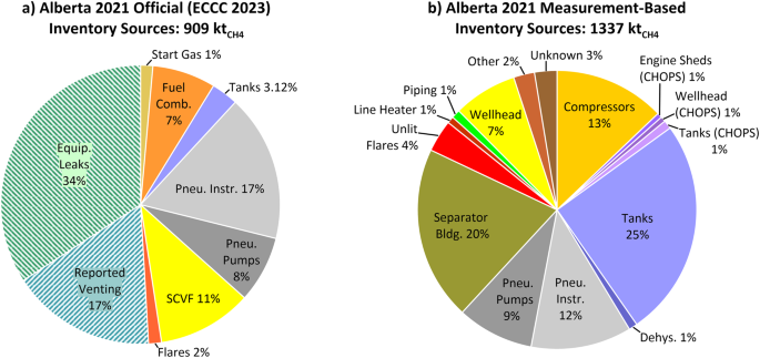
Among directly comparable sources, the relative contribution from wellhead emissions (i.e., surface casing vent flows (SCVF) in Fig. 3a) appears to be overestimated in the ECCC inventory by approximately a factor of 1.5, although the absolute magnitudes are effectively equivalent. ECCC35 estimates surface casing vent totals from well-specific emission factors that combine a gas composition map derived by Tyner and Johnson36 and reported and measured events tabulated in the AER’s Vent Flow and Gas Migration Report37 (i.e., onset and resolution dates and estimated flow rate). Although these latter data are notably incomplete – approximately 28% of serious and 66% of all gas vent flows since 2016 (inclusive) do not have a reported resolution as of writing and approximately 30% of all events do not have a reported flow rate – the observed agreement suggests that the missing data are likely small on an emission rate basis. More importantly, this result highlights that bottom-up inventories using direct, source-level measurements can indeed match source-resolved top-down measurements.
By contrast, the relative contribution of tank emissions (which are parsed into CHOPS – cold heavy oil production with sand – and non-CHOPS activities in Fig. 3b) appear to be underestimated by a factor of approximately 8.4× (26.3% vs. 3.1%) in the official inventory. Even if all reported venting in the NIR breakdown were attributed to tanks, absolute tank emissions of 352 kt/y in the present measurement-based inventory would still be underestimated by one half. This discrepancy is consistent with the fact that reported tank venting in Alberta is generally not measured and instead is most often based on engineering estimates and models of flashing losses from infrequently measured or modelled gas in solution (GIS)31. Indeed, Rutherford38 suggested that underestimation of unintentional venting from tanks is one of the biggest reasons for discrepancies between the official inventory and measurements in the U.S. On a positive note, total CHOPS-related emissions from tanks, wellheads, and engine sheds are markedly lower than parallel measurements in the neighbouring province of Saskatchewan32. Ground studies could help identify particular reasons for this discrepancy, however the primary reason is surely the eighteen times lower regulated venting limits for heavy oil facilities in Alberta versus Saskatchewan15,39.
The ECCC inventory does not include a specific category for unlit flares (50 kt/y in the present inventory) but does estimate flare-related methane emissions based on total reported flare volumes in Petrinex, assuming a location-dependent methane content for flared gas and a 98% combustion efficiency35. Notwithstanding the potential inaccuracy of a 98% combustion efficiency for flares of complicated gas compositions in potentially turbulent crosswinds (see, for example, refs. 40,41,42), this inherently assumes flares are always lit. Consistent with recent studies18,28,43,44,45, the present source-level aerial measurements detected multiple unlit flares but only rarely detected methane from lit flares. Overall, methane emissions from unlit flares were >40× that of detected inefficient lit flares in the present study. As a thought experiment, combining flare volumes reported to Petrinex in 2021 (1.15 billion m3) and an assumed methane content of flared gas were 85.2% by volume20, an effective flare efficiency of approximately 92% would be required to match the measured total methane from lit and unlit flares in the present survey; this is consistent with recently estimated average effective flare efficiencies of 91.1% (95% CI: 90.2–91.8%) in three U.S. basins46. More importantly, although unlit flares are just 3.7% of the present measurement-based inventory, they represent a mitigation potential of approximately 50 kt/y of methane that in principle should be one of the easiest and lowest cost sources to mitigate. However, given that at least 65% of the inventory contribution from unlit flares is from single-well facilities and well sites that are unlikely to be crewed, this mitigation is unlikely to be achieved without a commitment to ongoing monitoring and verification.
The large (20%) contribution of emissions associated with separators in the present inventory was somewhat unexpected, although these sources were recently found to emit 9% of methane emissions in neighboring BC20. Ground investigations in BC28 suggested that separator-related emissions may represent a combination of possible sources including abnormally operating pneumatic instruments and/or pumps, methane slip in catalytic heaters, and failing/emitting pressure relief valves and regulators. At crude oil wells and batteries specifically (responsible for just under one-half of aerially detected separator emissions), it is possible that emitted methane may also include intentional venting of associated gas in place of other techniques like capturing co-produced gas or combustion. Further ground analyses of separator emissions in Alberta would be helpful to discern the root causes of these aerially detected emissions and associated opportunities for mitigation.
Overall, the distribution of sources in Fig. 3b suggests that vented sources dominate conventional upstream oil and gas sector methane emissions. Assuming all non-CHOPS-related wellhead sources, all piping, and all other and unknown sources can be classed as fugitive leaks; separator emissions are split equally between vented and fugitive sources; and compressor emissions are dominated by methane slip in the exhaust28; approximately 63% of methane in the inventory could be categorized as known vent sources (e.g., uncontrolled tanks, pneumatic equipment, dehydrators, CHOPS-related venting, unlit flares or vent stacks), approximately 14% as combustion-related methane slip, and approximately 24% as fugitive leaks. From a mitigation perspective, this is potentially encouraging since known vent sources in principle should be easier to address and their mitigation is more likely to result in sustained reductions in emissions. However, the significant 5.5× difference between reported venting levels and the implied venting totals in the present inventory (152 kt/y vs. 840 kt/y) highlights the need for the verification component of MRV efforts if emissions are to be accurately identified, tracked, and reduced.
Methane emissions intensities
To enable objective comparison of the present methane inventory with other jurisdictions, it is useful to derive methane emissions intensities of marketed products. For natural gas, one useful metric is the Natural Gas Sustainability Initiative’s47 (NGSI) emissions intensity (sometimes called leakage rate27 or a loss rate, but hereinafter called NGSI methane intensity), which allocates a portion of total methane emissions to natural gas production on a produced energy-basis and calculates a characteristic leakage rate (in percent) by comparing to the amount of methane in marketed natural gas. As detailed in SI Section S3 and plotted in Fig. 4a, the present inventory results suggest the NGSI methane intensity for the conventional upstream sector in Alberta in 2021 was 1.58% (95% CI: 1.35–1.97%). After adding in downstream emissions estimated by ECCC7, the total conventional sector NGSI methane intensity for 2021 was estimated to be 1.65% (95% CI: 1.42–2.04%). As shown in the figure, this total conventional sector NGSI methane intensity is closely aligned with nominal 2018/19 NGSI methane intensities of 1.27%–1.63% estimated20 from satellite measurements27 in the U.S. Appalachia, Bakken, Eagle Ford, and Permian basins, and much less than the 4.40% (95% CI: 3.21–5.58) estimated for the Anadarko basin. By contrast, the 2021 NGSI intensity for Alberta is approximately four times that of the neighboring province of BC20 – upstream sector: 0.38% (95% CI: 0.33–0.44%) and total sector: 0.42% (95% CI: 0.36–0.48%). Although BC is largely a gas-producing province (90% of total production on an energy-basis), conventional operations in Alberta (i.e., excluding mined and in situ oil sands production) are comparably gas-dominant at 70% of total production on an energy-basis. Contrasting the source breakdown presented above for Alberta and that presented by Johnson et al.20 for BC highlights much greater relative methane contributions of tanks and other non-compressor sources in Alberta, which further underscores the opportunities for mitigation.
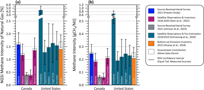
The methane intensity of marketed hydrocarbon products, defined as the total mass of emitted methane per unit of total delivered energy in gCH4/MJ, is a second important metric for assessing environmental impacts. Although closely related to the NGSI methane intensity, the two metrics differ due to jurisdiction-dependent differences in methane contents of produced gas and energy contents of marketed gas and oil. In the present work, the methane content of produced gas was fixed to 85.2% for consistency with Johnson et al.20 and energy contents of produced hydrocarbons were taken either from the Canada Energy Regulator48 or the U.S. Energy Information Administration49. As detailed in Section S3, the present hybrid inventory suggests that the 2021 methane intensity of energy products from Alberta’s total conventional sector was 0.257 gCH4/MJ (95% CI: 0.221–0.317). Referring to Fig. 4b, this matches within uncertainty a western Canadian estimate of 0.222 gCH4/MJ (0.168–0.285) derived from satellite measurements of Shen et al.22, and equals a 2015 United States estimate of 0.252 gCH4/MJ (0.220–0.293) based on the inventory of Alvarez et al.26. However, this intensity is again substantially higher than the methane intensity of 0.065 gCH4/MJ (0.057–0.075) for total sector energy products from BC in 202120. Key reasons for this difference include stronger regulations and enforcement in BC, noting that BC requires three times per year leak detection and repair (LDAR) surveys at most facilities that include direct measurement of detected leaks50, which are further backed by transparent publishing of operator-specific LDAR data to track performance51. Additional factors likely include geologic differences in amounts of energy produced per facility and potential differences in methane intensities by general facility type (e.g., predominantly gas or oil facilities, multi-well vs. single-well facilities, etc.). As discussed in the following section, there can also be significant differences in environmental performance among operators.
Operator performance
To explore this further, Fig. 5 compares measured-source methane intensities (i.e., considering only the measured-source portion of the inventory) of companies operating three of the most common facility subtypes in Alberta: crude oil single-well batteries (subtype 311), crude-oil multi-well batteries (subtypes 321 and 322), and gas single-well batteries (subtype 351). These operator-specific intensities were calculated by running the complete measured source inventory protocol (including the analysis of intermittency effects described in SI Section S4) on the subsets of facility types operated by each company. Data are only shown where the sample size of an operator’s assets was sufficient to complete the mirror-match bootstrap analysis52,53 to enable a robust quantification of uncertainties.
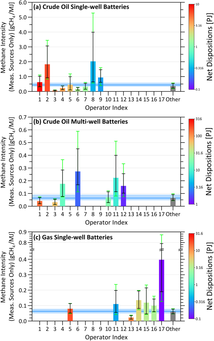
Noting the different scales on the vertical axes of Fig. 5a and b, the first important observation is that single-well oil facilities have approximately order of magnitude higher methane intensities than multi-well oil facilities. This has several potential implications for regulation and mitigation, but above all shows how smaller single-well sites can disproportionately increase methane intensities of an operator and cannot be overlooked in the quest to reduce methane emissions. While detailed analysis of these trends is beyond the scope of this paper, reasons for this difference would include facility age (where multi-well facilities are more common for new development) and the likelihood of better mitigation infrastructure at multi-well sites (e.g., air-driven pneumatic equipment, controlled tanks, on-site combustors, etc.). Second, by restricting the analysis to sets of identical facility subtypes, it is possible to objectively compare real-world, independently measured methane intensities of different operators. These data show that many operators are statistically smaller or larger emitters than the average and that differences in methane intensities among operators of the same facility types can exceed an order of magnitude. Referring to Fig. 5a, operators 2 and 3 produce similar, large amounts of energy (net dispositions of approximately 6 PJ) at their crude oil single-well batteries but the measured-source methane intensity of operator 2 is approximately 31 times larger than operator 3 (1.829 vs. 0.059 gCH4/MJ). In terms of opportunity, Fig. 5 highlights achievable, independently verified methane intensities that all operators can strive toward; see, for example, operator 3 in Fig. 5a and b and operator 13 in Fig. 5c, who are producing large amounts of resources with notably lower methane intensities than many of their peers.
Finally, Fig. 5 demonstrates how high-sensitivity source-resolved measurements combined with careful analysis and rigorous consideration of uncertainties20 can be used to independently quantify methane intensities of individual companies. This is a key goal of international initiatives such as the oil and gas methane partnership (OGMP 2.0)23 as well as several private gas certification programs. The value and importance of third-party verification in these efforts is also difficult to overstate. For one of the anonymized operators in Fig. 5, the measured-source methane intensity (excluding any additional contributions from unmeasured sources and pneumatics) is 21 times greater than what is reported in their public Environmental Social Governance (ESG) report. Certainly, it is possible that much lower intensities at other producing facilities in their portfolio could lead to an overall intensity as they report. However, given the discrepancy in Fig. 2 between official inventories and top-down measurements like the present source-resolved aerial survey, it is also possible that self-reported emissions estimates used in ESG reporting are similarly underestimated. Most importantly, the disparity in measured methane intensities among operators highlights a key challenge in achieving the sector-wide methane reductions needed to meet climate targets. Success will require a collective commitment. While a few operators are clearly leading the way, their efforts risk being overshadowed by the emissions profiles of some others. This underscores the critical importance of third-party verification as part of emerging monitoring, reporting, and verification (MRV) frameworks.
Methods
Source-resolved aerial survey
The source-resolved aerial survey flights were completed during September 3 to November 10, 2021, using Bridger Photonics’ GML technology. Referring to additional detail in the literature16,17,54,55, the GML is an aircraft-mounted active optical sensor capable of detecting and quantifying methane abundance at spatial resolutions of approximately 1–2 m when flown at typical altitudes of 175 m above ground level (AGL). At such altitudes, the swath width of the optical sensor is approximately 100 m, which is sufficient to fully scan and quantify methane emitters at small oil and gas facilities (e.g., single-well batteries) with a single pass of the aircraft; for larger facilities, multiple passes are necessary. The measurement protocol entailed an initial flight (with one or more passes) over each site, preliminarily analysis of the initial data from the pass(es) over that site, and then subsequent re-flight(s) of all sources detected during the initial flight usually 1–11 (mean of 3.58 and median of 3) days later. This process enabled insights into the persistence of each detected source and reduces quantification error through the averaging of detections over flight passes and measurement days20,28.
As detailed in Section S1.2 of the SI, the present survey was planned by EERL during spring 2021 using available January to March 2021 volumetric reporting data from the Petrinex database24 to identify active facilities and wells within the province. Five survey regions were defined whose combined distribution of facility subtypes (e.g., crude oil single-well battery, sweet gas plant, gas gathering system) and well-bore fluids (e.g., crude oil, crude bitumen, and gas) were broadly representative of the province as a whole. Within each of these regions, all facilities that were active at the time of planning were included in the aerial survey subject to the availability of sufficient quality satellite imagery, which was used to manually bound the facilities’ footprints and create geo-located shapefiles to guide the plane. The remaining project budget was deployed to survey as many off-site well pads as possible. In total, 3454 geographically distinct sites were surveyed, which at the time of the survey (September 3 to November 10, 2021) included 3317 active facilities and 5205 unique active wellheads, representing approximately 17.6% and 3.7% of provincial counts, respectively. An additional 152 (5.1%) shut-in facilities and 387 (3.3%) shut-in wellheads were also included in the sample and separately analyzed as further detailed in the SI.
Source attribution
During the aerial survey, Bridger detected 2087 unique methane sources. Reported GML data included high-resolution, geolocated, visual imagery for each surveyed site/polygon. Combined with facility plot plans obtained from the Alberta Energy Regulator, these data enabled the manual attribution of detected sources to specific equipment at the building scale (e.g., compressor buildings, separators, dehydrators, tanks, unlit flares, etc.). Additional provided data for each flight pass included the estimated local wind speed from Meteoblue (http://www.meteoblue.com/) and aircraft altitude; combined with the continuous probability of detection function for Bridger’s GML derived from parallel controlled release studies19, methane sources of 1.6 and 3.2 kg/h were detectable with 50% and 90% probability at the median wind speed and aircraft altitude of the present survey. Quantification errors (95% CI) for a single observation were approximately –69/ + 113%19, which reduced to an average value of –42/ + 48% when averaging detections over available flight passes and measurement days for each source.
Source-resolved, hybrid measurement-based inventory
The detected source data were then used to develop a measurement-based, hybrid top-down/bottom-up provincial inventory following the method of Johnson et al.20. Firstly, a provincial inventory for measured/measurable sources (those detected/detectable by Bridger’s GML) was derived from the survey data. Referring to the method of Johnson et al.20 and SI section S2, the inventory was computed using a stratified sampling approach that first parsed detections by facility type or well-bore fluid to produce separate emissions estimates for each stratum. A Monte Carlo algorithm perturbed successfully detected/quantified emissions at the pass-level according to the quantification error model for Bridger’s GML19 while also perturbing any “missed” detections (i.e., instances where a source at a specific location is detected during one or more flight passes but not in others, whether due to source intermittency or probabilistic detection) via a Bayesian analysis. This Bayesian analysis leveraged the continuous probability of detection function19 at the time of the miss and the prior knowledge that a source at this location had been detected. A mirror-match bootstrap analysis52,53, nested within the MC algorithm, scaled flight pass- and measurement day-averaged detected emissions to the province; fully considering sample size effects and the finite populations of each stratum.
This measured inventory was combined with a provincial inventory of unmeasured sources, derived through a separate MC simulation20. This supplemental analysis used the specific measurement conditions during the survey to simulate flights over facilities/wells with sources near or below the detection limit of Bridger’s GML from prior studies. These bottom-up source data included measured or estimated source rates for non-pneumatics from a 2017 ground survey in Alberta by Clearstone Engineering34, pneumatic counts from the same survey34, and pneumatic emission factors from the Alberta Energy Regulator56, and are the same data that underpin current official inventory estimates. A key distinction of this hybrid, top-down/bottom-up, measurement-based protocol is that bottom-up data only contribute to the final inventory as sources that would not have been seen in any measurement pass. As such, more than three-quarters of methane in the present inventory is directly measured. As further detailed by Johnson et al.20, this procedure ultimately provides stratum-specific emission factors that are applied to the population of sites in the province to yield the unmeasured portion of the total provincial inventory parsed by pneumatic instruments, pneumatic pumps, and non-pneumatics.
Region-level aerial survey
Mass-balance measurements to estimate total emissions from the nine regions shown in Fig. 1 were completed by Scientific Aviation under the direction of EDF during September 29 to November 6, 2021. This simultaneous survey (bounded by the measurement dates of the source-resolved survey) was implemented to provide a secondary estimate of the provincial inventory using an alternative method. Briefly, referring to additional detail in the literature21, light aircraft-mounted instrumentation tracks local methane concentration and wind speed/direction during flight laps surrounding a geographical region of interest. These data provide a local flux of methane out of the measurement region, which, via Gauss’ divergence theorem, is used to estimate methane emissions within the measurement region. Given the regional nature of this measurement, detected methane flux is a function of sources and sinks across numerous potential sectors. Detected methane flux was ultimately apportioned to upstream oil and gas activity by correcting for non-oil and gas anthropogenic and wetland methane emissions using openly available data29,57. This procedure and an associated uncertainty analysis is detailed in SI Section S5.1. Computed emission rates for the nine regions were scaled to estimate a provincial inventory as detailed in SI Section S5.3 and presented above alongside results of the source-resolved inventory.
Data availability
Data to replicate Fig. 2 through Fig. 5 in the main text and Figures S2 through S5 in the supplementary information, as well as Supplementary Tables of results can be accessed via the Carleton University dataverse at https://doi.org/10.5683/SP3/8K88G6. Anonymized detected emissions for each detected source in the aerial survey are also included.

Refer also to:
2021: New study: Canada overlooking (intentionally?) industry’s methane leaks.
2019: The Leaks that threaten the clean image of natural gas
2016: Colorado regulators find leaking methane and VOC violations at 10 companies, Encana included
2013: Methane Leaks from Fracking are Much Worse than We Thought
2012: Independent study finds significant fault line methane leaks near PA natural gas operations
2012: MIT Frackademics, The ‘entire natural gas system’ is driving methane emissions — MIT study
2012: Fracking blamed for methane releases
2012: Fugitive Methane Caught in the Act of Raising GHG
2011: Inspectors found leaks at shale wells, government report says
2011: