Comments to the Tyee article, including excellent one by Mr. Koop of BC Tap Water Alliance:
The photo at the beginning of this article, showing three water pits, has been published numerous times, but never identified. I know this place. This is Shell Canada Limited’s Saturn 1 Gas Plant (legal identifier, 3-28-80-20 W6M), located 29 kilometres due west, as the crow flies, from the intersection of Braden Road and Highway 97 (near the town of Farmington). It is a bizarre looking photo and well represents Shell’s enormous countryside seismic and water poisoned fracking footprints in the remote lower western Montney.
The BC Liberals are responsible for our present-day heinous plight in northeast BC, with all the secret Land Sales and the attached legal contract liabilities the public has inherited and shoved down its collective throats.
The BC Liberals also failed to impose strategic cumulative environmental effects study conditions for each and every fracking development, the same policy failures coincidentally and repeatedly exhibited in the other western fracking provinces, the very same inexcusable position endorsed by the Canada Energy Regulator (the former National Energy Board).
And the present NDP government has continued to endorse these and related curses, including the out-of-control, industry-funded, industry-populated, and conflict-of-interest-filled, OGC.
This is a huge fracking mess, an outcome which is not going to end nicely.
Thank goodness for responsible people like Allan Chapman, who had the guts to expose the research and defy the shameless and arrogant profiteering bullies.
The B.C. Tap Water Alliance has continuously called for a fracking ban in BC for just over eleven years now, as many jurisdictions in the world have increasingly and wisely adopted.
As bad as these quakes could be and as much as I don’t like the idea of them, or the cause, the other side affect of fracking that gets more of my attention is the damage to and poisoning of underground water sources. That this is allowed to happen is beyond my comprehension. For this reason I would stop fracking except for areas where it can be PROVEN this won’t happen. For good measure we should put the areas susceptible to fracking induced earthquakes on the list too.
Change BC Fracking or Expect Damaging Earthquakes: Report, The new warning comes from a former senior scientist with the province’s oil and gas commission by Andrew Nikiforuk May 27, 2021, TheTyee.ca
In 2018, one magnitude 4.6 tremor tied to fracking even rattled buildings in Fort St. John and stopped construction on the Site C dam. It was followed by two strong aftershocks.
Now, a comprehensive new scientific study warns that stress changes caused by the technology could trigger a magnitude 5 earthquake or greater in the region, resulting in significant damage to dams, bridges, pipelines and cities if major regulatory and policy reforms aren’t made soon.
Allan Chapman, the author of the paper served as a senior geoscientist for B.C.’s Oil and Gas Commission and as its first hydrologist from 2010 to 2017. Prior to working for the commission, he directed the Ministry of Environment’s River Forecast Centre, which forecast floods and droughts.
Chapman, now an independent geoscientist, said that he felt compelled to write the paper because researchers have concluded that fracking “induced earthquakes don’t have an upper limit” in terms of magnitude.
In addition, “there is a clear and present public safety and infrastructure risk that remains unaddressed by the regulator and the B.C. government.”
B.C.’s Oil and Gas Commission rejected Chapman’s conclusions in a statement to The Tyee, saying his study contained “speculation.”
Recent events in China’s Sichuan province prove that fracking can trigger large and destructive earthquakes.
Gas drilling operations there generated shallow earthquakes between magnitude 5.3 to 5.7 in recent years that resulted in deaths, extensive property damage and angry protests by local citizens.
Chapman says the commission’s current system for managing tremors, known as a “traffic light protocol,” can’t prevent larger magnitude earthquakes because it ignores how cumulative fracking over time destabilizes shale formations with high pressures and increases seismic risk.
“To protect people and infrastructure, we are going to have to avoid fracking in some areas,” he told The Tyee.
Public infrastructure placed at risk by fracking now includes “the communities of Dawson Creek, Fort St. John, Taylor, Hudson’s Hope, Upper Halfway (Halfway River First Nation) and possibly others, and infrastructure such as the WAC Bennett, Peace Canyon and Site C dams, community water supply and treatment systems, the Taylor Gas Plant, the Taylor Bridge crossing of the Peace River, numerous earthen water storage dams, and others,” said the paper.
The Taylor Bridge, for example, was built in 1960 prior to the fracking boom, which has changed both seismic patterns and risks in the region.
The bridge, now deteriorating, is responsible for transporting millions of dollars of merchandise, food and fuel every hour between Fort St. John and Dawson Creek in the province’s Peace Region.
More fracking, more tremors
Given that 60 to 70 per cent of earthquakes greater than magnitude 3 are already caused by hydraulic fracturing in the giant Montney shale formation that straddles B.C.’s border with Alberta, Chapman forecasts more and larger tremors in the future.
One factor, he says, is accelerated drilling to serve Shell’s LNG Canada project in Kitimat, B.C.
Another factor he cites is that the injecting of fracking fluid deep into the ground appears to have a cumulative effect.
Chapman’s study documents how fracking-induced earthquakes “increase in both frequency and magnitude in relation to frack fluid injection volumes, and that there appears to be a cumulative development effect where prior frack fluid injection possibly resets the seismic potential in certain tectonic environments to allow for eased earthquake initiation related to future lower-volume injections.”
As a consequence, writes Chapman, “the future in the Montney is not if earthquakes greater in magnitude than 5 will occur, but when, with that occurrence possibly without any precursor warning.”
Chapman’s study, published in the Journal of Geoscience and Environmental Protection this week, also sheds a light on companies triggering the earthquakes as well as the inadequacy of current mitigation measures and legislation.
Hydraulic fracturing blasts large volumes of pressurized water, sand and chemicals deep into concrete-like shale formations one to two kilometres in the Earth.
That force shatters rock underground with a network of fractures so that methane, oil or natural gas liquids can be released.
It can also connect to natural faults triggering swarms of earthquakes.
‘Speculation’ says Oil and Gas Commission
In a statement to The Tyee, the Oil and Gas Commission outright rejected Chapman’s analysis. “Our geological and engineering experts have concluded it is based on a number of unproven assumptions or incomplete consideration of the factors cited.”
The commission added that the paper didn’t look at Montney’s structural setting, fault types and local rock stress.
It added: “Speculation such as is in this paper requires expertise in seismology, fracturing, reservoir engineering, ground motion and critical infrastructure. All of the commission’s research and changes to regulatory framework are vetted through partner organizations that retain full-time, trained seismologists.”
The commission did not specifically answer questions from The Tyee on the adequacy of the traffic light protocol in the Montney.
The commission is entirely funded by industry.
Unlike most papers on fracking and earthquakes, Chapman’s study is one of the first to name companies responsible for large tremors in northeastern B.C.
The scientist said he did so for reasons of accountability. “It is in the public interest for their names to be known.”
Since 2012, 77 per cent of the earthquakes triggered by fracking in the Montney have been caused by three companies: Petronas, Tourmaline Oil and Ovintiv (formerly Encana).
Petronas, a Malaysian company, holds the record for most quakes. Its fracking activities are associated with 78 per cent of the earthquakes in the northern Montney and almost one-half the earthquakes in the entire Montney over the 2013 to 2019 period.
Researchers estimate that one out of 150 wells fracked wells in Western Canada will trigger a magnitude 3 tremor.
But Chapman found that that 1.7 per cent of fracked wells (about one out of 60 wells) in B.C. are associated with earthquakes with magnitudes of 3 and up. That’s nearly double the rate of earlier research.
The Montney shale formation, which contains both methane and liquid condensates, sits under a vast area of timber, farmland and wilderness on 26,600 square kilometres of Treaty 8 land extending from south of the community of Dawson Creek to 200 kilometres northwest of the community of Fort St. John.
Between 2012 and 2019, nearly a dozen companies have fracked 2,865 wells with 39 million cubic metres of water in the Montney.
The volume of pressurized water used per well has increased steadily in recent years from an average of 7,077 cubic metres per well in 2012 to 22,054 cubic metres per well in 2019.
Many operators including Ovintiv, Petronas and CNRL have fracked wells using more than 30,000 cubic metres per well. ConocoPhillips stands out for using 83,000 cubic metres per well for 13 wells in 2019.
Beginning in 2008, industry started to trigger “felt” earthquakes greater than magnitude 3, raising concerns throughout the region.
B.C. and Alberta regulators initially denied the industry could cause earthquakes that significant and then called them “anomalous” or minimized their shaking motions to a truck driving by.
As industry injected more volumes of water into the ground to fracture gas-bearing rock, the frequency of earthquakes jumped from an average of 1.6 magnitude 3 quakes a year to almost 6.9 magnitude 3 tremors by 2019.
Petronas led with the highest earthquake rate: “39 per cent of its fracked wells are associated with earthquakes,” followed by Tourmaline Oil with 29 per cent and Ovintiv at nine per cent.
Effects of repeated injects build up: study
Cumulative injection has played a dramatic role in triggering many tremors in the Montney region, said Chapman.
In November 2018, for example, CNRL set off three tremors by injecting nearly 15,000 cubic metres of water in two hydraulically fracked wells that resulted in three quakes, including a magnitude 4.6 tremor that rattled the Site C dam and shut down construction operations for a day.
“However, this seems to be the proverbial straw that broke the camel’s back,” noted Chapman in the study.
Prior to the three headline-making tremors, four operators within a five kilometre radius of the seismic events had injected 1.72 million cubic metres of water into 109 fracked wells over a period of three years.
“As many as 29 per cent of the Montney earthquakes are associated with hydraulic fracturing conducted by multiple operators over antecedent time periods of one year and longer, in some cases as many as four operators,” noted the report.
Various studies by both U.S. and Canadian researchers have demonstrated that stresses from frack operations can migrate distances of over 10 kilometres through natural fractures in the rock and destabilize rock pressure for long periods of time, making it impossible for industry or regulators to predict when earthquakes might occur from fracking.
Research commissioned by B.C.’s Oil and Gas Commission acknowledges that “only small fluid pressure increases are sufficient to cause specific sets of fractures and faults to become critically stressed,” in the southern Montney.
“Once you have primed an area and started the triggering of earthquakes, it doesn’t take much more injection to keep the seismicity going,” said Gail Atkinson, one of Canada’s top seismic hazard researchers.
The scientist described Chapman’s study as “excellent work” and an important contribution to the research.
Atkinson, who held an Industrial Research Chair in Induced Seismicity at Ontario’s Western University until her retirement in 2020, added that Chapman’s findings are consistent with what she’s found in her own studies on fracking and earthquakes in Western Canada’s oil and gas fields. “Some areas, once you get them going seismically are much harder to turn off than on.”
Drilling by Petronas in 2015 provides an example of the importance of cumulative impacts in Chapman’s study.
In August of that year, the company’s fracking generated a magnitude 4.6 earthquake in the north Montney. “For this event, Petronas was the sole operator, injecting 67,625 cubic metres of frack fluid into three wells in the week before the earthquake,” noted the science paper.
But over a two-year period prior to the event, Petronas had injected a total of 275,000 cubic metres of frack fluid into the ground.
‘Traffic light protocol’ won’t brake a big quake: experts
In 2015, B.C.’s Oil and Gas Commission introduced the traffic light protocol in an attempt to control damaging earthquakes.
According to the protocol, if a company causes an earthquake of magnitude 4 or greater within three kilometres of its fracked well, it must shut down its operations — a red light event.
The protocol in the southern Montney uses magnitude 3 as its red light for stopping fracking. (In contrast, the United Kingdom set magnitude 0.5 as its red light.)
Many researchers including Atkinson have questioned the efficacy of the protocol, because many induced earthquakes don’t produce smaller “yellow light” warning events.
Fracking can also cause large earthquakes months or even years after a well has been fracked.
And local ground-shaking motions can be severe at much smaller magnitudes.
Many magnitude 3 earthquakes in B.C. have been triggered by wells nearly six kilometres from the epicentre.
“Only 26 per cent of the trigger wells are within three kilometres of the earthquake,” reported Chapman. However, some of the larger observed triggering distances may be a result of significant uncertainty in earthquake locations.
B.C.’s traffic light protocol has been inconsistently enforced and is “ineffective,” Chapman said.
Calls for ‘no-frack zones’ near key infrastructure
Chapman calls for a more stringent traffic light system and legislation that requires companies to make their own seismic monitoring public as a condition of operation. Currently, much seismic information in the oil patch is considered proprietary and may not be made public for a year after a quake.
He’s also advocating for an enhanced earth monitoring system that collects more real-time data with a much larger network of seismographs than currently exists.
“Let’s say we get a 5.5 magnitude quake and there are deaths and damages and the Peace River Bridge is underwater,” said Chapman in an interview. “And four companies are found to be fracking in the same area at the same time. Having clear and transparent information on these events will help with accountability.”
These changes need to be made now, because the completion of the Coastal GasLink pipeline and LNG Canada by 2025 will drive increased activity in the region with an additional 10,000 fracked wells.
That means injecting into underground seams 230 million cubic metres of water, enough to fill 100,000 Olympic-sized swimming pools. Which would be almost six times more frack fluid than was injected during the 2012 to 2019 period of fracking the Montney basin.
Chapman has little doubt that will destabilize parts of the Montney resulting in more or larger earthquakes. “The implications are quite profound,” he said.
The hydrologist also thinks that First Nations, community groups and engineers of bridges and dams in the region need to be engaged in transparent public discussions about the growing earthquake risks posed by fracking.
“Other agencies like ministries of highways and transportation need to be involved and engaged because bridges once thought to be risk-free are no longer risk-free with fracking.”
Atkinson supports Chapman’s call for no-frack zones near critical infrastructure, calling the idea a “no-brainer.”
Given science’s inability to predict large induced quakes, “the best approach — the only one shown to work — is basically have a no-go zone around critical infrastructure. It is a puzzle to me why it is such a hard sell given the abundance of oil and gas resources in the region.”
Alberta researchers and Ryan Schultz at Stanford University have questioned whether B.C. and Alberta are doing enough to monitor and prohibit fracking tied to tremors.
Traffic light protocols, as currently designed, wrote Schultz, increase “the chances that runaway earthquakes could cause unacceptable damage.”
Priming the pump, Scientist warns cumulative effect of thousands of fracked gas wells means powerful earthquakes ahead for northeast BC by Ben Parfitt, May 26, 2021, Policy Note
Massive amounts of water pumped with brute force into the earth at thousands of fracking operations is priming the pump for potentially deadly earthquakes in British Columbia’s Montney basin, warns a former top scientist with BC’s Oil and Gas Commission.
In a peer-reviewed article published today in the Journal of Geoscience and Environmental Protection, Allan Chapman, a former hydrologist with the Commission, says that it is not single, errant fracking operations that explain why many earthquakes have already occurred in BC and will occur in the future, but the “cumulative development” of thousands of fracked wells.
And he warns that the surge in fracking-induced earthquakes that lies ahead poses serious risks to communities and critical infrastructure in the Peace River region—including the Site C dam, an aging suspension bridge and critical lifeline to the north, and a massive gas processing plant.
Like the straw that breaks the proverbial camel’s back, at some point a dangerous tipping point is reached, Chapman concludes, adding that the Commission’s current approach to preventing earthquakes from occurring isn’t working and will have to change to reduce the risk of future calamities.
“The future in the Montney is not if M>5 [magnitude 5 or greater] earthquakes will occur, but when, with that occurrence possibly without any precursor warning,” Chapman reports in the paper, adding that the fossil fuel industry’s ongoing “experiment” with fracking poses significant public health and safety risks and should be regarded as “an issue of paramount concern.”
Communities in the crosshairs?
“At any point of the day, in the middle of the day or the middle of the night, life as folks in the Peace region know it could be altered forever. The ground could shake. Roofs could come down. People could be injured, possibly seriously. Bridges can collapse. All kinds of things can happen, none of them good,” Chapman said in an interview, adding that two of the most at-risk communities in the region are Taylor and the isolated First Nation community of Upper Halfway.
Chapman’s work is grounded both in science and a distinguished public service record that includes nearly eight years as the Commission’s top water scientist, and before that, eight years as head of the province’s River Forecast Centre where he assessed potential flood risks and provided early warnings to at-risk communities. In 2014, the Association of Engineers and Geoscientists named him its Westerman Award winner, the top honour for geoscientists in the province. He is now retired from public service and working as a consultant in Victoria.
During hydraulic fracturing or fracking, immense volumes of water, sand and chemicals are blasted down wellbores to fracture the surrounding rock so that it releases its trapped natural gas and valuable liquids like condensate.
The brute-force technology has triggered earthquakes everywhere it is deployed, including the Montney, a 26,600-square-kilometre region extending from south of Dawson Creek to 200 kilometres north of Fort St. John.
Those induced earthquakes have prompted a flurry of academic research in recent years—but Chapman’s may be the first to so clearly spell out the mounting risks associated with one fracking operation after another.
On November 29, 2018, a trio of earthquakes was seemingly touched off at a fracking operation conducted by Canadian Natural Resources Ltd. or CNRL at a well pad carved out of grain fields owned by one of the Peace region’s two large Hutterite communities. Nearby fields had also been turned into huge pits to store water used by fracking companies operating in the region.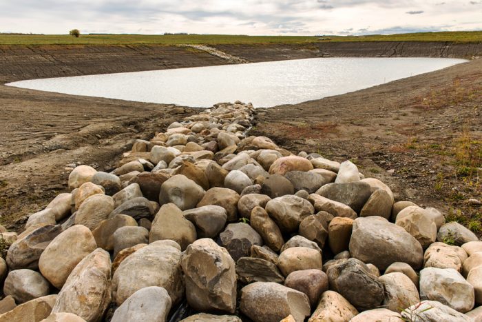
A giant frack-water storage pit at the site where three earthquakes were triggered in November, 2018. Photo: © Garth Lenz.
The initial 4.6 magnitude earthquake was felt by residents in their homes in Fort St. John and in Chetwynd, more than 80 kilometres away. Esther Pedersen, who raises horses on an acreage overlooking the Site C dam construction project, recalls being at home in her kitchen when the earthquake struck. She called it “a counter grabber.” A “strong jolt” was also felt at Site C, prompting BC Hydro to order an immediate evacuation of hundreds of construction workers. Two other earthquakes followed, one a magnitude 4, the other a magnitude 3.4.
In the immediate aftermath of the event, the Commission ordered CNRL to cease all fracking operations at the site.
Breaking the camel’s back
But was it CNRL and CNRL alone that was behind all the drama?
To better understand the insidious way that multiple fracking operations can lead to seismic events, Chapman looked closely at 56 earthquakes in the Montney that had magnitudes of 3 or more. Thousands of smaller earthquakes are associated with fracking activities, but Chapman chose to narrow his primary focus to only those earthquakes large enough in magnitude to be felt by people.
Using data from Natural Resources Canada, he pinpointed each earthquake epicentre on a map, and then drew a five-kilometre radius around each one. Then he used water data from the Commission to look at all the water pumped over time in fracking operations within the wider zones. (Fittingly, one of Chapman’s first actions upon joining the Commission in 2010 was to require that all fossil fuel companies operating in the province file quarterly reports on how much water they used to frack.)
Analyzing site-specific information on cumulative fracking activities, Chapman reached a far different conclusion about what led to the dramatic events in late November of that year.
In the days immediately leading up the cluster of strong earthquakes, Chapman found, CNRL pumped the equivalent of nearly six Olympic swimming pools of water into two wellbores 20 kilometres to the north of Site C.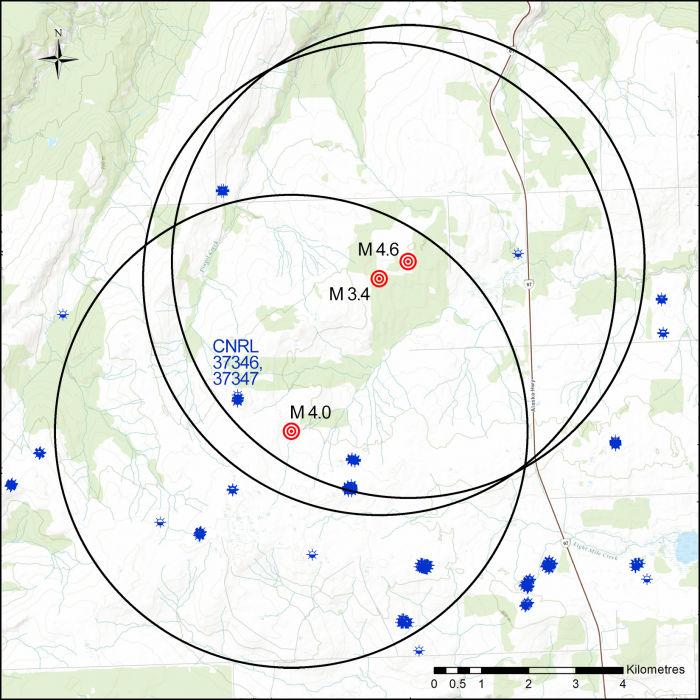
The three earthquakes in November 2018 occurred in a hot zone for fracking. The circles around the earthquake epicentres show everything within five kilometres. The blue blotches inside the circles identify where 109 wells were fracked. Map Credit: David Leversee.
But that water use paled in comparison to the 688 Olympic swimming pools worth of water that four companies including Ovintiv (formerly Encana), ARC Resources, Crew Energy and CNRL had already blasted underground at 109 other gas wells within five kilometres of the earthquake epicentres in the previous three years. When CNRL then added those last six Olympic swimming pools worth of water to the mix, it was like “the proverbial straw that broke the camel’s back,” Chapman concludes. In a subsequent interview he said that the case that cumulative effects are behind the earthquakes becomes even more compelling when you expand the radius by just two more kilometres. Then, the total amount of water used in the fracking operations nearby CNRL’s wells rises to an astonishing 2.93 million cubic metres and the number of fracked wells climbs to nearly 200.
Chapman also looked closely at the events surrounding a 4.6 magnitude earthquake, then the largest ever recorded in BC, which was set off three years earlier at a Petronas fracking operation near Pink Mountain north of Fort St. John. In the week before the strong earthquake on August 17, 2015, Petronas had pumped 67,625 cubic metres of water into three gas wells, Chapman reports. But in the two years prior, the same company had injected more than four times as much water into another 13 wells within five kilometres of the eventual earthquake’s epicenter.
Worse over time
“Things get worse over time,” Chapman said in an interview, noting that the earliest fracking operations do not appear to trigger many earthquakes but as time marches on they do. “It appears that once certain volumes of water are pumped underground that the geology is seeded such that earthquakes result more readily from fracking.”
Gail Atkinson, a renowned expert on the dangers posed to critical infrastructure such as major hydroelectric dams by induced earthquakes, is an earth sciences professor at the University of Western Ontario. Her work has highlighted how earthquakes induced by fracking can have more serious consequences for critical infrastructure than naturally occurring earthquakes because of the relatively shallower depths at which induced events occur. The nearer to the surface the earthquakes are, the closer that puts the ensuing shaking to dams and other vulnerable infrastructure.
Her work has been instrumental in convincing TransAlta, a company that owns and operates dams and other power facilities, to push for a fracking exclusion zone near its Brazeau dam in Alberta, an effort now being fought by fracking companies operating in the region.
“If you have an exclusion zone you’ll keep the cumulative effect out of a certain area,” Atkinson said in an interview. “What Allan Chapman’s article points to—and what we’ve also seen in observations in the articles we’ve been working on—is that once you start something going it’s easy to retrigger things. You’ll be fracking in an area, nothing much is happening, and then things start to pop off. And then it seems that everything you do is making things pop off. And that agrees with Allan’s basic idea that it is a cumulative effect.”
To reduce the risk of “priming the pump” and triggering earthquakes near vulnerable infrastructure, Atkinson says, you need to establish firm no-go zones where fracking is banned.
But that’s a big challenge now because both the BC and Alberta governments have effectively sold off rights to drill into the subsurface just about everywhere that oil or gas can conceivably be found.
As detailed in documents obtained through Freedom of Information requests by the Canadian Centre for Policy Alternatives, dam safety officials and engineers with BC Hydro have specifically sought such bans near their W.A.C. Bennett, Peace Canyon and Site C dams, out of concerns that nearby fracking operations could trigger earthquakes that damaged the dams. Or, in the worst case, led to a dam failure, an outcome that would have catastrophic impacts for thousands of people living downstream.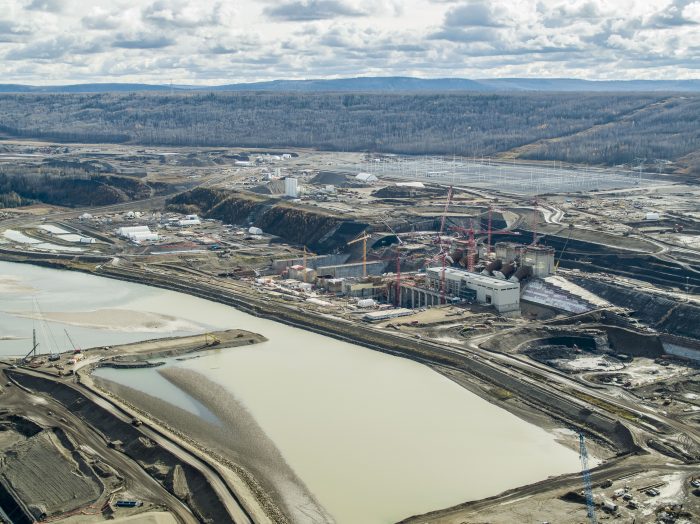
The Site C dam, now under construction, is just some of the critical infrastructure in northeast BC that could be at risk from fracking-induced earthquakes. Photo credit: Jayce Hawkins.
But the hydro utility’s efforts have yet to convince the Commission or provincial government to establish firm no-go zones, perhaps because of the compensation costs that the government would have to pay out to the companies it sold the subsurface rights to.
A lack of foresight
“This whole thing could have been avoided if there’d been a little bit more foresight on the behalf of those who were selling the rights to these subsurface properties and they simply had avoided making those sales,” Atkinson says. “BC did it. Alberta did it. They…sold leases without regards to the locations of critical infrastructure. And [now the companies have] put money into both buying those leases and into research and development to figuring out whether there’s oil and gas there. And now that they’ve invested all of that money, they want to reap the profits.”
Chapman concludes that a total of 439 earthquakes recorded by Natural Resources Canada in the Montney region between 2013 and 2019, had a “close association” with fracking and that the overwhelming majority of them—77 per cent—were linked to the fracking operations of just three companies led by Petronas with 209 associated earthquakes, Tourmaline Oil with 79 and Ovintiv (formerly Encana) with 38.
Petronas, which is a significant partner in the proposed Canada LNG facility, has such a high number of earthquakes associated with its operations partly because it operates in the northern portion of the Montney, which is geologically distinct from the more southern portion of the basin and treated as such by the Commission. Petronas is also the largest subsurface rights holder in the province and holds a monopoly position in the North Montney, Chapman found.
Chapman also found that 15 per cent of fracked gas wells in the Montney are associated with earthquakes, and that nearly 2 per cent of all fracked wells are associated with earthquakes that are magnitude 3 or stronger.
That is of concern because while the pump may already be primed for earthquakes of potentially great magnitude in northeast BC, the fracking companies are only just getting started in the Montney.
Chapman notes that between 2012 and 2019 a total of 39 million cubic metres of water—enough to fill 15,600 Olympic swimming pools—was blasted into the earth in the Montney. During that same timeframe, there was also a steady increase in the amount of water used per fracked well. From an average of just over 7,000 cubic metres of water per well in 2012, to more than 22,000 cubic metres by 2019.
When individual companies are looked at, the picture is even more complex. ConocoPhillips, for example, used 83,000 cubic metres of water at each of 13 wells it fracked in 2019. “It is not known whether ConocoPhillips is an outlier or a harbinger,” Chapman wrote. However, he notes that four other fracking companies each used 30,000 cubic metres of water or more per well in 2019, a trend that may not bode well for future frequency and severity of earthquakes.
Runaway earthquakes and traffic lights
To understand what lies ahead, Chapman says it is worth considering the very large well pads that the industry has built in the Montney. Carved out of what were once tracts of boreal forest or plunked down in farmer’s fields in the provincial Agricultural Land Reserve, those pads are generally designed to accommodate 20 or more fracked wells. At one monster pad built recently by Ovintiv, on farmland not far from the community of Taylor, up to 56 wells could eventually be drilled and fracked.
Right now, on average, most of the 639 “multi-well” pads in the Montney have just over 4 wells per pad on average.
Should the Coastal Gas Link pipeline and Canada LNG plant be built, there will be an explosion in fracking activity in northeast BC as the province becomes a liquefied natural gas exporter.
To give an idea of what lies ahead, Chapman estimated that it would take the “equivalent water volume of as many as 100,000 Olympic-size swimming pools” to fill out those 639 multi-well pads with an average of 20 wells each. That almost certainly would result in not only more earthquakes, but stronger earthquakes.
According to a recent scientific panel that reported to the provincial government, there is no scientifically credible way to predict how large future induced earthquakes may one day be. Their strength will only be constrained by the unique geological conditions in which they occur.
At present, the only tool that the Oil and Gas Commission employs to reduce earthquake risk is a “traffic light protocol,” that calls for the suspension of fracking if a magnitude 4 or greater earthquake is triggered in the Montney. The protocol is somewhat more stringent in the southern portion of the Montney, in an area the Commission calls the Kiskatinaw Seismic Monitoring and Mitigation Area or KSMMA. There, the threshold is set at magnitude 3. Named after the nearby Kiskatinaw river, the KSMMA is a hot zone for fracking.
In the traffic light protocol, suspension equals a red light.
The traffic light protocol also calls for mandatory reporting of smaller earthquakes if they reach certain lower magnitudes and for various “mitigation efforts” to be undertaken when those earthquakes occur to theoretically prevent bigger earthquakes.
This is like approaching a yellow light and proceeding with caution.
Unfortunately, Chapman says, the protocol system has not prevented higher magnitude earthquakes from being triggered by fracking. Roughly a third of the larger “induced” earthquakes in the Montney were not preceded by any smaller earthquakes. He adds that if such systems are to work they may have to dramatically lower the magnitudes at which fracking-induced earthquakes trigger red or yellow lights.
Just such a proposal has been made recently by four scientists at Stanford University, led by geophysicist Ryan Shultz. In the paper, the scientists say tougher traffic light systems may be necessary to prevent “runaway earthquakes” and the considerable damage they could cause.
The Commission, which received a copy of Chapman’s report the day before its publication, was asked to comment on Chapman’s conclusion that the traffic light protocol had not prevented earthquakes from occurring, an issue it chose not to answer directly.
Instead, it stood by its decision to implement the traffic light system that it had put in place in the Kiskatinaw area in particular, and added that it had also worked with unidentified partners to increase the number of public seismic monitoring stations in northeast BC from 11 to 22.
“The Commission has taken a leadership role in the detection and mitigation of induced seismicity associated with oil and gas development – in North America and globally. Our geologists and seismic experts use sound, peer-reviewed research, data and predictive modelling to understand, regulate and mitigate seismic activity,” the Commission said, in part, referring to ongoing work it is doing on induced earthquakes with researchers at McGill and the University of Calgary.
A cautionary tale—deadly earthquakes in China
But ongoing research aside, Chapman warns that earthquakes like the 5.7 and 5.3 magnitude events that occurred in China’s Sichuan province in 2018 and 2019 could occur in northeast BC. Those two events in China killed two people, injured many more, destroyed or badly damaged 400 houses, caused millions of dollars in damages and triggered landslides.
His list of communities and critical infrastructure that require “enhanced” protections, which could include “no-fracking zones” or much tighter controls on fracking in proximity to at-risk communities and assets, is long and includes:
- The communities of Dawson Creek, Fort St. John, Taylor, Hudson’s Hope and the Halfway River First Nation community of Upper Halfway among others.
- BC Hydro’s two existing dams on the Peace River—the W.A.C. Bennett and Peace Canyon dams—as well as the Site C dam under construction and years away from completion.
- Community water supplies and treatment plants.
- The Taylor gas plant and the Taylor suspension bridge.
- Dozens of earthen dams built without permits by oil and gas companies to capture water used in their fracking operations.
At the end of his paper, Chapman concludes that “British Columbia’s experiment” with fracking gas well after gas well has resulted in the province having “the sobering distinction of having produced some of the world’s largest fracking-induced earthquakes.”
The provincial government, in his view, owes a duty to the public to ensure that future earthquakes triggered by fracking do not kill and maim people and badly damage or destroy vital infrastructure.
“Part of what motivated me to write this paper was to put the focus on the risk to the people in these communities and the infrastructure that’s in these high-risk areas,” Chapman said in an interview. “I very strongly believe that the primary function of government should be to protect the people that it’s governing.”
Fracking likely to create stronger, more common earthquakes in northern B.C.: study by Bob Webber, Canadian Press, May 26, 2017, The Globe and Mail
More damaging earthquakes can be expected more often in northern British Columbia as fracking oil and gas wells increases pressure underground, says newly published research.
“It makes earthquakes more common and it makes larger ones more common,” said Allan Chapman, an independent researcher and formerly senior scientist with the B.C. Oil and Gas Commission.
“There appears to be a fairly strong relationship between this cumulative water loading underground and the magnitude of an event.”
Chapman said his study suggests that homes and infrastructure in northern B.C. could be at risk from earthquakes and that current government safeguards are inadequate. ![]() Homes already are. Of course safeguards are inadequate, they’re grossly inadequate in Alberta and SK too, industry won’t allow it any other way. We need to be expendable (public infrastructure too) so as to feed their greed.
Homes already are. Of course safeguards are inadequate, they’re grossly inadequate in Alberta and SK too, industry won’t allow it any other way. We need to be expendable (public infrastructure too) so as to feed their greed.![]()
“For many of these large events there may be no warning.”
Chapman looked at the Montney field near Fort St. John, B.C. For years, that area has seen intensive oil and gas development using fracking, which injects high-pressure fluids deep underground to fracture rocks and release oil and gas.
That technique has become increasingly associated with earthquakes. In parts of the Montney, a total of 439 earthquakes up to 4.6 magnitude were associated with fracking between 2013 and 2019.
Previous research has linked the pressure at which the fluids are injected to the resulting temblor.
Chapman looked at the total volumes of water injected wells within five kilometres of an earthquake epicentre. He found that areas where water volumes built up over time – sometimes from several different companies – were associated with stronger magnitudes of at least 3.0, enough to be felt on the surface.
The number of earthquakes also increased.
One part of the Montney generated about 20 earthquakes when one million cubic metres of fluids were pumped underground. That same area registered more than 160 events when injection grew to 3.5 million cubic metres.
“It makes the earthquakes more common and it makes the large ones more common,” Chapman said.
He noted that fracking is expected to increase in the Montney. Many sites only have four wells on a pad.
“At full development, you’re expecting to see 20 or 30 wells on a pad. What’s going to happen if the amount of fracking rises substantially?”
In a statement from spokeswoman Lannea Parfitt, The B.C. Oil and Gas Commission criticized Chapman’s peer-reviewed work.
“Our geological and engineering experts have concluded it is based on a number of unproven assumptions or incomplete consideration of the factors cited,” the commission said in an e-mail.
The commission said the paper didn’t account for variation in rock strata, fault types and local stresses. It called Chapman’s conclusions “speculation.”
“Our geologists and seismic experts use sound, peer-reviewed research, data, and predictive modelling to understand, regulate and mitigate seismic activity,” it said.
B.C. and Alberta have instituted what’s called a “traffic light” approach to manage risk. Companies are expected to reduce pumping pressure and volume once light earthquakes are felt and to stop completely as they increase.
But Chapman points out four of the region’s five biggest recent earthquakes – all over magnitude 4.0 – weren’t preceded by any warnings.
“There was no precursor,” he said.
“Magnitude 4 is a big event, shaking the ground for 30 kilometres. If you had one within a couple kilometres of your house, you’d be worried about damage.”
Fracking has already induced earthquakes in China rated at 5.3, Chapman’s study says.
“There is no upper limit.”
Fort St. John, with 20,000 residents, felt five earthquakes between 2013 and 2019. The largest was rated at 4.2.
The region’s bridges and dams could also be vulnerable, Chapman said.
He is joining other researchers who have already called for a no-fracking zone in areas with susceptible geology, homes and buildings.
“We do need to look at places that are too high-value. They need to have a no-frack zone around them.”
Hydraulic Fracturing, Cumulative Development and Earthquakes in the Peace River Region of British Columbia, Canada by Allan R. Chapman, Chapman Geoscience Ltd., May, 2021, Journal of Geoscience and Environment Protection, Vol.9 No.5
Abstract
Unconventional petroleum development involving large volume fluid injection into horizontal ![]() and slant, vertical, deviated (I felt tremors on my property while Encana was perforating a deviated well three quarters of a mile away, and watched cracks develop in the foundation of my home)
and slant, vertical, deviated (I felt tremors on my property while Encana was perforating a deviated well three quarters of a mile away, and watched cracks develop in the foundation of my home)![]() well bores, referred to as hydraulic fracturing (HF, or fracking), began in the Montney Trend of northeast British Columbia, Canada, in 2005, quickly initiating earthquakes. Earthquake frequency increased substantially in the Montney by 2008, in relation to the number of wells fracked and the volume of injected frack water. A spatiotemporal filter was used to associate earthquakes with HF wells. A total of 439 earthquakes (M 1.0-4.6 (NRCAN catalogue) during 2013-2019 have close association with HF activity, of which 77% are associated with three operators. Fifteen percent of HF wells in the Montney are associated with these earthquakes, while 1.7% of HF wells are associated with M≥3.0 earthquakes. There are strong linear relationships between the maximum earthquake magnitude each year and the annual volume of injected frack fluid. M≥3.0 earthquakes are associated with large cumulative frack water volumes for antecedent time periods of 1-3 years, often with fluid injection by multiple operators. Eighty-seven percent of the Montney M≥3.0 earthquakes have associated HF triggering events, but a few are sufficiently distant to be ambiguous. Distances from the induced earthquake epicentres indicate a variety of causal mechanisms are involved. It is concluded that ~60-70% of M≥3.0 earthquakes are induced by hydraulic fracturing. HF-induced earthquakes can be considered in part related to the cumulative development density from multiple proximal operators and cumulative antecedent fluid injection over periods ranging from a few months to a few years.
well bores, referred to as hydraulic fracturing (HF, or fracking), began in the Montney Trend of northeast British Columbia, Canada, in 2005, quickly initiating earthquakes. Earthquake frequency increased substantially in the Montney by 2008, in relation to the number of wells fracked and the volume of injected frack water. A spatiotemporal filter was used to associate earthquakes with HF wells. A total of 439 earthquakes (M 1.0-4.6 (NRCAN catalogue) during 2013-2019 have close association with HF activity, of which 77% are associated with three operators. Fifteen percent of HF wells in the Montney are associated with these earthquakes, while 1.7% of HF wells are associated with M≥3.0 earthquakes. There are strong linear relationships between the maximum earthquake magnitude each year and the annual volume of injected frack fluid. M≥3.0 earthquakes are associated with large cumulative frack water volumes for antecedent time periods of 1-3 years, often with fluid injection by multiple operators. Eighty-seven percent of the Montney M≥3.0 earthquakes have associated HF triggering events, but a few are sufficiently distant to be ambiguous. Distances from the induced earthquake epicentres indicate a variety of causal mechanisms are involved. It is concluded that ~60-70% of M≥3.0 earthquakes are induced by hydraulic fracturing. HF-induced earthquakes can be considered in part related to the cumulative development density from multiple proximal operators and cumulative antecedent fluid injection over periods ranging from a few months to a few years.
It is probable that induced earthquakes of M>5 will occur in the future.
There are significant public safety, infrastructure risks associated with future HF-induced earthquakes in the Peace River area. To carry out HF operations effectively and safely, potentially destructive earthquakes must be avoided or mitigated. The Traffic Light Protocol mitigation system used in British Columbia appears unlikely to prevent large magnitude earthquakes. ![]() Of course it won’t! Same as it isn’t in Alberta and didn’t in the UK. The extensive damages caused by frac quakes in UK led the gov’t to ban it. The traffic light system is nothing but a ruse to quiet harmed families and the public, so as to let (largely foreign-owned) oil and gas companies keep frac’ing, no matter how many are killed, or how much damage is caused – taxpayers will pay for it all and the harmed with their homes, farms, and lives.
Of course it won’t! Same as it isn’t in Alberta and didn’t in the UK. The extensive damages caused by frac quakes in UK led the gov’t to ban it. The traffic light system is nothing but a ruse to quiet harmed families and the public, so as to let (largely foreign-owned) oil and gas companies keep frac’ing, no matter how many are killed, or how much damage is caused – taxpayers will pay for it all and the harmed with their homes, farms, and lives.![]() Risk avoidance therefore becomes important and could include the establishment of frack-free zones proximal to populations and critical infrastructure.
Risk avoidance therefore becomes important and could include the establishment of frack-free zones proximal to populations and critical infrastructure.
- Introduction
Earthquakes associated with petroleum production in northeastern British Columbia
(NEBC), referred to as induced seismicity, have been recognized for many decades, beginning with large-volume fluid injections into oil reservoirs to enhance conventional oil
recovery (Horner et al., 1994), and fluid injection into oil and gas wastewater disposal
wells (Schultz et al., 2014; Weingarten et al., 2015, BCOGC, 2014). More recently,
earthquake activity initiated by hydraulic fracturing has emerged as a significant concern
in the Peace River region of NEBC, triggering focused research (Atkinson et al., 2020;
Schultz et al., 2018; Barbaie Mahani et al., 2017; Atkinson et al., 2016; Bao and Eaton,
2016; others). Hydraulic fracturing (also referred to as HF, or the colloquial “fracking” in
this paper) is a well stimulation technique that is a key element of unconventional petroleum development (also referred to as shale gas, tight gas, shale oil, etc.), where high
volume water-based fluid injection along horizontal well bores is used to fracture the petroleum-bearing rock, creating permeability and enhancing petroleum recovery.
This paper examines relationships between hydraulic fracturing and earthquakes in the
Peace River region of NEBC. Numerous “felt” earthquakes have occurred in Peace region over the past 10+ years, notably including three large events in a 48-minute period
on 30 November 2018, with moment magnitudes (Mw) of 4.6, 4.0 and 3.4, triggering
temporary work shutdown at the BC Hydro Site C dam construction site located 23 km to
the north (Nikiforuk, 2018), and, as well, a Mw 4.6 earthquake on 17 August 2015 at a
remote location 20 km east of the community of Pink Mountain. The significance of the
public safety and infrastructure risks associated with HF-related earthquakes in the Peace
River region cannot be overstated. This paper examines the frequency and magnitude of
induced earthquakes in relation to HF injection fluid volumes over varying antecedent
time periods; it quantifies differences amongst petroleum operators in relation to induced
earthquakes; and it evaluates the mitigation approaches, including regulatory requirements, intended to reduce potential public safety, infrastructure and environmental risks.
It suggests what the earthquake future for the Peace Region might be. Investigation of
induced earthquakes associated with the operation of water disposal wells is not included.
Study Area
This study focuses on the Montney Play Trend (referred to in this paper as the Montney).
Following developments in the Barnett Shale in Texas in the late 1990s, the industry
transformation in BC to unconventional petroleum began with the 2003-2010 gold rush
of petroleum tenure sales of $7.5 billion for 4.7 million hectares of land across NEBC
(BCGOV, 2020a). The first multistage HF in a NEBC horizontal well occurred near
Dawson Creek in July 2005 (BCOGC 2012a). In the years’ since, many thousands of
wells have been drilled and fracked in four areas – the Horn River Basin, Liard basin,
Cordova Embayment, and the Montney Trend. The BC Oil and Gas Commission
(BCOGC), the regulator of oil and gas activity in BC, reports that unconventional petroleum activity in the Horn River Basin, the Liard basin and Cordova Embayment was
largely abandoned by 2016 (BCOGC, 2021), leaving just the Montney Trend with activity.
The Montney has an area of ~26,600 km2, extending from south of the community of
Dawson Creek to ~200 km north-west of the community of Fort St John, and consisting
of Triassic aged siltstones (Euzen et al., 2018; BCOGC 2012a). Most of the Montney is
contained within the drainage of the Peace River, although the northern portions are
within the Sikanni Chief River watershed, which drains northward to the Fort Nelson and Liard rivers.
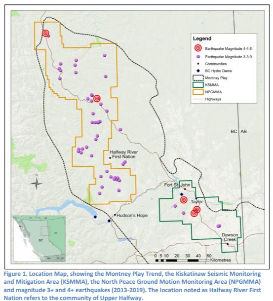
The Montney has been divided by the BCOGC into two primary zones for the understanding of HF-induced earthquakes (Figure 1). These are the Kiskatinaw Seismic Monitoring and Mitigation Area (KSMMA) and the North Peace Ground Motion Monitoring Area (NPGMMA). The KSMMA comprises 9% of the Montney and is centred on the Peace River, encompassing the communities of Dawson Creek, Fort St. John and Taylor. The BC Hydro Site C dam location is within the KSMMA. The NPGMMA comprises 26% of the Montney, extending from the north side of the Peace River near Hudson’s Hope, skirting the west edge of the community of Upper Halfway (Halfway River First Nation), to north of Pink Mountain. The BC Hydro WAC Bennett and Peace Canyon dams are proximal to the south end of the NPGMMA. The remaining 65% of the Montney is seismically unzoned. The KSMMA is predominantly private agricultural land with dispersed rural population and three sizable communities, whereas the NPGMMA is predominantly sparsely populated Crown land with a significant First Nation community.
Structural differences between the KSMMA and NPGMMA may account for seismogenic differences between the two areas. The KSMMA overlies the Dawson Creek Graben Complex, where faults have been reactivated due to ice compression and decompression during recent continental glaciation (Barclay et al., 1990), whereas the dominant seismogenicity of the NPGMMA results from movement along strike-slip faults associated with the Hay River Fault Zone, in the thrust-and-fold belt of the Rocky Mountain foothills (Thompson, 1989).
- Data and Analysis
The primary data used for this report are earthquake data compiled and published in the Canadian National Earthquake Database by Natural Resources Canada (NRCAN), and well completion data compiled and published by the BCOGC. The National Earthquake Database is based on the Canadian National Seismographic Network (CNSN) and is the de facto standard for earthquake monitoring and mapping in Canada (Visser et al., 2017). The network currently consists of 12 stations in NEBC, of which only two were operating before March 2013. Earthquake data for 2000-2019 were extracted from the National Earthquake Database (NRCAN 2020). Because of the enhancement of the CNSN network in early 2013, the pre- and post-2013 seismic events are not directly comparable. Analysis of data for the 2000-2012 period was limited to only the “felt” events of M≥3.0. Earthquakes from the NEBC earthquake catalogues compiled by Visser et al. (2017, 2020) were extracted and used for portions of this report. These catalogues combine private industry and university seismographic data with the NRCAN data and report a significantly greater number of small magnitude earthquakes than the NRCAN catalogue. As well, they have enhanced earthquake epicentre locational accuracy. However, because the Visser (2017, 2020) catalogues are limited to just 2014-2016 for all the Montney and to just the KSMMA portion of the Montney for 2017-2018, the primary analysis for this report is based on the NRCAN earthquake catalogue.
The well and HF data were compiled from the BCOGC’s Frac Focus data set, for the 2012 to 2019 period (BCOGC 2020a), a year prior to the period of enhanced NRCAN seismic data. The Frac Focus data were summarized to create one record per well, for all the petroleum wells fracked during the period. Other data extracted from the BCOGC’s Open Data Portal (BCOGC 2020b, 2020c) and from Geoscience BC (2020) were used in this analysis.
Wells and well pads were associated with earthquakes using a spatiotemporal association filter, using the QGIS geographic information system (QGIS, 2020). A 5-km radius buffer was assigned to each earthquake, consistent with the approach used by BCOGC (2012b) and others. The buffer radius is slightly larger than the ~3 km length of horizontal bore associated with the unconventional petroleum wells (Lemko and Foster 2016). In addition, the buffer accommodates some of the accuracy uncertainty in earthquake location from the CNSN.
For each earthquake where there are wells located within the 5-km radius buffer, associated HF water volumes for varying antecedent time periods were calculated: 30 days, 90 days, 1 year, 2 years, 3 years, and total antecedent. For this report, the antecedent period of 90 days is used to define an HF-associated earthquake, similar to Ghofrani and Atkinson (2020). This does not imply direct cause and effect between an individual well or well operator and the earthquake but is noted as an association. In addition, the frack water volume for the most probable HF event triggering an M≥3.0 earthquake as determined for the well fracked immediately (up to 14 days) before the earthquake. Initially, the query for the triggering HF events was contained within the 5-km radius buffer. Upon review it was evident that many of the triggering HF events were more distant that 5-km from the earthquake. There were clusters of earthquakes associated with fracking on a well pad, where some of the earthquakes in the cluster were well beyond 5-km from the triggering well. As well, comparison of the earthquake epicentres from the Visser (2017, 2020) and NRCAN catalogues, for earthquakes contained in both catalogues, indicted spatial uncertainty in epicentre location of up to 10-km. As a result, a second query was done using a 15-km buffer radius. Additionally, precursor earthquakes were determined for all the M≥3.0 earthquakes, determined as any earthquake of M≥2.0 occurring within a 10-km radius and up to 30-days before the M≥3.0 event, using the NRCAN catalogue
Statistical analysis was completed using Systat v.13 (Systat, 2020).
Analysis and Results
Wells, Well Pads, Water Use
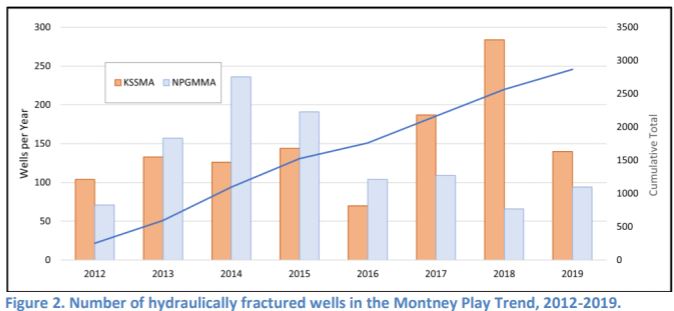
A total of 2,865 wells in the Montney are reported as being hydraulically fractured during the 2012-2019 period (Figure 2).
[Many more excellent visuals and tables in Chapman’s paper.]
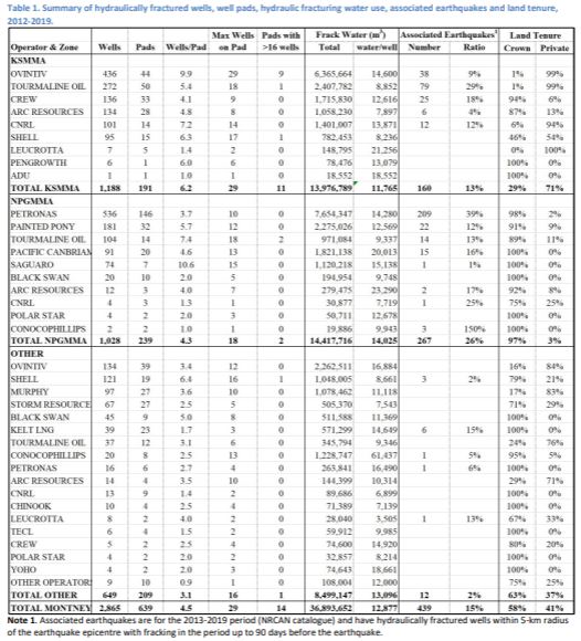
The five largest operators are Ovintiv (formerly Encana) – 570 wells, Petronas (formerly Progress Energy) – 552 wells, Tourmaline Oil – 413 wells, Shell – 255 wells and Painted Pony – 181 wells, together comprising almost 70% of the HF wells over the eight years. There are differences across the zones in the Montney. Despite being only 9% of the Montney area, 42% of the Montney HF wells are in the KSSMA, with Ovintiv having the greatest number of wells, followed by Tourmaline Oil, Shell, Crew Energy, ARC Resources and Canadian Natural Resources Ltd. (CNRL). These six operators are responsible for 99% of the HF wells in the KSSMA. Different companies dominate in the NPGMMA, containing 36% of the Montney HF wells. Petronas alone accounts for 52% of the NPGMMA HF wells and is followed somewhat distantly by Painted Pony, Tourmaline Oil, Pacific Canbriam and Saguaro. Outside these two seismically zoned areas a variety of companies operate in the remaining 65% of the Montney, led by Ovintiv, Shell, Murphy Oil, Storm Resources and ConocoPhillips. The peak in HF, to date, in the NPGMMA was 2014-2015, while the peak in the KSMMA was later, in 2018.
Trends over time in HF activity across the Montney are related to economic factors, with industry attention moving away from methane or natural gas and towards natural gas liquids (condensate). The NPGGA contains largely dry gas (i.e., just methane) whereas the KSMMA has abundant natural gas liquids (BCOGC 2012a). During 2016-2019 natural gas liquids averaged $6.38 (USD per MMBtu) (Canada Energy Regulator, 2020) a substantial premium to the dry methane price of $2.40 (USD per MMBtu), enhancing the development focus on the KSMMA area and away from the NPGMMA.
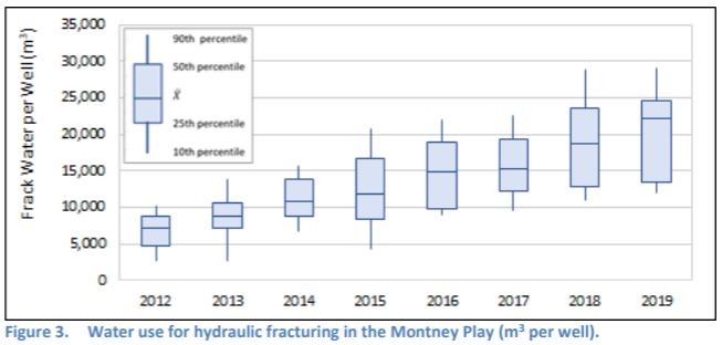
Over the 2012-2019 period, a total of 39 million m3 of water was used for fracking in the Montney. The volume of water used per well has increased steadily over the eight-year period, from an average of 7,077 m3 per well in 2012 to 22,054 m3 per well in 2019 (Figure 3). ConocoPhillips stands out, using an average of 83,000 m3 per well for 13 wells in 2019. It is not known whether ConocoPhillips is an outlier or a harbinger, however, there appears to be a trend emerging amongst several Montney operators towards significantly larger water use per well. Ovintiv, Petronas, CNRL, ARC Resources, Pacific Canbriam and ConocoPhillips all had multiple HF wells in 2019 using 30,000+ m3 per well.
The 2,865 wells hydraulically fractured during 2012-2019 are situated on a total of 639 well pads, with a Montney average of 4.5 wells per pad, well below the 20+ wells on each well pad anticipated at full development, as has been done on some pads in the KSMMA (Table 1). The small number of wells per pad suggests that most of the Montney operations to date have remained in the exploratory and appraisal phases of activity, with some exceptions. Only in the KSMMA are some operators approaching full development on some well pads. Ovintiv has one well pad with 29 HF wells and has six pads with 20+ wells. In the NPGMMA, Petronas, the largest operator, has built-out extensive infrastructure across a large geographic area to appraise production potential, but has minimal activity to date at the individual well pads. Petronas has 146 well pads in the NPGMMA, averaging 3.7 HF wells per pad, with no more than 10 wells on any pad.
In cases of multiple wells on a single well pad, the water injection can be very large. ConocoPhillips injected nearly 1.1 million m3 of frack fluid from a single well pad, followed by Ovintiv with 550,000 m3 injected from one pad and five pads each with greater than 300,000 m3 total frack fluid injection.
Earthquakes
The Canadian National Earthquake Database contains 175 earthquakes for the 2000-2012 period (M 1.0 – 4.2) with epicentres in the Montney, of which 37 earthquakes were M≥3.0, with a maximum magnitude of M 4.2. For just the 2013-2019 period, following the enhancement of the seismic monitoring network, 975 earthquakes were recorded (M 1.0-4.6) across the Montney, 647 in the NPGMMA, 227 in the KSSMA and 101 across the remainder of the Montney. Fifty-six earthquakes (6%) were M≥3.0. Five earthquakes exceeded M 4.0 (three in the KSMMA and two in the NPGMMA). Earthquakes with magnitudes ≥3.0 are generally “felt” with ground shaking on the ground surface for some distance from the earthquake epicentre; at magnitudes ≥4.0 the surface manifestation can be substantial, with damage to buildings and infrastructure (Atkinson et al., 2020; Lei et al., 2019). These M≥3.0 earthquakes are a threshold magnitude for events of particular interest, as they are the drivers of public safety and infrastructure risk. As noted, the earthquake catalogues of Visser et al. (2017, 2020) contain a substantially larger number of small earthquakes (generally less than M 2).
Earthquakes and Hydraulic Fracturing
Earthquake Frequency
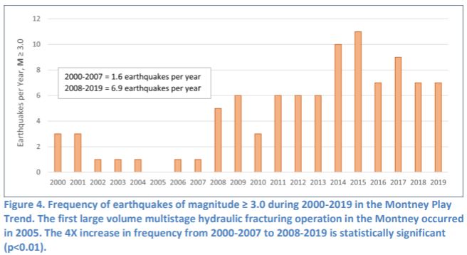
A significant increase in the frequency of earthquakes M≥3.0 magnitude appears to have occurred in 2008, shortly after the start of HF activity in the Montney in 2005 (Figure 4). For the Montney in its entirety, the frequency increased from 1.6 earthquakes (M≥3.0) per year during 2000-2007, to almost 6.9 per year during 2008-2019, a 4X increase. Most of this change, however, comes from the NPGMMA, going from 0.3 earthquakes (M≥3.0) per year during 2000-2007 to 5.5 per year during 2008-2019, an increase of almost 20X. For the KSSMA, the shift to increased earthquake frequency occurred later, in 2018, going from 0.3 M≥3.0 earthquakes per year in 2000-2017 to an average of 3.0 per year in 2018-2019, a 10X increase. These changes are all statistically significant (Student’s t-test, p<0.01), although the period of change for the KSMMA is short and should be considered with caution. For the Montney outside the NPGMMA and KSSMA, there is no change in the frequency of earthquakes over the 2000-2019 period.
The number of M≥3.0 earthquakes in both the NPGMMA and KSMMA each year are positively correlated with the number of HF wells and the volume of frack water injected each year (R2adj = 0.40 – 0.58, p<0.05) (Figure 5). Also, in the NPGMMA there is a strong positive correlation between the total number of earthquakes each year and the total volume of injected frack fluid (R2adj = 0.81, p<0.01). This relationship is not evident in the KSMMA. Increased seismicity rates did not begin in the KSMMA until 2018, delayed from the beginning of HF activity but coinciding with the substantial increase in HF activity in 2017 when accelerated fracking for natural gas liquids began (refer to Figure 2). Schultz et al. (2018) observed a similar delay in the initiation of HF-induced seismicity in the Duvernay Play in Alberta.
Of the 975 earthquakes recorded in the Montney during 2013-2019, 439 (50%) have a close spatiotemporal association with hydraulic fracturing (within a 5-km radius and within 90 days before the earthquake) (refer to Table 1). A total of 751 earthquakes (77%) have proximal frack fluid injection within 5-km of the epicentre during the previous three years. For the 439 earthquakes with the closest spatiotemporal association with hydraulic fracturing operations, 160 are in the KSMMA, led by Tourmaline Oil with 79 associated earthquakes, Ovintiv with 38, Crew Energy with 25, CNRL with 12 and ARC Resources with 6. Tourmaline Oil and Ovintiv together are associated with 73% of all the earthquakes in the KSMMA. There were 267 associated earthquakes in the NPGMMA, led by Petronas with 209. Painted Pony, Pacific Canbriam and Tourmaline Oil are far behind, with 22, 15 and 14 associated earthquakes, respectively. Petronas is notable – it alone is associated with 78% of the earthquakes in the NPGMMA and almost one-half the earthquakes in the entire Montney over the 2013-2019 period.
Of the 56 M≥3.0 earthquakes that occurred in the Montney over the 2013-2019 period, 30 (54%) have a clear spatiotemporal association with proximal hydraulic fracturing (Table 2), while 45 (80%) have proximal frack fluid injection at some time in the three years before the earthquake. The 5-km and 90-day spatiotemporal filter used in this report clearly does not encompass all earthquakes associated with hydraulic fracturing. An additional eight earthquakes have apparent triggering HF operations (discussed below) more distant than 5-km from the earthquake epicentre and are not captured by the 5-km filter. As well, the strong linear relationship between earthquake frequency and annual total frack fluid injection, along with the relationship between M≥3.0 earthquakes and their associated antecedent one- to three-year cumulative frack fluid injection (Table 3) as discussed below, supports the conclusion that HF association with earthquakes extends beyond the boundaries of a 5-km and 90-day filter. These lead to a conclusion that ~60-70% of observed M≥3.0 seismicity in the Montney is related to hydraulic fracturing activity, a result comparable to Atkinson et al. (2016) and Ghofrani and Atkinson (2021).
Differences in seismic susceptibility across the Montney are evident. Fifteen percent of hydraulically fractured wells in the Montney during 2012-2019 have close spatiotemporal association with earthquakes. The NPGMMA has the highest rate of induced seismicity, with 26% of HF wells associated with earthquakes, while the rate in the KSMMA is about one-half that, at 13%. The remainder of the Montney outside these two zones appears to have a low susceptibility to HF-induced earthquakes, with a rate of only 2%. Also, there are clear differences in associated earthquake rates among operators, possibly indicative of geologic and tectonic differences across the Montney and within the zones, and possibly also related to differences in hydraulic fracturing procedures (pump rate, volume per stage, etc.). Petronas leads with the highest earthquake rate – 39% of its HF wells are associated with earthquakes, followed by Tourmaline Oil in the KSMMA with an associated earthquake rate of 29%. Ovintiv, the largest operator in the KSMMA, has an associated earthquake rate that is one-third of Tourmaline’s, at 9% (refer to Table 1).
The rate of association of M≥3.0 earthquakes with HF wells is 1.7% for the Montney in total, ranging from 3.9% for the NPGMMA to 0.6% for the KSMMA, and with a rate of <0.2% for the remainder of the Montney. As noted above, these should be considered the low range of HF-earthquake association, since there are eight additional M≥3.0 earth-quakes with triggering HF wells beyond 5-km that were not captured by the 5-km and 90-day spatiotemporal filter used in this analysis. These are comparable to the association rates reported by Ghofani and Atkinson (2020, 2021) across the Western Canada Sedimentary Basin but are higher than those of Atkinson et al. (2016). Ghofrani and Atkinson (2020) consider the Montney as a single unit. It would be beneficial to future research to consider the substantial differences in seismogenicity within the Montney, likely related to differences in the geologic foundation that is producing earthquakes in response to large volume frack fluid injection.
Earthquake Magnitude
Both the NPGMMA and KSMMA exhibit linear relationships between the maximum earthquake magnitude each year and the annual volume of injected frack fluid (R2adj = 0.57 – 0.73, p<0.05) (refer to Figure 5). This is a key consideration, given that the unconventional petroleum development in the Montney to date has been limited, with the number of wells and the volumes of frack fluid injection per pad to date well below the levels anticipated at full development.
Cumulative antecedent HF injection volume appears to be an important factor for inducing M≥3.0 earthquakes. Table 3 presents the mean and median HF fluid volumes for the 30-day, 90-day, 1-year, 2-year, 3-year and total cumulative periods associated with earthquakes in the Montney, separated into categories of M≥3.0 and M≤2.9. The data show no statistical association between earthquake magnitude and frack fluid volume for just the 30-day and 90-day periods. However, beginning at the 1-year antecedent period the M≥3.0 earthquakes are associated with substantially larger cumulative frack water volumes compared to the M≤2.9 events (Figure 6). The differences for the 1-year, 2-year, 3-year and total antecedent periods for the KSMMA are all statistically significant (Mann-Whitney U test, p<0.05), while the differences in just the 1-year and total antecedent periods are significant for the NPGMMA. As well, M≥3.0 earthquakes are associated with a significantly greater number and density of proximal HF wells (87 wells within 5-km, 1.10 wells/km2) compared to M≤2.9 earthquakes (45 wells within 5-km, 0.57 wells/km2) (Table 4). The NPGMMA also exhibits a greater number of HF wells proximal to M≥3.0 earthquakes (17 wells within 5-km, 0.22 wells/km2) compared to M≤2.9 earthquakes (11 wells within 5-km, 0.14 wells/km2). These differences are statis-tically significant (Mann-Whitey U, p<0.05). Proximal HF well density and antecedent frack fluid injection volumes are co-related variables. Earthquakes induced by hydraulic fracturing cannot be considered just in relation to a single HF well but must be considered as an outcome related to the cumulative development density from multiple proximal operators and cumulative fluid injection over periods ranging from a few months to a few years.
In most cases of HF-associated earthquakes in the Montney, a single operator was responsible for all the HF activity within 90 days of the earthquake (97%). However, for 1-year and longer antecedent periods multiple operators in proximity are commonly linked to induced earthquakes. As many as 29% percent of the Montney earthquakes are associated with hydraulic fracturing conducted by multiple operators over antecedent time periods of one year and longer, in some cases as many as four operators. The KSMMA, where there is a greater density of HF development to date, exhibits the highest rate of multiple operator association with earthquakes, at 59%. The NPGMMA, which has a lower density of development, has as many as 19% of earthquakes with multiple operator association. The smaller percentage of co-association in the NPGMMA is mostly due to the dominance of Petronas and the lack of adjacency between them and other operators.
The three earthquakes that occurred on 30 November 2018 (MW 4.6, 4.0 and 3.4) provide a good example of multiple operator association. They were closely associated with nearby well completion operations conducted by CNRL, where 14,489 m3 of frack water was injected by CNRL into two horizontal wells (CNRL HZ Septimus G05-22-081-18 and H05-22-081-18) on a nearby well pad in the preceding 7-day period. However, before that, a total 1.72 million m3 of frack water was injected within 5-km radius of the three earthquake epicentres in a total of 109 HF wells associated with four operators, led by Ovintiv (76 wells, 1.26 million m3), followed by CNRL (25 wells, 425,318 m3), Arc Resources (8 wells, 41,009 m3) and Crew Energy (1 well, 7,653 m3). Injected frack water can migrate some distance through preferential pathways such as the natural geologic fault and fracture structure, increasing pore pressures well beyond the proximity of the horizontal well bore (Atkinson et al. 2016; Schultz et. al, 2015; Atkinson et al. 2020). This geologic co-mingling of HF water from multiple operators or from a single operator across a large geographic space and over varying antecedent time periods makes difficult the task of ascertaining earthquake cause and effect and makes difficult the determination of linkage to a specific HF operation. Also, it indicates that fracking-induced earthquakes are a cumulative development effect with responsibility commonly shared amongst several operators injecting large volumes of frack fluids, or a single operator injecting frack fluids at multiple wells and/or well pads, within geographic bounds.
Triggering Events and Precursor Events
The Montney data indicate that most of the M≥3.0 earthquakes are triggered by fracking of a single well, or a small group of wells on a single well pad, in the days before the earthquake. Eighty-seven percent for the Montney M≥3.0 earthquakes have associated HF events that appear likely to be the triggering events, with fracking occurring up to 14 days before the earthquake (…), with distances ranging from 0.9 km to 15.0 km (…). These are associations rather than deterministic cause and effect, and uncertainty increases for the earthquakes with the most distant triggers. If the events with trigger distances of >10km were discounted, the association rate drops to ~70%, similar to the rate determined from the spatiotemporal filter analysis concluded above. The mean triggering frack fluid volume is 15,100 m3 (refer to Table 2), representing only 4.3% percent of the total cumulative antecedent frack fluid injection in the 5-km radius proximal to the earthquake. Sixty-four percent of the triggering wells are located within 5-km of their earthquake epicentre, an approximate maximum length of the horizontal well bore combined the adjacent hydraulically fractured rock, indicating that direct hydraulic intersection of the horizontal well bore with a natural fault or fracture is not a primary causative factor for about one-third of induced earthquakes. There is uncertainty in the locations of earthquake epicentres that needs to be considered. Comparison of the earth-quake epicentres between the NRCAN catalogue and the Visser et al. (2017, 2020) catalogues for M≥3.0 events indicate epicentral differences of 1.3-9.7 km (…). The variability is random and non-systematic. The improved epi-central locations from the Visser (2017, 2020) catalogues cause about one-half the earthquakes to increase in distance from the HF trigger wells and one-half to decrease in distance compared to the NRCAN epicentres, with no net aggregate change. Ten (24%) of the M≥3.0 earthquakes have two or more operators fracking proximal to the epicentre at the time of the earthquake. This operational overlap, combined with the epicentre location uncertainty and ambiguity, makes difficult the task of determining triggers and operator responsibility, should that be necessary.
Of the 30 Montney earthquakes M≥3.0 identified as closely associated with proximal HF activity (within 5-km of epicentre in previous 90 days), 19 (63%) have smaller precursor earthquakes (refer to Table 2), based on the NRCAN catalogue. One of the M≥4.0 HF-associated earthquakes had smaller precursor earthquakes that would have provided an early warning. For the KSMMA, only three of seven (43%) HF-associated earthquakes had smaller precursor events. It is evident that large magnitude induced earthquakes can and do occur without precursor warning.
Cumulative Antecedent Frack Fluid Injection
Cumulative frack fluid injection across extended time periods is a factor in creating the conditions amenable to initiating large magnitude earthquakes. This is possibly due to the dispersion of frack fluid and the diffusion of pore pressures through the existing fault and fracture network (Schultz et al., 2015; Atkinson et al., 2016; Atkinson et al., 2020; Desseault and McLennan, 2011), creating an expansive geographic area of increased pore pressure, enhancing the potential for the faults and fractures to experience a slip in relation to a later smaller volume frack fluid injection associated with a single nearby well. This may also be an explanatory hypothesis for the observation of Schultz et al. (2018) of a 3-year delayed response in earthquake rates in the Duvernay Play in Alberta in relation to the beginning of HF activity. This delayed response to earthquake rates is location and geology dependent and is evident in the KSMMA but is less evident in the NPGMMA, where accelerated earthquake activity parallels the beginning of HF operations in 2007-2008. This analysis speculatively suggests that the large fracture fluid injection across the KSMMA (13.9 million m3 during 2012-2019) and NPGMMA (14.4 million m3 during 2012-2019) may now have increased the internal pore pressures broadly to enhance potential for increased earthquake frequency and magnitudes in response to ongoing and future HF operations. A seismogenicity role for antecedent frack fluid injection volumes has been noted by recent researchers (e.g., Kao et al., 2018), but the long-term implications remain uncertain.
Discussion
This study documents that earthquake frequency and magnitude increase in response to the number of wells fracked each year and in relation to the volume of injected frack fluid. As well, cumulative frack fluid injection over one- to three-year antecedent time periods, often by multiple operators in proximity, appears to be related to induced seismicity. Co-mingling of injected frack water over antecedent periods of one year or longer is an induced seismicity risk factor, possibly through the diffusion of frack fluid through permeable pathways from adjacent but proximal operations, creating broad geographic areas of elevated pore pressures. The three earthquakes (MW 4.6, 4.0 and 3.4) occurring on 30 November 2018 in the KSMMA provide a good reference case of the cumulative development effect of large volume frack water injection over an antecedent one- to three-year period by multiple operators in a small area (Figure 7a). The earthquakes were closely associated with nearby well completion operations conducted by CNRL, where 14,489 m3 of frack water was injected into two horizontal wells immediately before the earth-quakes. However, this seems to be the proverbial ‘straw that broke the camel’s back’. Before that, a total 1.72 million m3 of frack water was injected within 5-km radius of the three earthquake epicentres in a total of 109 HF wells associated with four operators, led by Ovintiv and followed by CNRL, Arc Resources and Crew Energy. In the NPGMMA, only 16% of the fracking-associated earthquakes are associated with multiple operators, but this may be more to do with Petronas being the largest tenure holder in the NPGMMA, with most of its HF activity to date being internal in its lease, not at the peripheries close to other operators. The Mw 4.6 earthquake on 17 August 2015 provides a good reference case of cumulative antecedent HF fluid injection by a single operator triggering an earthquake. For this event, Petronas was the sole operator, injecting 67,625 m3 of frack fluid into three wells in the week before the earthquake (Petronas HZ Town A-E099-J/094-B-16, A-F099-J/094-B-16 and A-G099-J/094-B-16), but injecting 275,000 m3 of frack fluid in the three years prior to the earthquake (Figure 7b). There is no reason to conclude that the co-mingling effect of cumulative antecedent frack water injections from multiple well pads in initiating earthquakes is not universal across the Montney. Although one-year and longer antecedent frack water volume is related to earthquake magnitude, there is no statistically significant difference in the 30-day and 90-day antecedent volume between the M≥3.0 and M≤2.9 events. The characteristics of the specific HF operation that triggers the earthquake may be less important than the cumulative effect of frack water injections into the subsurface over a longer antecedent period, although this needs to be investigated in light of clear differences in induced earthquake association rates amongst operators.
Eighty-seven percent for the Montney M≥3.0 earthquakes have associated HF events that appear likely to be the triggering events, with fracking occurring up to 14 days before the earthquake (…), with distances ranging from 0.9 km to 15.0 km (…). The distances between the HF trigger and the earthquakes indicates that direct hydraulic connection between the fractured zone around the well bore and the fault that ruptures due to HF-induced local pore pressure increase is the primary causative factor but is not the only factor. Other causative factors must be considered, such as hydraulic fluid migration for moderate distances along the high-permeability pathways created by the naturally faulted and fractured matrix (Atkinson et al., 2016; Schultz et al., 2015), poroelastic coupling (Goebel et al, 2017) and aseismic slip (Guglielmi et al., 2015). For these three long-distance coupling mechanisms, the role of antecedent cumulative large volume frack fluid injection as presented in this paper is critical.
Given the relationships between earthquake frequency and magnitude and cumulative frack water injection, it is important to consider the state of unconventional petroleum operations in the Montney at the present time. To date, with an average of only 4.5 wells per pad, well below the 20+ wells per pad anticipated at full development and as being employed in some cases in the KSMMA, the Montney is largely in an early phase of development. Activity has been constrained by the low market value of methane (natural gas). Future unconventional petroleum development in the Montney is likely to remain challenged until economic factors change, which could occur with the completion of the Coastal Gaslink pipeline from Dawson Creek to Kitimat, and the LNG Canada export facility at Kitimat in the mid-2020s (Shell 2020). At that time, accelerated well drilling and fracking may occur, primarily by completing work on the existing well pad infrastructure.
An additional 10,000+ HF wells would be required for the Montney to fill-out the well pads currently built, with a total water requirement of ~230+ million m3, almost 6X greater than the total frack fluid injected during 2012-2019, and equivalent to the water volume of as many as 100,000 Olympic-sized swimming pools.
This paper does not include analysis of potential induced seismicity associated with the operation of fluid disposal wells in the Montney. Review by the BC Oil and Gas Commission (BCOGC 2014) concluded that about 16 percent of induced earthquakes (M 2.4-4.4) were likely associated with disposal wells, while 84% were associated with fracking activity. Ghofrani and Atkinson (2021) conclude similarly. It is possible that some of the earthquakes reported here as associated with fracking may have a sole or co-association with fluid injection from disposal wells, but it is well documented that hydraulic fracturing is the dominant source of induced earthquakes in the Montney (Ghofrani and Atkinson, 2021; Schultz et al., 2020).
Public Safety and Infrastructure Risks
Fracking-induced earthquakes in the Montney and elsewhere will continue to be a pervavsive issue with ongoing public safety, infrastructure and environmental risks (Atkinson et al., 2020; Ghofrani and Atkinson, 2020; Atkinson et al. 2018; Schultz et al., 2018; Atkinson et. al, 2016; others). Should the rate of HF well development increase in the future, both the frequency of earthquakes and the magnitude of earthquakes are anticipated to rise. There is ongoing debate within the scientific community (e.g., McGarr, 2014; Atkinson et al., 2016; Eaton and Igonin, 2018) as to what the maximum magnitudes of HF-induced earthquakes might be, with a coalescing of thought towards maximum earthquake magnitude being limited only by the tectonic environment in which the HF activity is occurring, with a probabilistic distribution of magnitudes within that environment (van der Elst et al., 2016). High magnitude and low probability events exceeding ML 5.0 would be anticipated for the Montney, with the likelihood of events of this magnitude increasing in direct relation to the volume of frack fluid injection and the number of HF-induced earthquakes each year. It is useful to consider the 2018 ML 5.7 and 2019 ML 5.3 earthquakes induced by hydraulic fracturing in China’s Sichuan region, which resulted in two deaths, injuries to 17 people, collapse or extensive damage to 390+ houses, large scale landslides and $10 million (Can $) in direct economic impacts (Lei et al., 2019; Rogers, 2020). Induced earthquakes of these magnitudes occurring in some parts of the Montney could be similarly consequential. Recent research by Barbaie Mahani et. al (2019) and Atkinson (2020) on the intensity of ground motion from induced earthquakes concludes that peak ground motions exceed the damage threshold within 5 km of the earthquake epicentre for M 4 earthquakes, and that ground motions associated with M≥4.5 earthquakes have significant damage potential within 5 km and may be damaging to greater distances. Atkinson (2020) also concludes that earthquakes of M>4.8 can produce significant damage effects from intense ground motion that extends to 10 km from the earthquake epicentre.
Public risks in the Montney includes the communities of Dawson Creek, Fort St. John, Taylor, Hudson’s Hope, Upper Halfway (Halfway River First Nation) and possibly others, and infrastructure such as the WAC Bennett, Peace Canyon and Site C dams, community water supply and treatment systems, the Taylor Gas Plant, the Taylor Bridge crossing of the Peace River, numerous earthen water storage dams, and others. Table 5 lists the number and magnitudes of earthquakes within 15 km of some communities and critical infrastructure during 2013-2019, to indicate some of the hazard associated with HF-induced earthquakes at these locations. Included in Table 5 are summary statistics for 25 earthen water storage dams built by petroleum companies, where the dam height is 8-23 m, and/or the live storage volume (i.e., the volume that could be released in the event of a dam failure) is 75,000-200,000+ m3, where a dam failure could result in public safety and/or environmental impacts. Nineteen of the 25 dams are in the NPGMMA, operated by Petronas, with uncertain design and construction (Parfitt, 2017), while six are in the KSMMA, four operated by Ovintiv and two by Arc Resources.
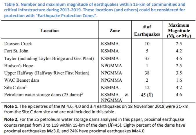
Hazard Mitigation
To carry out hydraulic fracturing operations effectively and safely, potentially destructive earthquakes must be mitigated or avoided (Atkinson et al., 2020). Hazard mitigation for induced seismicity in NEBC is predominantly through the possible varying of operator-specific practices such as the duration of injection, the injection pressure and thevolume of injected frack fluid, etc., in combination with a Traffic Light Protocol system. Despite being suggested as a mitigation approach by the BCOGC (2014), substantially modifying operator-specific HF practices to reduce earthquake inducement appears unlikely, given that a fundamental basis of the hydraulic fracturing process is to apply a high degree of brute force to create extensive fracturing in the target formation in order to generate economic petroleum production. As well, there is no documentation indicating that modified HF practices to reduce induced earthquake frequency or magnitude have been applied or tested; there is a common tendency of industry operators to hold information as proprietary where they consider that it provides a competitive advantage; and there is no regulatory requirement for modified HF practices to address earthquake risk. Given that, the primary hazard mitigation applied in NEBC is a modified Traffic Light Protocol (TLP) system. TLP systems have become the de facto mitigation approach created by regulatory agencies to address HF-induced earthquakes; despite this, little work has been done to rigorously evaluate the efficacy of their application (Schultz et al., 2020a). The primary TLP which applies to the Montney is contained within regulation under the BC Oil and Gas Activities Act, specifying suspension of HF activity if the HF well is identified as causing a seismic event of M 4.0 or greater within 3-km of the HF well (BCGOV, 2020b). The KSMMA (only 9% of the Montney) has an enhanced TLP created by Order (BCOGC 2018), specifying suspension of HF activity if a HF well is identified as causing a seismic event of M 3.0 or greater (red light), and initiating use of a mitigation plan if the HF activity is responsible for inducing an earthquake of M 2.0 or greater (orange light). Although conceptually simple and operationally easy, it is not evident that TLPs are sufficient for mitigating the potential for large magnitude induced earthquakes (Atkinson et al., 2020). A number of issues limit the benefit of the British Columbia TLP Order for the KSMMA and severely limits potential efficacy of the induced seismicity regulation (BCGOV 2020b):
- Many induced earthquakes do not have smaller precursor events that would initiate the orange light. For the 30 Montney earthquakes M≥3.0 identified as associated with proximal HF activity, only 19 (63%) have smaller precursor earthquakes (refer to Table 2). Large magnitude HF-induced earthquakes can and do occur without precursor warning.
- The TLP created under regulation (BCGOV 2020b) applies only to induced earthquakes within 3-km of the HF activity, excluding more distant earthquakes triggered by HF activity. Of the 38 M≥3.0 earthquakes listed in Table 2 where a triggering HF well can be identified, the average distance between the well and the earthquake epicentre is 5.8 km. Only 26% of the trigger wells are within 3-km of the earthquake. The MW 4.6 earthquake of 17 August 2015 in the NPGMMA was induced by Petronas fracking activity 5.1 km from the earthquake epicentre (based on the NRCAN seismographic network operating at that time). The regugation to suspend HF activity did not apply and was not applied. Petronas continued fracking a further five wells on the pad during the next three weeks, which were associated with a further nine earthquakes, including an M 3.5 on 02 September 2015.
- HF-induced earthquakes can occur distant from an initiation point due to diffusion of fluids and pore pressure increases, and induced earthquakes can have multiple companies operating in proximity concurrently. For the Montney M≥3.0 earthquakes where an apparent triggering HF well can be identified, the distance between the well and the earthquake epicentre is as great as 10+ km, and 24% of earthquakes have two or more operators fracking at the same time proximal to the epicentre, creating difficulty linking the earthquake to the initiation trigger and applying an “orange” light.
- There is considerable uncertainty and ambiguity in the locating of earthquake hypocentres in real-time that creates uncertainty in the application of a TLP based on a specified distance from a HF operation to an earthquake. For the 26 M≥3.0 earthquakes during 2014-2016 with overlapping records in the NRCAN and Visser (2017) catalogues, the distances between earthquake epicentres were 1.3-9.7 km (…). For the Mw 4.6 earthquake on 17 August 2015 the distance between the NRCAN and Visser et al. (2017) epicentres was 9.6 km. This uncertainty creates difficulties for operational decisions, difficulties for assurance of compliance and enforcement of regulations, and difficulties in determining responsibility and accountability for a damaging earthquake should that be necessary.
- Large magnitude trailing earthquakes can occur after fracking has been suspended (e.g., following the suspension of fracking with the M 4.6 earthquake on 30 November 2018, two further earthquakes occurred shortly afterwards).
Van der Elst et. al (2016) conclude that injection fluid volumes and parameters can affect the initiation of earthquakes, but that tectonics control earthquake magnitude. The upper limit of earthquake magnitude may be unbounded and determinable only within a frequency-magnitude distribution, but it should not be concluded that the largest HF-induced earthquakes that have occurred in the Montney to date are the largest earthquakes possible. The data and analysis presented in this paper show that HF-induced earthquakes increase in both frequency and magnitude in relation to frack fluid injection volumes, and that there appears to be a cumulative development effect whereby prior frack fluid injection possibly resets the seismic potential in certain tectonic environments to allow for eased earthquake initiation related to future lower volume injections. This suggests that the future in the Montney is not if M>5 earthquakes will occur, but when, with that occurrence possibly without any precursor warning.
Conclusions
Much knowledge about earthquakes induced by high volume hydraulic fracturing has been gained over the last few years, but substantial uncertainty remains. Ongoing focused
research in the direction of Atkinson (2020), Atkinson (2017), Atkinson et al. (2020), Schultz et al. (2020a, 2020b), Kao et al. (2017), Eaton and Igonin (2018), Ghofrani and Atkinson (2020), Barbaie Mahani et al. (2019), and others, is necessary. At the same time, there is clear understanding of significant public safety and infrastructure risks in the Peace River region associated with fracking, and there are clear limits and uncertainties with hazard mitigation. Enhanced hazard mitigation is necessary, including improvements in the usefulness and defensibility of the Traffic Light Protocol system used in northeast BC. The risk-informed strategy of Schultz et al. (2020b, 2021), recognizing TLP heterogeneity for at-risk population and infrastructure across the Montney may be applicable and helpful. As well, an improved TLP system would require enhanced accuracy and precision in public-facing real-time earthquake mapping.
There may be locations and values in NEBC where hazard avoidance, such as no-fracking zones, is essential and necessary (Atkinson 2017). As noted, the communities and critical infrastructure that require enhanced hazard mitigation or hazard avoidance include the communities of Dawson Creek, Fort St. John, Taylor, Hudson’s Hope, Upper Halfway (Halfway River First Nation) and possibly others, and infrastructure such as the WAC Bennett, Peace Canyon and Site C dams, water supply and treatment systems, the Taylor Gas Plant, the Taylor Bridge crossing of the Peace River, etc. This brief discussion suggests that the communities of Upper Halfway (Halfway River First Nation), Taylor and Dawson Creek (with their municipal infrastructure such as water supply and sewage treatment plants), along with the Taylor Bridge, the Taylor Gas Plant, the Site C dam and the large number of petroleum water storage dams are of particular concern for damage due to fracking-induced earthquakes. Augmented measures to provide assurance of public safety is critical.
Over the past 15 years, British Columbia’s experiment in unconventional petroleum development and large volume hydraulic fracturing of horizontal wells has led NEBC to the sobering distinction of having produced some of the world’s largest fracking-induced earthquakes. It is an issue of paramount concern.
Acknowledgements
The author is grateful for the detailed comments and suggestions provided by three anonymous reviewers, and to Laurie Lee for guiding me on a walk one midsummer morning. As well, the author is grateful to Ben, Tom and Chloe, and to colleagues for numerous discussions on this important topic. Cartography is by David Leversee.

Refer also to:
Quake Damages Photo B: Patio stones are lifting (similar damages experienced by Ann Craft from frac’ing by Quicksilver near Ponoka):
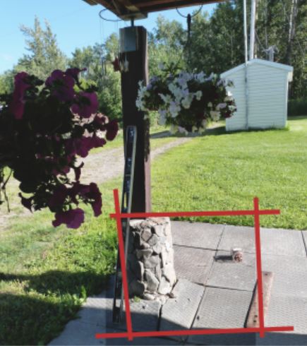
Quake C Photo: Siding on the house is buckling:

Quake D Photo: Interior home walls cracked and door ruined. No point repairing anything because the quakes keep undoing the repairs:

More damning photos at link.
2019 06 08: Vicky Simlik: Living in the middle of a gas field in Canada
2019 03 08: China Experiences a Fracking Boom, and All the Problems That Go With It
… The three earthquakes killed two people and wounded 13. More than 20,000 homes in three villages suffered damage and nine collapsed completely, according to a statement by the county. About 1,600 people were displaced….
… Meanwhile residents of Sichuan province in southwest China marched and grieved after a swarm of industry-triggered earthquakes rocked that shale gas basin on February 25.
One fracked well set off a cluster of earthquakes with magnitudes as high as 4.9 that killed two people said one report, and at least four according to another.
The tremors also damaged thousands of buildings and left hundreds homeless in Rongxian county.
In response to the quakes, thousands of angry protestors descended on government offices to demand action.
The government told the protesters it would shut down fracking operations in the region.
Seismic experts have long established that the injection of pressurized fluids into the ground over short or long periods of time can reactivate faults and cause earthquakes.
Sichuan basin, the focus of China’s shale gas fracking industry, is a densely populated area and has a grim history of tremors induced by industrial activity.
One quake triggered by the filling of dam with water, set off a massive earthquake that killed 80,000 people in 2008.
In January 2017 an earthquake triggered by China’s fracking industry damaged 571 homes.
Over the last three years fracking has triggered more than 15,000 earthquakes with magnitudes ranging up to 4.9 primarily in the Zhaotong and Changning shale gas fields of Sichuan.
One of South Korea’s largest earthquakes on record may have been caused by hydraulic fracturing – or fracking – according to a study published on Friday in the journal Science.
A magnitude-5.5 earthquake hit the south-eastern city of Pohang on 15 November, injuring at least 70 people, temporarily displacing hundreds, and causing millions of dollars of damage. …
2015 09 18: Alberta frack operation near Devon shattered home window; No wonder Edmonton-area residents are protesting fracing near their homes

And, between April 2009 and July 2011, in NEBC:
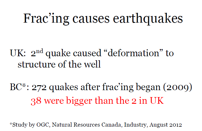
Slide from Ernst speaking events
2012: Investigation of Observed Seismicity in the Horn River Basin:
Two instances of wellbore deformation along horizontal sections were reported by one operator.
2000 04 01: Seismicity in the Oil Field
The gas field was discovered in 1956 and production began in 1962. Over the next 14 years, roughly 600×106 m3 of water, or 106 ton per km2, were injected. …
Beginning in 1976, a series of large earthquakes was recorded. The first significant earthquake occurred on April 8, 1976 at a distance of 20 km [12 miles] from the Gazli gasfield boundary. The earthquake magnitude measured 6.8.
Just 39 days later, on May 17, 1976, another severe earthquake occurred 27 km [17 miles] to the west of the first one. The magnitude of the second earthquake was 7.3. Eight years later, on March 20, 1984, a third earthquake occurred 15 km [9miles] to the west of the second earthquake, with a magnitude of 7.2. … Aftershocks occurred in a volume surrounding the three hypocentres. These earthquakes are the strongest of all the known earthquakes in the plain of Central Asia. …
There was no clear relationship between the location of the earthquake hypocenters and any previously known active tectonic structures.
Closer investigation showed that the earthquakes had created new faults.
… In all these cases, the result of human interference was to change the state of stress in the surrounding volume of earth. If the stress change is big enough, it can cause an earthquake, either by fracturing the rock mass—in the case of mining or underground explosions—or by causing rock to slip along existing zones of weakness.
The situation in regions of hydrocarbon recovery is not always well understood: in some places, extraction of fluid induces seismicity; in others, injection induces seismicity.
… Even minor actions can trigger strong seismicity.
… The amassed data indicate that the Gazli earthquakes were triggered by the exploitation of the gas field. … In regions of high tectonic potential energy, hydrocarbon production can cause severe increases in seismic activity and trigger strong earthquakes, as in Gazli, Uzbekistan.
In regions of lower tectonic stress, earthquakes of that magnitude are less likely, but relatively weak earthquakes could occur and damage surface structures.