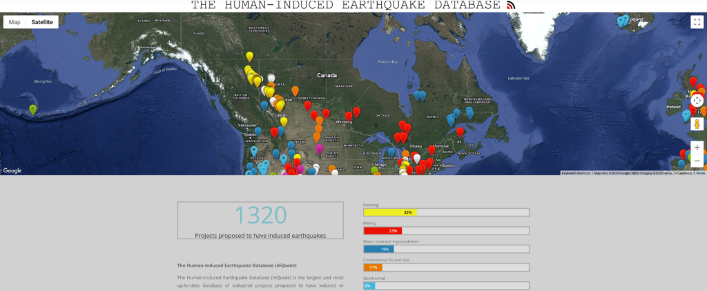
1320 Projects proposed to have induced earthquakes
The Human-Induced Earthquake Database (HiQuake)
The Human-Induced Earthquake Database (HiQuake) is the largest and most up-to-date database of industrial projects proposed to have induced or triggered earthquakes. HiQuake lists all industrial projects claimed, on scientific grounds, to have induced earthquakes. The database does not filter, rank or discriminate on the basis of the strength of the claims.
The data are freely available to download in Microsoft Excel format for your own analysis. Depending on your browser, you may need to copy the link address to a new tab and/or enable pop ups to initiate the download.
We endeavour to keep the database up to date and accurate. If you have additional cases to add to the database, more information regarding existing entries, or corrections, please contact us.
HiQuake was last updated on the 5th January 2025.
New HiQuake paper released
The HiQuake team recently published a new paper in Nature Scientific Reports titled “The plausibility of claimed induced seismicity“.
The paper applies our “Evaluating Proposals of Induced Earthquakes (E-PIE)” assessment scheme to the whole HiQuake database to initially assess the reliability of all globally known cases of proposed human-induced earthquakes. The E-PIE scores are available as Table S4 in the new paper and have also been included in the latest version of the HiQuake database.
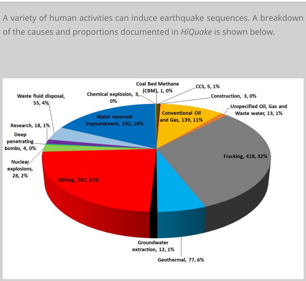
- Fracking 32%
- Mining 23%
- Water reservoir impoundment 18%
- Conventional Oil and Gas 11%
- Geothermal 6%
- Waste fluid disposal 4%
- Nuclear explosions 2%
- Research 1%
- Unspecified Oil and Gas/Waste fluid disposal 1%
- Groundwater extraction .9%
- CCS .4%
- Deep penetrating bombs .3%
- Construction .3%
- Chemical explosions .2%
- CBM .1%
What is induced seismicity? by Hiquake Team
Induced seismicity refers to seismic events (usually earthquakes) caused partially or completely by human (anthropogenic) activities.
What is the difference between “induced” and “triggered” seismicity?
Some workers distinguish between “induced” and “triggered” seismicity according to whether all or only part of the strain energy released was anthropogenic, using the term “induced” when most of the energy was anthropogenic, and “triggered” when it was predominantly of natural origin.
Determining the proportion of anthropogenic to naturally stored energy is very difficult, although in the case of larger earthquakes it is clear much of the energy is of natural tectonic origin. We use the term “induced” for both cases, which is in keeping with the convention of the Committee on Induced Seismicity Potential (Hitzman, 2013).
What human activities can induce earthquakes?
A variety of human activities have been suggested to have induced seismicity. These include impounding surface water reservoirs, erecting tall buildings, engineering coastal land accretion, and removing mass from the surface by quarrying. The subsurface extraction of resources, including groundwater, coal, hydrocarbons and geothermal fluids, as well as tunnel excavation have also been reported to induce earthquakes, as have injection activities. Injection activities include waste fluid disposal, hydrofracturing (otherwise known as hydraulic fracturing or fracking), research experiments, gas storage, enhanced oil recovery, and carbon sequestration. Nuclear tests often induce local earthquakes, though we know of no reported cases of seismicity caused by chemical explosions.
What are the mechanisms of induced seismicity?
… Below we summarise the most common anthropogenic induction mechanisms:
Increased pore fluid pressure
Increases in pore fluid pressure reduce the effective stress (σn-P) and consequently lower the shear stress needed for failure. Pore fluid pressure can be increased by the injection of fluid and the presence of surface water impoundments.
…
Increased shear stress
For faults that dip at particular angles, increases in vertical load (i.e. mass) increase the shear stress on the fault plane. This increase in shear stress may exceed the critical shear stress (Tcrit) needed for failure. Mass loading as an inducing mechanism has been proposed for skyscrapers, coastal management and surface water impoundments.
How can we mitigate against induced seismicity?
Earthquakes can pose obvious threats to engineering works and to human life. In order to protect people, infrastructure and the environment, a number of common practices can be employed to reduce the risk:
…
“Traffic light” systems
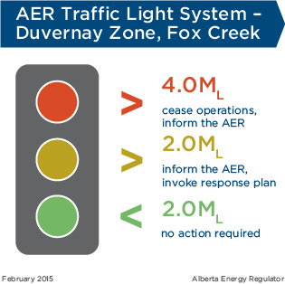
As well as local baseline seismic monitoring prior to the start of a project, seismic monitoring can also be undertaken throughout a project’s lifetime. A user-friendly format is the traffic light system, where predefined seismic magnitudes correspond to the traffic light colours. If these magnitudes are exceeded this may result in the modification or termination of a project. Green means the project continues as planned, orange may mean the project continues at reduced rates (modification), and red may mean an immediate halt in the project.
An example is the UK traffic light system for shale gas hydrofracturing.
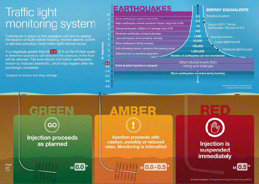

![]() Compare the UK’s reasonable and wise traffic light mitigation, where 0.5M results in immediate suspension, with Alberta’s, where operations are not stopped until injection/frac’ing causes earthquakes larger than 4.0ML:
Compare the UK’s reasonable and wise traffic light mitigation, where 0.5M results in immediate suspension, with Alberta’s, where operations are not stopped until injection/frac’ing causes earthquakes larger than 4.0ML:
@hellobarbie.bsky.social:
Alberta’s earthquakes must be having serious impacts too.
flyflicker.bsky.social @flyflicker.bsky.social:
Totally unconnected, but the southcoast of BC and Vancouver area experienced a 5.4 earthquake yesterday – the first in many years.
Or … WAS it unconnected??
‘Really fed up’: B.C. ranchers say fracking-induced earthquakes hurt cattle, Fifteen recent earthquakes in five days, linked to fracking, are having serious implications for ranchers — including livestock stress, premature births and water shortages by Sarah Cox, Feb. 22, 2025, The Narwhal
H. Owlett (radical feminist) @hedwigowlett.bsky.social:’
We are going to frack the whole planet from under us, because the rich want more money.
dumbarse.bsky.social @dumbarse.bsky.social:
Yes, the greed is full on in BC, the water use in this industry is criminal, fresh to chemical soup, of no use anymore.
Aaron @ask70.bsky.social:
Weird to think pumping brake fluid into the ground would cause problems
‘Big rumble’: 5.4 quake rolls over B.C. coast, in ‘wake-up call’ for larger tremor, Natural Resources Canada says the quake was centred 24 kilometres north-northeast of Sechelt on the Sunshine Coast by Nono Shen and Brenna Owen, The Canadian Press, Feb. 21, 2025, Toronto Star
![]() Was it triggered or induced by the frac quakes in Alberta the day before?
Was it triggered or induced by the frac quakes in Alberta the day before?![]()
VANCOUVER – A 5.4-magnitude earthquake rocked British Columbia’s southwest coast on Friday, shaking up residents, and issuing a reminder that the area is seismic zone.
Natural Resources Canada said the quake was centred 24 kilometres north-northeast of Sechelt on the Sunshine Coast and while it originally set the quake’s magnitude at 5.1, it upgraded it later on Friday.
It said the earthquake occurred at 1:26 p.m. local time on Friday, at a depth of about one kilometre, and there were no reports of damage.
However the quake shook major population centres including Metro Vancouver and Victoria for several seconds and was felt as far away as Prince George in central B.C., about 800 kilometres away.
The U.S. National Tsunami Warning Center said there was no risk of a tsunami.
Karen Weissenborn was working at a gift store near the epicentre in Sechelt when the earthquake triggered the store’s alarm.
She said the shaking started as mild and then got more intense, and her first reaction was thinking that a “truck has slammed into the wall.”
Brynn Campbell was working at a clothing store in Sechelt.
“It was like a big rumble, yeah, and the glass was shaking. That was wild,” said Campbell.
“At first we thought it was like construction or something, to be completely honest. And then we kind of were like, ‘Oh no, no, no. That was an earthquake.’ ”
Campbell said there was no damage at the store.
The quake did not result in alerts from the province’s Earthquake Early Warning system for most areas that felt it.
Alison Bird, a seismologist with Natural Resources Canada, said alerts were only issued in an area around the epicentre, where “strong shaking” was anticipated.
Taimi Mulder, another Natural Resources Canada seismologist, said B.C. has been “overdue” for a larger earthquake since 1946, when a magnitude-7.3 quake struck the Courtenay area on Vancouver Island.
“It’s definitely a really good wake-up call that we all need to be prepared,” she said of Friday’s quake.
“Mentally, be prepared that we could have a large earthquake and that they really do happen here. Second of all, know what to do when you experience an earthquake, so for instance, that would be drop, cover, and hold on.”
Mulder said information about Friday’s quake was still preliminary and more details would be confirmed throughout the day.
The offshore earthquake often dubbed “the big one” has a recurrence interval of about 250 to 800 years, with the last one recorded 325 years ago, she said. “So we’re in the time window between now and the next 500 years for another one of those.”
John Cassidy, another seismologist with Natural Resources Canada, said shallow earthquakes typically bring aftershocks that may or may not be felt in the coming days.
BC Ferries issued a travel advisory Friday saying there may be sailing days for the Horseshoe Bay and Langdale terminals as its teams conduct inspections on terminal infrastructure following the earthquake. Langdale is about 30 kilometres from Sechelt.
The City of Vancouver issued a statement saying the quake set off a “Level 1 response,” which includes immediate inspection of bridges by the city’s structural engineering consultants.
Reports from Earthquakes Canada and the U.S. Geological Survey said many thousands reported feeling the quake, with most saying it was of light to moderate intensity.![]() Copy of the felt reports list below
Copy of the felt reports list below![]()
The operator of E-Comm, the 911 service provider for British Columbia, issued a news release Friday reminding people who felt the quake that their call centre is for emergencies only.
On Thursday, a 5.2-magnitude earthquake was detected roughly 63 kilometres northeast of Grande Cache, Alta., but it wasn’t believed to have caused any damage.
Last week a string of much smaller quakes shook B.C., including a 3.8-magnitude tremor off the southern coast that was felt across southern Vancouver Island.![]() Waste injection and frac’ing has been inducing many quakes for weeks at Musreau Lake, Alberta which might have induced these earlier quakes on the coast.
Waste injection and frac’ing has been inducing many quakes for weeks at Musreau Lake, Alberta which might have induced these earlier quakes on the coast.![]()
Earthquakes Canada says shaking from an earthquake increases about 10 times for each whole increase in magnitude; for instance a magnitude-6 quake is felt 10 times more strongly than a magnitude-5 quake.
It says it is “very unlikely that an earthquake of magnitude less than 5 could cause any damage.”
![]() Why the hell do Canadian authorities keep downplaying the risks and harms caused by waste injection and frac’ing induced quakes? Many quakes smaller than 5M have caused serious damages in Gronigen NL, the USA, Canada and elsewhere. The 4.6M quake induced by Vesta near Red Deer Alberta caused significant property damages. The 4.7M on the BC coast (see article below) caused burst pipes which is bloody serious and life threatening if those pipes were transporting gas.)
Why the hell do Canadian authorities keep downplaying the risks and harms caused by waste injection and frac’ing induced quakes? Many quakes smaller than 5M have caused serious damages in Gronigen NL, the USA, Canada and elsewhere. The 4.6M quake induced by Vesta near Red Deer Alberta caused significant property damages. The 4.7M on the BC coast (see article below) caused burst pipes which is bloody serious and life threatening if those pipes were transporting gas.)![]()
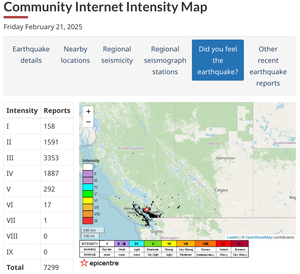
Snap taken Feb 26, 2025 from Earthquakes Canada:
Feb 21, 2025: 7,299 felt reports for 4.7M, 1km deep, earthquake on BC coast.
![]() One day earlier, the 5.03M earthquake hit Musreau Lake (Grande Cache) area which is heavily frac’d and has waste injection wells (10 million cubic metres of waste injected as of 2022; hundreds of thousands of cubic metres injected daily). In 2023, researchers forecast an induced 5M earthquake from waste injection!
One day earlier, the 5.03M earthquake hit Musreau Lake (Grande Cache) area which is heavily frac’d and has waste injection wells (10 million cubic metres of waste injected as of 2022; hundreds of thousands of cubic metres injected daily). In 2023, researchers forecast an induced 5M earthquake from waste injection!![]()
Data below of some of the area quakes from AER’s earthquake dashboard (which moves terribly slowly):
SI = Suspected Induced
KI = Known Induced
![]() Many more quakes since the big 5.03 on Feb 20. Either Danielle Smith’s pal she plunked onto the AER did not shut down the frac’er as required under the traffic light system, or, they were shut down, but the frac quakes continued.
Many more quakes since the big 5.03 on Feb 20. Either Danielle Smith’s pal she plunked onto the AER did not shut down the frac’er as required under the traffic light system, or, they were shut down, but the frac quakes continued.![]()
23 Feb 2025 5km depth 2.39 KI 26 km SSE of Musreau Lake AB
23 Feb 2025 7km depth 1.55 KI 24 km SSE of Musreau Lake AB
23 Feb 2025 5km depth 1.68 KI 5 km E of Musreau Lake AB
23 Feb 2025 4km depth 1.32 KI 22 km S of Musreau Lake AB
23 Feb 2025 4km depth 1.3 KI 24 km S of Musreau Lake AB
23 Feb 2025 3km depth 1.38 KI 22 km SSE of Musreau Lake AB
22 Feb 2025 4km depth 1.01 SI 9 km N of Musreau Lake AB
22 Feb 2025 4km depth 1.11 KI 24 km S of Musreau Lake AB
22 Feb 2025 4km depth 1.49 KI 20 km S of Musreau Lake AB
22 Feb 2025 4km depth 1.32 KI 23 km S of Musreau Lake AB
22 Feb 2025 4km depth 1.06 KI 19 km S of Musreau Lake AB
22 Feb 2025 4km depth 1.61 KI 23 km S of Musreau Lake AB
21 Feb 2025 4km depth 1.56 KI 26 km SSE of Musreau Lake AB
21 Feb 2025 9km depth 1.76 KI 24 km SSE of Musreau Lake AB
21 Feb 2025 4km depth 1.23 KI 24 km S of Musreau Lake AB
21 Feb 2025 11km depth 1.82 KI 23 km SSE of Musreau Lake AB
21 Feb 2025 4km depth 1.2 KI 23 km S of Musreau Lake AB
21 Feb 202 12km depth 1.74 KI 24 km SSE of Musreau Lake AB
21 Feb 2025 6km depth 1.25 KI 25 km S of Musreau Lake AB
20 Feb 2025 8km depth 3.59 KI 25 km SSE of Musreau Lake AB
20 Feb 2025 4km depth 2.4 KI 25 km SE of Musreau Lake AB
20 Feb 2025 5km depth 2.65 KI 24 km S of Musreau Lake AB
20 Feb 2025 5km depth 2.11 KI 24 km SSE of Musreau Lake AB
20 Feb 2025 8km depth 2.54 KI 24 km SSE of Musreau Lake AB
20 Feb 2025 7km depth 3.03 KI 25 km S of Musreau Lake AB
20 Feb 2025 7km depth 1.84 KI 23 km S of Musreau Lake AB
20 Feb 2025 5km depth 5.03 SI 24 km S of Musreau Lake AB * THE BIG ONE *
17 Feb 2025 4km depth 1.16 KI 26 km SSE of Musreau Lake AB
17 Feb 2025 4km depth 1.34 KI 25 km SSE of Musreau Lake AB
17 Feb 2025 4km depth 1.14 KI 27 km SSE of Musreau Lake AB
17 Feb 2025 4km depth 1.19 KI 26 km SSE of Musreau Lake AB
16 Feb 2025 4km depth 1.14 KI 24 km SSE of Musreau Lake AB
16 Feb 2025 4km depth 1.34 KI 23 km S of Musreau Lake AB
…
13 Feb 2025 8km depth 3.01 KI 25 km SSE of Musreau Lake AB
13 Feb 2025 8km depth 2.65 KI 28 km SSE of Musreau Lake AB
13 Feb 2025 5km depth 2.72 KI 9 km N of Musreau Lake AB
…
12 Feb 2025 5km depth 2.79 KI 437629 11 km NNE of Musreau Lake AB
12 Feb 2025 7km depth 2.56 KI 25 km NNW of Musreau Lake AB
…
11 Feb 2025 7km depth 3.11 KI 25 km SSE of Musreau Lake AB
…
02 Feb 2025 4km depth 2.27 KI 25 km SSE of Musreau Lake AB
…
![]() etc etc etc etc many more pages of known induced quakes where heavy frac’ing is ongoing in the area of these reported fracquakes in the Musreau Lake/Grande Cache area.
etc etc etc etc many more pages of known induced quakes where heavy frac’ing is ongoing in the area of these reported fracquakes in the Musreau Lake/Grande Cache area.![]()
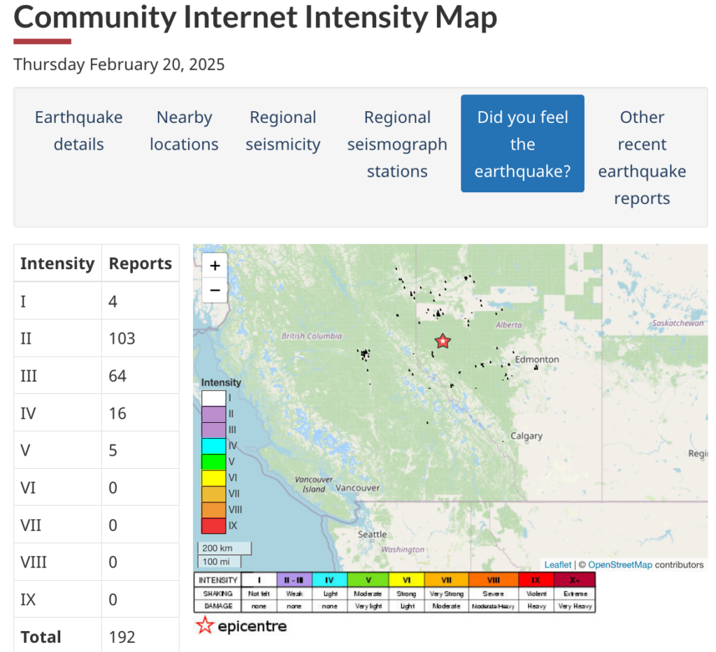
Feb 20, 2025: 192 felt reports for the 5.03M frac/waste injection earthquake at Musreau Lake (near Grande Cache) Alberta
Shaking felt across southwest B.C. after 4.7-magnitude earthquake hits coast, No major damage, no tsunami threat after shaking on Friday by Rhianna Schmunk, Feb 21, 2025, CBC News
A minor earthquake struck B.C.’s Sunshine Coast on Friday, shaking homes and prompting a number of emergency alerts across the Lower Mainland but stopping short of any major damage.
The 4.7-magnitude earthquake hit near the seaside community of Sechelt just before 1:30 p.m. PT, according to Earthquakes Canada.
Despite being widely felt from Vancouver Island to Metro Vancouver and the Fraser Valley, officials said nobody reported any injuries or structural issues aside from some cracking drywall or burst pipes.
A number of people said it was the most prominent earthquake they’d experienced in some time.
“I heard a loud boom, I felt the house shake,” said Jackie Graham, who lives on the banks of the Puntledge River in Courtenay, a Vancouver Island city to the west of Sechelt.
“My first thought was that a tree had fallen on the house.”
Earthquakes Canada initially recorded the magnitude as high as 5.4 but revised the measurement to a lower 4.7 around 5 p.m. PT— which means it is classified as a minor event.
Adults at work and children in schools said they jumped under their desks once they realized the ground was shaking, as they’d practised in earthquake drills. Others grabbed their pets and wallets before running outside.
The manager of an IGA grocery store in Sechelt said staff and customers hustled out of the building.
“In the past, we’ve had someone drive into the mall, and it was a similar feeling, but it slowly increased. And it lasted what felt like, yeah, 10 to 20 seconds,” Derek Bland told CBC News. “So everyone kind of shuffled to the front door frame and made their way out, went to our muster station in the middle of the parking lot.”
B.C. Ferries briefly evacuated and inspected its Horseshoe Bay terminal in West Vancouver, which is a major link between the mainland, Vancouver Island and the Sunshine Coast.
“Inspections have now been completed, and customers and staff are returning to the terminal. Safety is always our top priority, and we appreciate everyone’s patience during this process,” read a statement, which warned some sailings might be delayed.
Shaking was felt as far east as Peachland, in B.C.’s Okanagan, and down to parts of Washington state.
It triggered the Canadian Earthquake Early Warning (EEW) system, which gives people a few extra moments’ notice before strong shaking hits their area. It’s an alert sent to local cell towers, radios and TVs automatically, so it should reach locals and visitors as long as they’re in the zone — no need to sign up.
People who are further from the epicentre shouldn’t expect an EEW alert since it’s only for areas where the shaking could hurt someone. In an email, Natural Resources Canada said it would be investigating reports from people who did not receive alerts as they should have on Friday.
The U.S. Geological Survey (USGS) measured the earthquake at magnitude 4.8. There are often discrepancies between Canadian and American seismographs as experts work to confirm official numbers.
Earthquakes Canada said a magnitude-1.9 aftershock hit at 2:40 p.m. PT.
Sheri Molnar, an associate professor at Western University in London, Ont., who studies seismic activity in Metro Vancouver, said the region experiences what’s called a “felt earthquake” every decade or so — pointing to the 4.7-magnitude earthquake near Sidney on Dec. 29, 2015, and the 6.8-magnitude Nisqually earthquake on Feb. 28, 2001.
“You should always be ready for an earthquake. We’re not ready for a very strong earthquake and we’re not ready for an earthquake that would cause damage … but it can happen,” Molnar said.
Emergency Info B.C., the provincial government organization that offers updates during crises, said there was no tsunami threat. Officials from various levels of government across the province said the earthquake should serve as a reminder to prepare an emergency kit and create a family plan.
In Fault Lines, seismologist Johanna Wagstaffe takes you through two disastrous scenarios so you can prepare yourself, your family, and your neighbours in the event of an earthquake. Download Fault Lines now on CBC Listen, Apple Podcasts and Google Podcasts.
![]()
![]()
![]() A bit of quake triggering history:
A bit of quake triggering history:![]()
![]()
![]()
“Jumpstart
Earthquake insurance for everyone.”
En echelon faults reactivated by wastewater disposal near Musreau Lake, Alberta by by Ryan Schultz, Yongsoo Park, Albert Leonardo Aguilar Suarez, William L Ellsworth, Gregory C Beroza, Geophysical Journal International, Volume 235, Issue 1, October 2023, Pages 417–429,
https://doi.org/10.1093/gji/ggad226
SUMMARY
We use machine-learning and cross-correlation techniques to enhance earthquake detectability by two magnitude units for the earthquake sequence near Musreau Lake, Alberta, which is induced by wastewater disposal. This deep catalogue reveals a series of en echelon ∼N–S oriented strike-slip faults that are favourably oriented for reactivation. These faults require only ∼0.6 MPa overpressure for triggering to occur. Earthquake activity occurs in bursts, or episodes; episodes restricted to the largest fault tend to have earthquakes starting near the southern end (distant from injectors) and progressing northwards (towards the injectors). While most events are concentrated along these ∼N–S oriented faults, we also delineate smaller faults. Together, these findings suggest pore pressure as the triggering mechanism, where a time-dependent increase in pore pressure likely caused these faults to progressively reawaken. Analysis of the ‘next record-breaking event’, a statistical model that forecasts the sequencing of earthquake magnitudes, suggests that the next largest event would be ML ∼4.3.
The seismically illuminated length of the largest fault indicates potential magnitudes as large as Mw 5.3.
How A Major Earthquake Affects You Hundreds Of Miles Away by Jump Start Insurance,
If a major earthquake hits in Southern California, does that mean an earthquake will soon happen in Northern California, and vice-versa? How worried should I be when a major earthquake occurs hundreds of miles away from me? Read on to learn more about fault lines and what the experts say.
Moving Fault Lines
We often start thinking about earthquakes just after a major earthquake occurs somewhere else. That’s a great moment to prepare because a major earthquake hundreds of miles away could trigger an earthquake near you.
Really? Yes…
When a major earthquake happens on one fault line, it affects other faults, even ones that are hundreds of miles away. The earth’s tectonic plates are like a bath filled with rubber ducks. If one duck moves, all the others move – at least a little. Earth’s floating tectonic plates are similar, but a lot more complex. The edges of the earth’s tectonic plates are not smooth like a rubber duck, so the movement of the plates is not as easily transferred. Crags and irregularities in the bedrock create friction that prevents the plates from sliding smoothly.
Movement at one fault line causes stresses to be distributed to a different part of the fault line and nearby fault lines, either adding stress or reducing stress. The earthquake reduces stress on the fault line in the ruptured region and at nearby parallel fault lines. The energy of the earthquake dissipates built-up frictional energy, which means that, after the initial aftershocks, another large earthquake is not likely in the immediate vicinity. But beyond the ruptured region, where there wasn’t a slip, the fault stress increases, leading to a greater probability of an earthquake.
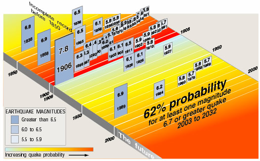
1906 San Francisco Great Earthquake
Scientists understood this post-earthquake energy release and distribution from the 1906 San Francisco earthquake. The 60-second long, M7.8 earthquake was so large that it reduced all earthquake stresses on the SF Bay Area’s many fault lines and led to a “quiet” period. See the timeline below, showing the earthquake lull between 1906 and 1989.
Earthquakes Triggered Thousands of Miles Away
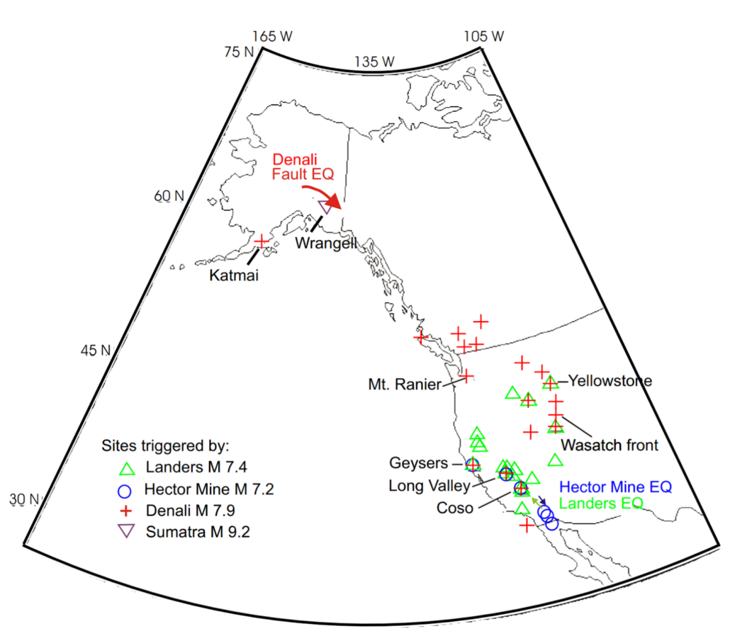
Did the 2019 Ridgecrest earthquake trigger minor earthquakes near Seattle, Washington and in the SF Bay Area? Or, would the M4.3 and M.4.6 earthquakes have occurred at that time anyhow? Major earthquakes not only affect areas that are hundreds of miles away, but also thousands of miles away. If a fault is already at the brink of its stress capability, it can be tipped over the edge by a major earthquake thousands of miles away. This is called “dynamic triggering.” Experts at the United States Geological Survey (USGS) state there’s “evidence that some major earthquakes manage to trigger seismicity over much greater distances (thousands of miles), but these triggered quakes are small and very short lived.” The M7.9 Denali Fault, Alaska earthquake in 2002 is a well-known example of dynamic triggering. The earthquake triggered 19 other earthquakes from Alaska to San Diego, California, roughly 2,300 miles away. See the red crosses below for for the Denali Fault dynamic triggering.
The Next Major Earthquake
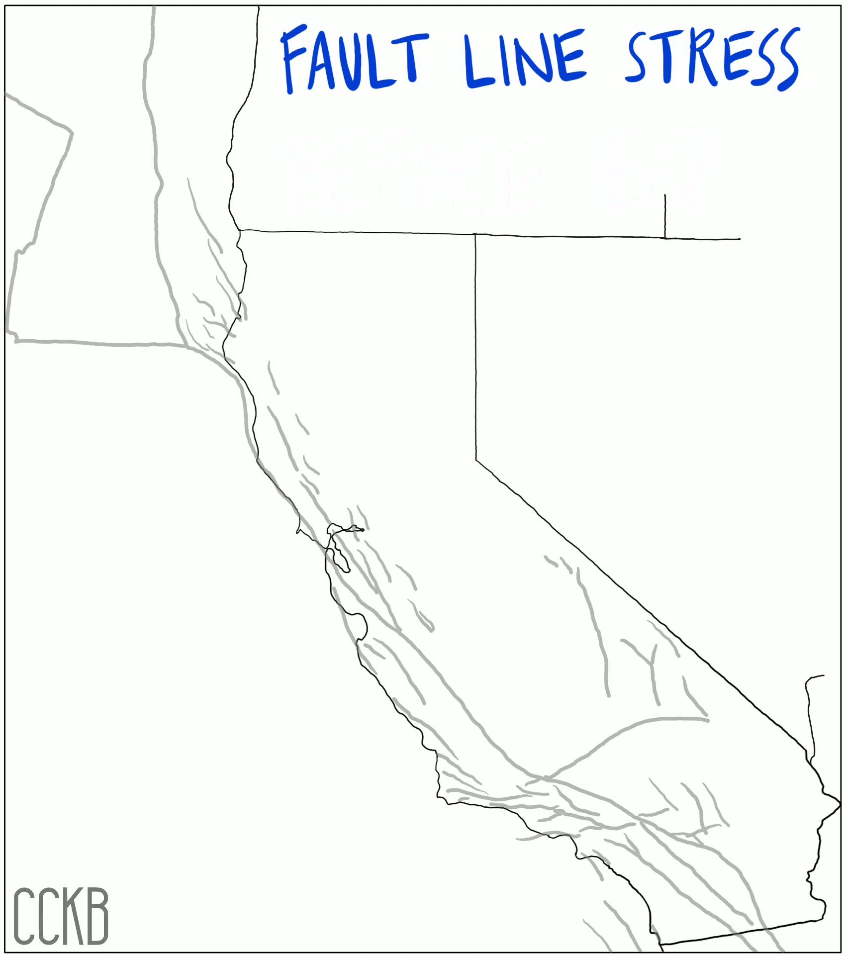
When we feel the slight shaking of a nearby M4.0 earthquake, we start wondering if it’s a foreshock to something bigger. But, larger earthquakes farther away could also be a clue to future shaking. This is especially true in California where many fault lines are waking up from their lull and approaching their tipping points. Check out Are We Due for a Big One, for a fault line basics refresher.
Research finds quakes can systematically trigger other ones on opposite side of Earth by Oregon State University, Aug. 1, 2018

Editor’s note: This is a revised version of the press release.
New research shows that a big earthquake can not only cause other quakes, but large ones, and on the opposite side of the Earth.
The findings
(Link is external), published Aug. 2 in Nature Scientific Reports, are an important step toward improved short-term earthquake forecasting and risk assessment.
Scientists at Oregon State University looked at 44 years of seismic data and found clear evidence that temblors of magnitude 6.5 or larger trigger other quakes of magnitude 5.0 or larger.
It had been thought that aftershocks – smaller magnitude quakes that occur in the same region as the initial quake as the surrounding crust adjusts after the fault perturbation – and smaller earthquakes at great distances – were the main global effects of very large earthquakes.
But the OSU analysis of seismic data from 1973 through 2016 – an analysis that excluded data from aftershock zones – using larger time windows than in previous studies, provided discernible evidence that in the three days following one large quake, other earthquakes were more likely to occur.
Each test case in the study represented a single three-day window “injected” with a large-magnitude (6.5 or greater) earthquake suspected of inducing other quakes, and accompanying each case was a control group of 5,355 three-day periods that didn’t have the quake injection.
“The test cases showed a clearly detectable increase over background rates,” said the study’s corresponding author, Robert O’Malley, a researcher in the OSU College of Agricultural Sciences. “Earthquakes are part of a cycle of tectonic stress buildup and release. As fault zones near the end of this seismic cycle, tipping points may be reached and triggering can occur.”
The higher the magnitude, the more likely a quake is to trigger another quake. Higher-magnitude quakes, which have been happening with more frequency in recent years, also seem to be triggered more often than lower-magnitude ones.
A temblor is most likely to induce another quake within 30 degrees of the original quake’s antipode – the point directly opposite it on the other side of the globe.
“The understanding of the mechanics of how one earthquake could initiate another while being widely separated in distance and time is still largely speculative,” O’Malley said. “But irrespective of the specific mechanics involved, evidence shows that triggering does take place, followed by a period of quiescence and recharge.”
Earthquake magnitude is measured on a logarithmic 1-10 scale – each whole number represents a 10-fold increase in measured amplitude, and a 31-fold increase in released energy.
The largest recorded earthquake was a 1960 temblor in Chile that measured 9.5. The 2011 quake that ravaged the Fukushima nuclear power plant in Japan measured 9.0.
In 1700, an approximate magnitude 9.0 earthquake hit the Cascadia Subduction Zone – a fault that stretches along the West Coast of North American from British Columbia to California.
Collaborating with O’Malley were Michael Behrenfeld of the College of Agricultural Sciences, Debashis Mondal of the College of Science and Chris Goldfinger of the College of Earth, Ocean and Atmospheric Sciences.
Big Quakes Can Trigger Other Shakes Thousands of Miles Away, According to new research, when a big one strikes, more than aftershocks can follow by Jesse Emspak, October 16, 2015, Smithsonian
On April 11, 2012, an 8.6 magnitude earthquake in the Indian Ocean shook the Sumatran coast. Only a day later—3,900 miles (6,230 km) away—seismologists detected a set of smaller temblors rattling the eastern coast of Japan.
But this was no aftershock, those smaller rumblings that usually occur in the aftermath of an intense seismic event. Yet the two quakes may still have been related, according to a team of researchers from Los Alamos National Laboratories.
Earthquakes happen when pieces of the Earth’s crust slip by each other, are stretched, or compressed. The points of contact are called faults (essentially, cracks). The stress builds and is eventually released, resulting in a sudden movement. After an earthquake, the affected region may, of course, experience aftershocks. For example, the Tohoku earthquake of 2011 moved parts of Honshu Island a full 13 feet closer to the U.S.
According to the research published today in the journal Science Advances, large quakes can also set set off smaller ones on a distant part of the globe by altering the way the rock responds to stress.
“In any kind of fault, you have everything from fractured rock to granular material,” says Andrew A. Delorey, a geophysicist at Los Alamos National Laboratories who led the recent study. “When you shake that up, the way force is transmitted through it will change.”
Whether a distant, large earthquake will trigger another fault the way the Indian Ocean quake did in Japan depends on a number of factors: The amount of activity that has already occurred, stress the fault has already endured and the kind of material in the fault itself.
Earthquakes and faults come in several varieties. At the boundaries between plates, faults generate quakes because the plates don’t always smoothly slip by each other. In California and in the Indian Ocean off Sumatra, the plates slide against each other laterally; this is known as a strike-slip fault. In Japan, the Pacific plate is being driven underneath the one that carries the main islands, and that boundary is a convergent-type fault.
The area Delorey studied consists of so-called “normal” faults, which are areas the crust is stretching out and breaking, and the two sides of he fault are moving up and down relative to each other.
An earthquake sends seismic waves through the surrounding rock, and those waves can, and do, travel great distances. (This is one reason seismic detectors can pick up both earthquakes and nuclear weapons tests even when they are very far away). The Los Alamos study posits that those waves jostle the rocks in the areas immediately around faults, as well as the faults themselves, changes the way the material in the fault responds to stress.
A good analogy is a pile of gravel: Depending on its initial shape, the form it takes after you shake it will differ and with it, the way it would transmit force, Delorey says.
If there has been a lot of recent seismic activity in an area with faults, those faults can be put under more stress very quickly—this is what happened in Japan. An additional seismic wave can push them over the top so that they slip, causing a secondary earthquake.
In this case, the seismic wave from the Indian Ocean Earthquake hit the already stressed rock of Japan, which had experienced the 9.0 magnitude Tohoku quake only a year before.
In the study, Delorey’s team looked at two small earthquakes that occurred just off the eastern coast of Japan 30 and 50 hours after the Indian Ocean quake. The temblors themselves were relatively mild, magnitude 5.5 and 5.7, respectively—people on shore wouldn’t have noticed them.
The quakes occurred in a line, one after the other, describing a path that led right back to the Indian Ocean quake’s epicenter. But the odds were against that pattern, with a chance of only 1 in 358 that they would happen coincidentally, according to the study.
The team also found that seismic activity in that area generally showed a sharp increase just after the Indian Ocean quake, which tailed off after several days. Delorey notes that he happened to study the area near Japan because the seismic monitoring there is exceptionally good, but if his hypothesis is correct, the same thing would show up elsewhere in the world.
Delorey’s study isn’t the first time that anyone has theorized large quakes causing smaller cascading ones, but it has never been directly measured.
This does not mean that a quake in Sumatra—or anywhere else—would necessarily cause problems for residents of California, for example, nor does it mean that a distant quake will always cause smaller ones somewhere else. Changes to the faults are also not permanent. The faults can recover their strength and resistance to slippage after weeks or months. It doesn’t even make an area more prone to shaking, explains Delorey. “It depends on the properties of the material.”
The real benefit of knowing this happens is learning about the structure of faults. Large seismic waves can act like radar—by studying what happens to them before and after they trigger earthquakes elsewhere, it’s possible to see the structure of a fault system more clearly. “If we do see triggered quakes we can learn something about stresses on that fault,” Delorey says. “We really don’t have a good handle on temporal changes in response to seismic hazards. These [studies] can get us a bit closer.”
Can big quakes trigger others far away? by Nicola Jones, 19 April 2013, New Scientist
Big earthquakes cause other quakes far away at least 9 per cent of the time. That’s the conclusion of a new statistical analysis, one that will add to the debate about whether big quakes can trigger damaging tremors elsewhere, and the mechanism that could allow that to happen.
A spate of huge earthquakes in recent years – in Sumatra, Indonesia, in December 2004, Chile in February 2010, and Japan in 2011 – caused many to question whether one large quake can cause another on the other side of the world.
Tom Parsons of the US Geological Survey in Menlo Park, California, surveyed catalogues of seismic activity on every continent except Antarctica, going back to 1979. Over the period, there were 260 earthquakes of magnitude 7 or greater. Twenty-four were followed by small earthquakes on separate fault systems, as the seismic waves passed through distant lands. “It’s a small hazard, but there is a risk,” he says.
His data suggest that any given region will be hit by an earthquake as a result of 2 per cent of big earthquakes elsewhere in the world. Parsons presented his results today at the Seismological Society of America annual meeting in Salt Lake City, Utah.
He was keen to see if any quakes of magnitude 5 or larger – which can cause serious damage – were the result of remote seismic activity. He found seven events that might qualify, but they all happened at least 9 hours after the seismic waves had passed through those regions, making it hard to say what caused them. “We still can’t say whether they’re linked,” says Parsons.
“If there’s always a persistent time lag,” he adds, “maybe that tells you something interesting about these earthquakes. Maybe you always have to wait at least nine hours.”
A recent study of the 2012 Indian Ocean megaquake linked it to a fivefold increase in magnitude 5.5 or greater quakes the world over, for up to a week following the tremor. The activity was so unusual that the researchers could make a convincing case that they were caused by the megaquake, says David Hill, also at the USGS in Menlo Park.
So far, geologists can only speculate about how one quake might trigger another with such long time delays.
Messing up the plumbing
One idea is based on the fact that earthquakes can change the fluid plumbing in a distant region. For instance, “You can have an earthquake in Alaska and someone’s well in Florida will dry up,” says Parsons. We also know that changes in subterranean water pressure can affect the friction on a fault, so it’s conceivable that this could help remotely trigger earthquakes with a delay of hours or days.
Hill notes that geothermal and volcanically active areas like The Geysers, a geothermal development in California, are particularly susceptible to rumbling after the waves of distant earthquakes have passed through.
Parsons says his next step will be to investigate the 24 quakes that caused far-off events and see if there is anything special about them. “So far they look fairly ordinary. So we’re going to have to really dig into them,” he says.
Large Earthquakes Can Trigger Later Tremors Many Miles Away by Sandra Blakeslee, June 29, 1993, New York Times
LARGE earthquakes can trigger tiny ones hundreds of miles away hours, days and even weeks later, scientists say.
Such remote earthquakes are small and pose no danger to people or structures, the researchers said, but they do raise profound questions about the causes of earthquakes and the hidden structures within the earth’s crust.
Earthquakes typically produce aftershocks near their epicenter and sometimes cause adjacent faults to fail, said Dr. Paul Reasenberg, a geophysicist at the United States Geological Survey in Menlo Park, Calif. When people advanced the idea that earthquakes occurring hundreds of miles apart on different days were related, he said, scientists were skeptical.
“But now we’ve been hit over the head with observations we cannot ignore,” he said. “We are being forced to look for new mechanisms” to explain earthquakes.
A report on those mechanisms, appearing in a recent issue of the journal Science, involves the possible interaction of seismic waves with fluids trapped underground.
The turnaround in thinking came on the heels of a strong earthquake last year in southern California, said Dr. David Hill, a geophysicist at the Geological Survey and the lead author of the report. Before dawn on June 28, an earthquake that measured 7.3 on the Richter scale struck near the small town of Landers and ripped northward into the Mojave Desert, moving the ground up to 12 feet. It was the largest earthquake to strike the region in 40 years.
Seismic waves were focused northward, Dr. Hill said, and within minutes, earthquake activity increased abruptly all over the West.
Numerous Quakes Triggered
Swarms of small earthquakes were detected all along the eastern boundary of the Sierra Nevada, particularly in volcanic and geothermal areas that dot the region. The ground trembled as far as 750 miles away, in Mount Lassen in northern California, Cascade in western Idaho and Yellowstone National Park in Wyoming.
A day after the Landers earthquake, a cluster of small earthquakes occurred in Pasadena, more than 40 miles away. Later that day, a magnitude 5.6 earthquake struck 144 miles away in southern Nevada at a wilderness site called Little Skull Mountain, a stone’s throw from a proposed underground nuclear waste storage facility. It was the largest earthquake in that region since 1868.
The triggered quakes began 30 seconds to 33 hours after the main shock at Landers, Dr. Hill said. At some sites, the increased activity lasted for three weeks or more. In general, the size of these triggered quakes decreased with distance from Landers.
Ten years ago it would not have been possible to see the links between all these earthquakes, Dr. Hill said. But a growing network of seismographs and other instruments in the West can now detect and help analyze such events.
The scientists noticed several things right away. Most of the activity lay to the north. All faults that broke were aligned in roughly the same direction. Some of the triggered sites were within geothermal or volcanic areas. And the tiny earthquakes usually began soon after a particularly large seismic wave passed through the region.
Earthquakes produce many kinds of seismic waves, Dr. Hill said. The biggest is the so-called surface wave that arrives 5 to 20 seconds after the initial waves pass by. In a large earthquake like the one at Landers, the surface wave can have an amplitude of 12 to 15 miles, Dr. Hill said, so it undulates through the entire depth of earth’s crust. Role of Underground Water
In some places faults have built up stresses and are poised to fail, Dr. Reasenberg said. But other areas do not begin to produce earthquakes until several days have passed, he said. This is where the fluids come in.
In volcanic and geothermal areas, the giant seismic wave may interact with magma to liberate gas bubbles, Dr. Reasenberg said. The bubbles rise but are trapped in a chamber of magma. The resulting pressure deforms overlying rock and causes earthquakes.
In other regions, tiny pockets of water may be trapped in veins deep in the crust, sealed under high pressure for thousands of years. When the large earthquake wave comes through, Dr. Hill said, the seals may be broken so that fluid moves from one part of the crust to another. This change in pressure may destabilize a nearby earthquake fault, allowing it to rupture. Under certain conditions, he said, the fluids would move slowly, so earthquakes continue for days and weeks.
Shifts in high-pressure fluid could be a major cause of earthquakes, Dr. Hill said. The idea makes sense given a recent finding that faults are much weaker than people thought and do not seem to build up the huge frictional forces invoked to explain why the earth snaps.
Not all large earthquakes will trigger remote earthquakes, Dr. Hill said. A magnitude 7.1 earthquake struck near the California-Oregon border 64 days before the Landers quake, he said, but its seismic waves propagated into the deep ocean. The magnitude 6.9 Loma Prieta earthquake near San Franscisco in 1989 triggered activity in the Geysers area 130 miles away but not elsewhere, he said. But after the devastating 1906 San Francisco earthquake, people reported feeling eight earthquakes up to two days later 420 miles north and south of the city.
Seismologists are scrambling to explain the phenonomenon, said Paul Segall, a geophysicist at Stanford University and the Geological Survey. “Whoever cracks this problem will make a quantum leap in the understanding of earthquakes,” he said.
A shaky past: Powerful and terrifying B.C. earthquakes that have made history by Simran Singh, Feb 26 2025, DH News
B.C. has a long history of earthquakes. While some have occurred recently, several of the province’s most significant and terrifying seismic events took place years ago.
According to Earthquakes Canada, B.C.’s Pacific Coast is the most “earthquake-prone” region in the country.
“In the offshore region to the west of Vancouver Island, more than 100 earthquakes of magnitude 5 or greater (large enough to cause damage had they been closer to land) have occurred during the past 70 years,” notes the organization.
Every year, there are “several thousand” quakes recorded in B.C. but only about 50 are felt.
But if we flip back the pages of B.C.’s history books, there is a particular seismic event that remains one of the biggest earthquakes recorded in Canada and the world. The whopping magnitude 9 quake occurred back on Jan. 26, 1700, and is known as the Cascadia Megathrust Earthquake.
“The undersea Cascadia thrust fault ruptured along a 1000 km length, from mid-Vancouver Island to northern California in a great earthquake, producing tremendous shaking and a huge tsunami that swept across the Pacific,” states Earthquakes Canada.
The shaking collapsed the homes of the Cowichan people on Vancouver Island and resulted in landslides. The village of the Pachena Bay people on the west side of the island was destroyed by the tsunami, which was so powerful that it caused serious destruction along the coast of Japan.
This event also made a significant mark on the geological record, adds Earthquakes Canada.
It transformed coastal regions and drowned marshlands and forests, which were covered by new sediments.
Earthquakes Canada recognizes this earthquake as the most powerful in B.C. history.
In 1946, another large earthquake was recorded as the largest in Vancouver Island’s history, and Canada’s largest on-shore quake.
This 7.3 magnitude event rocked B.C. on June 23, 1946, at 10:13 a.m.
Its epicentre was in the Forbidden Plateau area on eastern Vancouver Island. It resulted in significant damage on Vancouver Island and its impact was felt as far as Portland, OR.
The shaking frightened residents, who reportedly ran into the streets. Sadly, this earthquake resulted in two deaths. One person died due to drowning when their boat capsized in a wave caused by the quake, and another individual from Seattle passed away from a heart attack.
Three years later, on Aug. 22, 1949, another monster magnitude 8.1 earthquake struck off the West Coast of B.C.
According to Earthquakes Canada, it took place on the Queen Charlotte Fault, which is the underwater boundary between the Pacific and North American plates. This fault is located along the West Coast of Haida Gwaii.
“The shaking was so severe on the Haida Gwaii that cows were knocked off their feet, and a geologist with the Geological Survey of Canada working on the north end of Graham Island could not stand up,” notes Earthquakes Canada.
The agency added that in Terrace, people recalled standing on the street and feeling like they were on the “heaving deck of a ship at sea.”
While these powerful earthquakes took place many years ago, it’s important to note B.C. seismic risk hasn’t diminished.
“Large damaging earthquakes are part of the overall earthquake threat in B.C. These earthquakes have occurred in the past and will happen again in the future,” notes the province’s climate agency.
The best thing you can do to prepare is to inform yourself of the safety steps to take when an earthquake strikes and have a well-stocked emergency kit ready.