Evaluating transboundary connectivity to support cross-border conservation between Canada and the United States by Paul O’Brien, Simon Tapper, Michael G.C. Brown, Angela Brennan, Samira Mubareka, Richard Pither, and Jeff Bowman, 12 February 2026, FACETS Volume 11 2026
https://doi.org/10.1139/facets-2025-0156
- Abstract
- Introduction
- Methods
- Results
- Discussion
- Conclusion
- Acknowledgements
- References
- Supplementary material
![]()
Abstract
Landscape connectivity is considered critical for maintaining biodiversity. Many jurisdictions have identified the importance of considering connectivity in land-use plans, and connectivity has recently been included as a metric in international conservation agreements. Consequently, there is a need for measures of connectivity that can be applied at national and international scales; however, evaluating connectivity across international boundaries remains a challenge due to inconsistencies in mapping data, and differences in sociopolitical systems. Canada and the United States of America (USA) share a long international border, and thus, there is a need and opportunity to develop transboundary connectivity plans for this international region. We extended a previously published pan-Canadian multi-species connectivity model into the USA to produce a seamless and high-resolution omnidirectional connectivity map for the two countries. We identify several significant animal movement corridors across the transboundary region and show that about 20% of connectivity hotspots in the region are covered by protected areas. We also demonstrate the potential of the map for identifying important areas for wildlife movement and the spread of zoonotic diseases. Our map will be useful for supporting transboundary connectivity conservation between Canada and the USA, and our modelling approach can easily be applied to other countries to support their own connectivity initiatives.
…
Fig. 2. A current density map highlighting areas important for connectivity across Canada and the USA. Areas of high current density (amps) represent areas with a high probability of movement for terrestrial fauna. The Canadian extent of the map was retrieved with permission from Pither et al. (2023). Shapefile data obtained from Natural Earth. Projection: Lambert Conformal Conic, NAD83.
…
Case study #3: disease surveillance
Locations of SARS-CoV-2 positive white-tailed deer in Ontario and Quebec, Canada coincided with areas of high current density (Fig. 5a). We found a negative relationship between mean current density and area surrounding positive detections of SARS-CoV2 compared to random locations, which generally displayed a uniform distribution across the range of areas (Fig. 5b). Mean current density at positive locations was 5.8% higher on average compared to random locations with the difference being highest within 10 km of positive locations (23.5%) and lowest 100 km from locations (0.5%). We note that large standard errors around these estimates lend uncertainty to the biological significance of these differences and so results should be interpreted with caution.
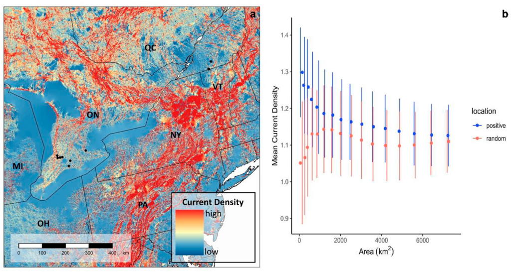
Fig. 5. (a) Locations of SARS-CoV2 positive white-tailed deer (Odocoileus virginianus) in Ontario (n = 7) and Quebec (n = 3), Canada plotted on the current density map. (b) Relationship between mean current density (±se) and area (km2). Mean current density was calculated within grid squares of increasing area centered on positive SARS-CoV2 cases and random locations within 20 km of positive cases. We expected that over large buffer areas, current density in positive and random cells would converge on background values, whereas current density should be higher in smaller cells if deer are selecting these areas for movement. Shapefile data obtained from Natural Earth. Projection: Lambert Conformal Conic, NAD83.
…
Discussion
Transboundary conservation can be a complex challenge that attempts to balance the needs of humans and biodiversity. We used naturalness methods to produce a high resolution, multispecies connectivity model that can be used to support transboundary conservation, land use, and natural heritage planning across the world’s longest land border between Canada and the United States. Natural barriers (e.g., mountains ranges, the Great Lakes, and the St. Lawrence River) and anthropogenic development along both sides of the border limit options for free movement of wildlife across the international boundary. In a time when biodiversity is increasingly threatened by human population spread and anthropogenic climate change, there is a critical need to identify opportunities for maintaining and enhancing transboundary connectivity. We expand on recent work by Pither et al. (2023), who used a naturalness approach to model connectivity across Canada at a resolution high enough (i.e., 300 m) to support national and regional land-use planning, and the Canadian portion of this map has been validated with 46 GPS-telemetry datasets (Brennan et al. 2025). Along with the predictive ability, computational, and financial benefits of naturalness connectivity models (Koen et al. 2014; Krosby et al. 2015; Pither et al. 2023; Brennan et al. 2025), they can reduce decision-making complexity by focussing conversations on general patterns of connectivity rather than specific-species needs (Parrott et al. 2019), thus making them ideal for guiding large-landscape conservation. Following the same cost surface parameterization and wall-to-wall methods as Pither et al. (2023), we produced a comparable connectivity model for the continental USA, which we used to produce a seamless current density map covering both countries.
Our model identified several areas of high current density that span the international boundary between Canada and the USA. Several of these areas are familiar as the subjects of existing international connectivity initiatives, such as the Y2Y (https://y2y.net/) and A2A regions (https://www.a2acollaborative.org/). Other locations are perhaps less well known, but appear to be important nonetheless, especially where high current density is caused by a pinch point due to proximity to barriers. For example, there are several corridors apparent around the Great Lakes, including the Arrowhead region west of Lake Superior, the Michigan UP, and the A2A region on the east side of Lake Ontario. Such corridors of high current density will be important to conserve to maintain wildlife connectivity across the international boundary. This requirement is underscored by the high degree of anthropogenic and industrial development in the Great Lakes, which contribute to movement barriers in the region. Without the maintenance of these movement corridors across the international boundary through the Great Lakes region (and elsewhere), we might expect Canada to have a deficit in biodiversity in the future compared to expectations arising from thermal changes associated with climate warming (Kerr and Packer 1998; Varrin et al. 2008). Species that are predicted to spread northwards from southern climates may be blocked by a lack of connectivity. As such, there is a need to identify potential movement corridors across the international boundary. We demonstrate how our high-resolution connectivity map can support transboundary connectivity conservation through its application to protected areas expansion, wildlife movement, and wildlife disease surveillance.
Transboundary protected areas
We examined how well current protected and conserved areas in the transborder region encompass hotspots for connectivity across the Canada–USA border. These hotspots often represent pinch points for connectivity where current flow is constrained by high-cost land cover features (Marrotte et al. 2017), thus making them critical for movement and more vulnerable to loss. Maintaining and enhancing these connectivity hotspots should therefore be priorities for transboundary conservation. We found that when we only considered protected areas with the highest levels of protection (IUCN Cat 1–4), less than a quarter of hotspots were included. Considering all categories of protected areas increased the coverage of connectivity hotspots to almost 50%, which highlights the importance of IUCN Cat 5 & 6+ sites (e.g., Other Effective area-based Conservations Measures) as effective tools for protecting areas important for connectivity. A similar increase in the proportion of protected areas when including IUCN Cat 5 & 6 sites was also noted by Thornton et al. (2020) along national borders throughout the Americas. Further, Hebblewhite et al. (2022) found that private land conservation accounted for a large proportion of protected areas expansion in the Y2Y region, particularly in the USA. While a number of protected areas in the Canada–USA border region are part of existing TBCAs (e.g., Waterton-Glacier International Peace Park; Lysenko et al. 2007) and so should have some degree of cooperation between them, Thornton et al. (2020) found that for Canadian and American protected areas, structural connectivity between protected areas was lower or comparable across borders than within. Our connectivity maps could be used to identify areas to further connect existing TBCAs. For example, the remaining 50% of connectivity hotspots not currently protected would expand protected areas and maintain connectivity.
Importantly, conservation of remaining connectivity hotspots will benefit from the contribution from private landowners, which could be carried out through a combination of land acquisitions, conservation easements, voluntary stewardship, and conservation incentives. Moreover, we found that Indigenous-managed lands, which have been found to contain significant habitat for biodiversity (Schuster et al. 2019), encompassed an additional 5% of transboundary connectivity hotspots. This coverage is on top of Indigenous-managed and -owned protected areas, which were included in our calculation of protected areas coverage. As such, any transboundary conservation efforts should occur in collaboration with these Indigenous communities/governments, uphold inherent Indigenous rights, and help advance Indigenous-led conservation. Further, while our map provides an important resource for identifying transboundary corridors at a regional and national scale, local connectivity modelling and land-use planning would be needed to identify where placement of new protected and conserved areas or sustainable management also makes sense for the communities in these areas.
Wildlife movement
We used independent wildlife data to demonstrate the ability of our connectivity model to predict areas important for transboundary wildlife movement. We found that elk movement between northern Montana and southern British Columbia and Alberta was positively related to current density, such that areas with higher probability of occurrence by elk were predicted by areas of higher current density. This area also coincides with the known Yellowstone to Yukon region, which is a critical movement corridor for many large mammals (Proctor et al. 2018; Hebblewhite et al. 2022). The conservation of large landscapes can be an effective strategy for protecting biodiversity by increasing the footprint of protected areas and connecting vast stretches of remaining intact habitats as has been demonstrated with the Yellowstone to Yukon Initiative. Such large-landscape conservation initiatives also have the ability to foster co-operation among multiple stakeholders across borders. The Y2Y initiative demonstrates a prime example of how large-landscape conservation and transboundary co-operation can have positive outcomes for wildlife movement, which can help guide conservation efforts across other transborder regions. For example, coordinated efforts by researchers, government, non-government organizations, and private industry to conserve critical connectivity areas helped to increase movement and gene flow of isolated grizzly bear populations across the Canada–USA border within the Y2Y region (Proctor et al. 2018). Along the eastern border region, limited colonization of suitable habitat by eastern wolf in the Adirondack to Laurentian (A2L) region has been attributed in part to a lack of connectivity as well as differences in habitat protection and hunting across the Canada and USA border (Cole et al. 2024). Long-term persistence of the eastern wolf would greatly benefit from improved transborder conservation as has been carried out within the Y2Y. Efforts, which we consider, could be supported by our high-resolution connectivity model.
Disease surveillance
Besides the many benefits of connectivity for biodiversity, negative consequences of connectivity can also arise, such as the transmission of pathogens among wild populations and potential spillover into humans. As such, disease surveillance efforts should benefit from considering how connectivity can influence spread of pathogens through wild populations, and in particular, across borders (Cullingham et al. 2009). To demonstrate the application of our connectivity model to transboundary disease surveillance, we explored the relationship between current density and positive detections of SARS-CoV-2 in wild white-tailed deer from Ontario and Quebec, Canada. While we only had a small number of sample locations (n = 10), we found a negative relationship between mean current density and area around positive locations, such that mean current density decreased with increasing area. In comparison, mean current density at random locations was generally uniform across the range of areas and was lower on average compared to positive locations. This suggests that SARS-CoV-2 positive deer were found in or adjacent to areas with a high probability of animal movement as predicted by our model. The close spatial proximity of SARS-CoV-2 positive wild deer to the Canada–USA border and evidence of divergence from American mink and humans across the border (Pickering et al. 2022; Kotwa et al. 2023) suggest that spillover is possible, and that landscape connectivity could aid transboundary viral transmission via host dispersal. Indeed, the relationship between landscape connectivity and disease spread is not a novel idea and similar findings have been noted by other studies. For instance, areas of high connectivity were found to be associated with high chronic wasting disease risk in elk (Nobert et al. 2016) and dispersion of the bacteria responsible for causing Lyme Disease (Borrelia burgdorferi) was found to be associated with landscape connectivity (Mechai et al. 2018). Taken together, these findings highlight the importance of incorporating connectivity modelling into disease surveillance strategies.
We note a barrier we encountered when searching for data to include in our case study was the difficulty in finding open access wildlife disease data, particularly that with high spatial resolution. This problem has also been noted by Stevens et al. (2024), who suggested that there is a need for data standards in the field of wildlife disease research and that research would greatly benefit from a central data repository for disease data as has been done for wildlife movement data (e.g., Movebank). We understand the sensitivity around providing accurate spatial locations of disease outbreaks, particularly on private or commercial properties; however, as new wildlife diseases continue to emerge with the ability to cause global pandemics (e.g., SARS-CoV-2), we think the benefits of open data should outweigh the risks. For example, the contemporary increase in wild mammals infected with highly pathenogenic avian influenza A (H5N1; Jakobek et al. 2023; Lair et al. 2024) and evidence of increased adaptation to mammalian hosts (Dholakia et al. 2025) pose a serious threat to humans (Plaza et al. 2024) and to wildlife populations already threatened by other human-mediated factors (e.g., habitat loss and climate change). Incorporation of connectivity modelling into disease surveillance efforts could inform targeted, risk-based approaches to assist with earlier detections, help inform best locations for vaccination programs, and identify areas with a high risk of spillover to human, other wildlife, or domestic animal populations.
…
Conclusion
We demonstrate the ability of our model to predict areas important for transboundary wildlife movement, support wildlife disease monitoring, and help identify priorities for future protection. As countries push to meet ambitious international conservation targets (e.g., 30 × 30 target of the KM-GBF), it will be critical not only to maintain and enhance connectivity within national boundaries, but also within the transborder region. Ensuring connected landscapes across national borders will undoubtedly have substantial benefits for biodiversity, especially in the face of climate change. Our current density map will be useful for supporting transboundary connectivity conservation between Canada and the USA, and our generalized, multispecies modelling approach can easily be applied to other countries to support their own transboundary connectivity initiatives.
Refer also to:
![]() In my view, the only way to save wild species on earth is for humans to massively depopulate. Quickly. But, the rich, rape religions and human ego and selfishness will never allow it.
In my view, the only way to save wild species on earth is for humans to massively depopulate. Quickly. But, the rich, rape religions and human ego and selfishness will never allow it.![]()