@frediotto.bsky.social:
One of the strongest, clearest increases in likelihood & intensity, attributable to climate change, I’ve seen in a complex index like fire weather – the more intense & frequent events in Greece & Türkiye are already outpacing efforts to adapt.
@race2extinct.bsky.social:
Killing aspen & birch for conifer profits is like slitting your own throat. B.C. forestry sprays glyphosate, feeds wildfires, destroys biodiversity, and burns its future along with the forest.
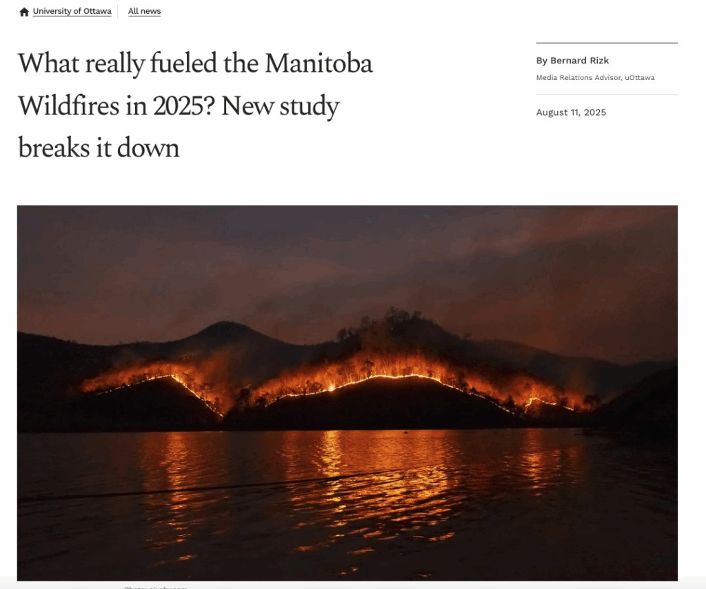
What really fueled the Manitoba Wildfires in 2025? New study breaks it down by Bernard Rizk, Media Relations Advisor, Aug 19, 2025, uOttawa News
A recent study is shedding light on the factors that contributed to the significant wildfires in Manitoba in May 2025. The research explores how unusual weather patterns and stressed vegetation combined to create an ideal environment for disaster.
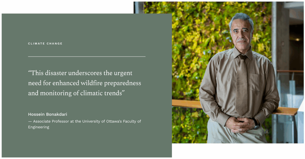
The research, published in the journal Earth and led by Hossein Bonakdari, Associate Professor at the University of Ottawa’s Faculty of Engineering, explores how anomalies in climate and vegetation indices preconditioned the landscape for these catastrophic fires.
In early May, extreme wildfires ravaged approximately 8,667 square kilometers of land, claiming lives and forcing the evacuation of nearly 1,000 residents. The study highlights that the wildfires were exacerbated by a combination of unseasonably warm temperatures, prolonged drought, and stressed vegetation.
“Our findings indicate that multiple environmental anomalies converged to create a highly flammable landscape,” Professor Bonakdari explains. “This disaster underscores the urgent need for enhanced wildfire preparedness and monitoring of climatic trends.”
Satellite data reveals hidden fire risk factors
The research used satellite data to track things like how much snow remained on the ground, how dry the soil was, and how green (or not) the landscape looked before the fires hit. The study found that significant rainfall deficits and reduced snowpack severely diminished soil moisture, leading to decreased vegetative greenness prior to ignition.
Soil moisture for early 2025 was among the driest in historical records, contributing to cumulative vegetation stress. The study emphasizes the importance of integrating climate and biosphere anomalies into wildfire risk monitoring, particularly in boreal regions vulnerable to climate change. “This demonstrates how moderate anomalies, occurring simultaneously, can elevate fire risk to levels that individual indicators might not highlight. This is called a synergistic interaction of climate anomalies — moderate but simultaneous stresses that together set the stage for extreme fires,” Professor Bonakdari adds.
The research highlighted the rapid spread of fire, contrasting with previous years and indicating a shift in fire dynamics due to climate stressors. It advocates using satellite-derived data to better understand fire risk and improve operational assessments.
The findings serve as a crucial reminder of the increasing vulnerability of boreal ecosystems to wildfire activity and the necessity for proactive measures in a changing climate.
Professor Bonakdari concludes, “As we face more frequent and severe fire seasons, it is imperative that we adapt our strategies to better anticipate and manage wildfire outbreaks.”
For more information about the study, please visit: A Lens on Fire Risk Drivers: The Role of Climate and Vegetation Index Anomalies in the May 2025 Manitoba Wildfires.
Ryan Katz-Rosene, PhD @ryankatzrosene:
One of my colleagues has just published a paper looking into the role climate change had in “landscape preconditioning” the massive Manitoba wildfires which we have been breathing in all summer: “These findings underscore the importance of integrating climate and biosphere anomalies into wildfire risk monitoring to enhance preparedness in boreal regions under accelerating climate change”
@pitbullmtkerr.bsky.social:
Climate change causing forests carrying capacity to decline.
Climate change is driving a silent, sinister change in Australia’s mountain ash forests
A Lens on Fire Risk Drivers: The Role of Climate and Vegetation Index Anomalies in the May 2025 Manitoba Wildfires by Afshin Amiri, Silvio Gumiere 1 and Hossein Bonakdari, Aug 1, 2025, Dept Soils and Agri-Food Engineering, Université Laval, Quebec
Earth2025, 6(3), 88; https://doi.org/10.3390/earth6030088
Submission received: 23 May 2025 / Revised: 17 July 2025 / Accepted: 28 July 2025 / Published: 1 August 2025
Abstract
In early May 2025, extreme wildfires swept across Manitoba, Canada, fueled by unseasonably warm temperatures, prolonged drought, and stressed vegetation. We explore how multi-source satellite indicators—such as anomalies in snow cover, precipitation, temperature, vegetation indices, and soil moisture in April–May—jointly signal landscape preconditioning for fire, highlighting the potential of these compound anomalies to inform fire risk awareness in boreal regions. Results indicate that rainfall deficits and diminished snowpack significantly reduced soil moisture, which subsequently decreased vegetative greenness and created a flammable environment prior to ignition. This concept captures how multiple moderate anomalies, when occurring simultaneously, can converge to create high-impact fire conditions that would not be flagged by individual thresholds alone. These findings underscore the importance of integrating climate and biosphere anomalies into wildfire risk monitoring to enhance preparedness in boreal regions under accelerating climate change.
1. Introduction
In early May 2025, severe wildfires broke out in various parts of Manitoba, Canada, and spread rapidly. By the end of May 2025, three of the most intense fires had collectively burned approximately 8667 square kilometers of land and forest (Figure 1). This wildfire caused the deaths of two people and led to the evacuation of approximately 1000 residents from Lac du Bonnet and surrounding areas [1]. These fires emerged under conditions of ongoing drought and unseasonably warm weather, contributing to the rapid spread of fires and extensive damage to the landscape. The disaster occurred amid an exceptional heat wave in Manitoba, with temperatures in Winnipeg reaching 37 °C (99 °F) — the highest recorded in 125 years [2]. A national map, based on data from the Canadian Drought Monitor, illustrates drought intensity across Canada at the end of April 2025, with parts of Manitoba marked as abnormally dry (D0) and under moderate drought (D1) conditions (Figure 1a). This event highlights the importance of enhanced wildfire preparedness and more comprehensive monitoring of drought trends across Canada, particularly in provinces such as Manitoba, where the combination of extensive boreal forests, increasing fire weather, and remote communities increases wildfire vulnerability.

Figure 1. (a) Drought intensity across Canada showing areas ranging from abnormally dry (D0) to moderate drought (D1) as of the end of April 2025. Data were extracted from the Canadian Drought Monitor. (https://open.canada.ca/data/en/dataset/292646cd-619f-4200-afb1-8b2c52f984a2. accessed on 10 May 2025). (b) Manitoba burned areas were extracted from Landsat 8 and Sentinel-2 satellite images. The boundaries of the wildfires from May 2025 are marked in black, with the area of each wildfire labeled on the map. (c) Landsat 8 imagery from 4 May 2025 shows the initial fire ignition site with an early burned area delineated using Sentinel-2 imagery on 10 May 2025. (d) A significant wildfire expansion is evident in central-eastern Manitoba, as revealed by Sentinel-2 imagery from 14 May 2025. (e) Fire event in southeastern Manitoba with a smaller burned area, also mapped from Sentinel-2 data acquired on 14 May 2025. Yellow polygons indicate fire perimeters. The imagery uses a false-color composite with shortwave infrared 2 (SWIR-2), near-infrared (NIR), and blue bands.
Severe wildfires erupted in various locations across Manitoba in May 2025, showing rapid progression over a short period (Figure 1b). A Landsat 8 image acquired on 4 May 2025 shows the burned area one day after ignition, with initial fire scars and smoke clearly visible (Figure 1c, left). By 10 May, Sentinel-2 imagery reveals that the fire had expanded dramatically to cover 381.5 km2, indicating rapid spread over less than a week (Figure 1c, right). Further east, a fire that started on 12 May had already grown to 952.7 km2 by 14 May, with a clear smoke plume along its southern boundary indicating ongoing fire activity and wind-driven transport (Figure 1d). Another fire that began on 10 May in southeastern Manitoba reached 64.8 km2 by 14 May, exhibiting a compact burn pattern within a forest–agriculture interface (Figure 1e). The rate of fire spread during these events was notably rapid compared to typical recent fire seasons in Manitoba. For instance, wildfires in Manitoba burned approximately 7898 km2 in 2013 and 9525 km2 in 2021. However, it took several weeks for the fires to reach such extents. In contrast, the 2025 fires expanded rapidly within the first weeks of May, highlighting an unusual early-season behavior that may reflect changing fire dynamics under compound climate stressors.
Advancements in remote sensing technologies have greatly enhanced our ability to monitor and detect wildfires [3]. Optical satellite imageries, such as Landsat and Sentinel-2, allow for precise delineation of wildfire boundaries and the extent of their spread [4]. For instance, by applying the Needleleaf Index [5] to satellite imagery, we estimate that approximately 3206 km2 of needleleaf forest burned in Manitoba by the end of May 2025, demonstrating how such vegetation metrics can support post-fire impact assessment. Analysis of the Moderate Resolution Imaging Spectroradiometer (MODIS) land cover product (MCD12Q1) indicates that approximately 7033 km2 burned within sparsely to moderately forested regions (10–60% canopy cover), with an additional 287.9 km2 affecting agricultural lands. These distributions suggest that many fires were concentrated in forest–agriculture transition zones, where fire susceptibility is often underestimated in early spring. Furthermore, remote sensing provides valuable insights into the underlying causes, dynamics, and characteristics that drive wildfire intensification, enabling more effective fire management and mitigation strategies. Understanding how these environmental factors interact with wildfire dynamics is crucial, particularly in the context of a changing climate and altered land surface conditions that are reshaping fire regimes in boreal ecosystems [6,7]. Recent shifts in climatic parameters and land surface conditions have significantly altered fire regimes in boreal ecosystems [8]. This study aims to provide a focused analysis of the early-spring 2025 wildfire outbreak in Manitoba by examining the combined influence of multiple environmental anomalies that occurred in April, including snow cover depletion, precipitation deficits, soil moisture reduction, temperature shifts, and vegetation stress. We analyzed anomalies in six environmental variables: January–May 2025 soil moisture anomaly (ERA5-Land), April values of air temperature and precipitation (ERA5-Land), snow cover extent (MODIS), leaf area index (MODIS LAI), and vegetation greenness (MODIS NDVI), covering the period of 2003–2025. All variables were standardized using Z-scores to allow for intercomparison. We used linear regression to identify trends, Pearson correlation to examine inter-variable relationships, and multiple linear regression to assess the combined effects of anomalies on burned area. Spatial overlap between environmental stress patterns and fire activity was also evaluated. Unlike many prior studies that focus on peak summer fire seasons, our work highlights how moderate but temporally coincident anomalies outside the traditional fire window can precondition landscapes for severe wildfire outbreaks. By integrating satellite-derived datasets, we seek to improve understanding of early-season fire risk dynamics in boreal ecosystems.
…
3. Conclusions
The May 2025 wildfires in Manitoba resulted from multiple interacting environmental stressors, including reduced April precipitation, early snowmelt, soil moisture deficits, vegetation stress, and declining greenness, all of which contributed to a highly flammable landscape. While each anomaly alone appeared moderate, the observed spatial and temporal overlap of moderate anomalies suggests a potential synergistic effect that significantly preconditioned the environment for ignition. This effect was particularly pronounced in forest–agriculture transition zones, where fire susceptibility is often underestimated in early spring. By quantifying these relationships using multi-source satellite and reanalysis datasets, this study provides new empirical support for the role of compound biosphere–climate anomalies as early warning signals. These findings underscore the crucial need to incorporate satellite-derived environmental indicators into operational fire risk assessments, enabling better anticipation and management of spring wildfire outbreaks in boreal ecosystems. This is particularly important in a changing climate, where such compound conditions are expected to become more frequent, subtle, and hazardous.
North America’s forests used to burn a lot more than present… So, is climate change really making wildfires worse today? by Ryan Katz-Rosene, Aug 20, 2025, The Trade Off
[This is Part 1 of a two-part post… make sure to check out Part 2]
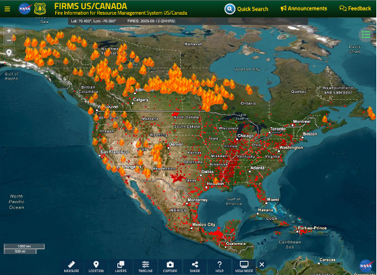
Screenshot from the Fire Information for Resource Management System – August 13, 2025.
Research into burn rates across North America before 1900 shows that before then, many parts of the continent burned more so than present. The declarative title of a recent article by Sean Parks et al. confirms this: “A fire deficit persists across diverse North American forests despite recent increases in area burned”. Similarly, recent research into Canada’s historical boreal wildfire regime suggests that contemporary burn rates in some areas of the boreal tend to fall within the historical boundaries of natural variability going back to 1800 (with some notable exceptions).
Many who follow news about climate change will find this surprising: Aren’t burn areas across North America generally increasing throughout the continent due to global warming? How are we to make sense of this apparent contradiction between high rates of historical burn rates across North America prior to the 20th Century, when the climate was cooler than present, and the current trend of increasing wildfire burn area, as the climate warms?
What explains this see-saw, and how does climate change factor into it – if at all? To help contextualize what’s going on, I read the literature and reached out to several experts in this area. Here’s what I found out…
Yes, average burn area has increased in recent decades
First, contemporary burn rates going back over roughly the last half Century or so are indeed on an increasing trend. This chart with data from Canada’s Interagency Forest Fire Centre (below) shows that the total area burned across Canada trended up from 1983 to 2024, despite a considerable amount of year-to-year variability. The figure also hints at a remarkable countervailing trend of declining numbers of fires across Canada over this same period, suggesting that the average fire size has increased substantially.
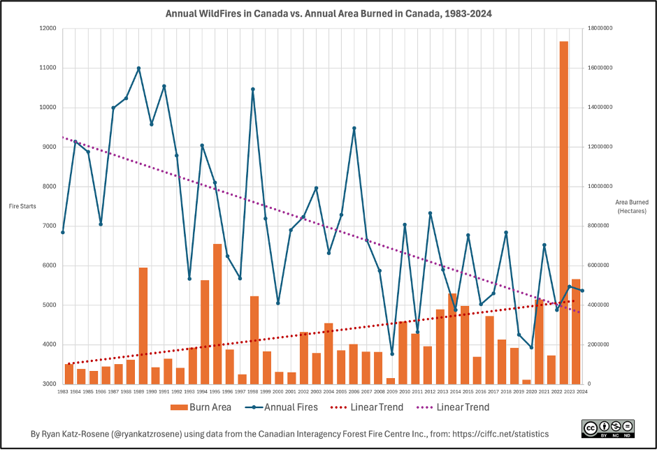
Figure produced by author.
As a paper by Hanes et al. explains, while human-caused fires have declined in frequency and are responsible for a much smaller proportion of the total area burned, lightning-caused fires now dominate burn area in Canada. These lightning-caused fires account for around 85% of large fires (fires greater than 200 hectares), and approximately 91% of the area burned leading up to 2015 (when the study was published). This is one clue that our changing climate is potentially changing the nature of wildfires in Canada: Less fires overall; greater average size of fires, on average; more area burned, on average.
A relatively similar pattern is seen in the United States: Since the 1980s, the number of wildfires has generally trended down (if not held relatively steady), while the average burn area has increased. So, yes, the trend over the last half Century or so has been one of larger fires and increasing burn area, in both Canada and the US. This period corresponds with the ‘Great Acceleration’ in global warming seen in the Post-War Years, particularly as of the 1970s (with Earth’s climate warming more than 1°C over this period).
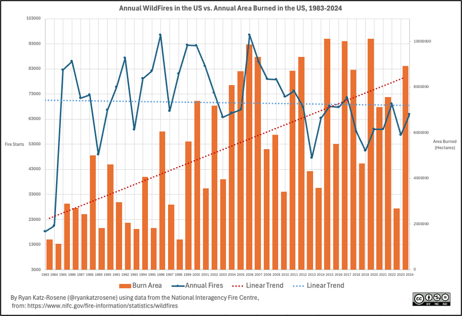
Figure produced by author.
Global warming is a key driver
As discussed below, changes to the climate are not the only driver shaping wildfire activity in North America. However, in recent decades, it has been a key factor driving the trends discussed above. There are a few mechanisms through which global warming can contribute to increased wildfire burn area. For one, hotter and drier conditions can result in extreme fire weather, and it can extend the overall length of the wildfire season. Further, elevated temperatures increase evaporative demand (known as the “atmospheric thirst”), leading to drier fuels that are more likely to ignite and burn with greater intensity.
As Mike Flannigan – one of Canada’s leading experts in boreal wildfire dynamics – explained to me, there are three main ingredients in the “recipe for wildfire” – Fuel, Ignition, and Weather – and changes to our climate are influencing all of these in complex ways: First, as noted above, warmer temperatures are having a substantial effect in terms of drying fuels, particularly dead vegetation that responds quickly to weather conditions (such as leaves, grasses, and needles).. Because a warmer atmosphere increases evaporative demand, it can rapidly pull moisture from this class of vegetation, leading to more readily ignitable fuels.
While it is true that a warmer atmosphere can hold more water vapour (about 7% more per degree Celsius of warming), thereby also increasing the potential for heavier rainfall events; and while it is also true that total precipitation has increased overall in North America over the last Century (notably in northern and eastern regions, while the Southern and Western portions of the continent have generally seen a decrease), wildfire researcher Sean Parks explained to me that that even if precipitation has increased in some regions due to climate change, it has not offset the effect of increased evaporative demand caused by rising temperatures during the summer seasons: “It would take a lot more precipitation to offset the effects of increased evaporative demand on fuel moisture.” In fact, prior research by Flannigan and colleagues has shown that for every degree of warming, precipitation has to increase by between 5% and 15% (depending on the fuel type) to compensate for the drying caused by warmer temperatures.
Second, the number of ignitions tells an interesting story. In Canada, these have clearly been on a downward trend, mostly because of greater public awareness and other preventative measures. And in the US, aside from relatively low numbers of fire starts in the early 80s, the total number of fires appears to also be declining since the mid-80s.
It is not clear whether the total number of lightning-caused fires is increasing, or whether those fires themselves are just becoming larger. One study projected lightning strikes to increase by 12% across the continental US for every degree Celsius of global warming, and about 50% over this Century; However, another study focusing at lightning in Canada, showed a general decline in documented lightning strikes over the last quarter Century, most pronounced in Ontario and Quebec and adjacent US states. One paper by Jain et al. regarding the exceptional 2023 wildfire season in Canda suggests that there may be improved “lightning-ignition efficiency” – wherein the existence of drier fuels makes it easier for lightning to start a remote fire, even in the case of a lower total number of lightning strikes (as was the case in 2023).
Third, the weather itself is getting warmer, with annual surface temperatures across North America having increased by about 1.5°C relative to the second half of the 20th Century mean. The figure below shows the change in average surface temperature of our “current climate” (the average annual value over the last 15 years) from the climate of half a Century ago (the average annual value over the 15 years from 1970 to 1984). Almost every part of North America has gotten warmer over this period, by one or two degrees, on average. Warming is more pronounced further north.
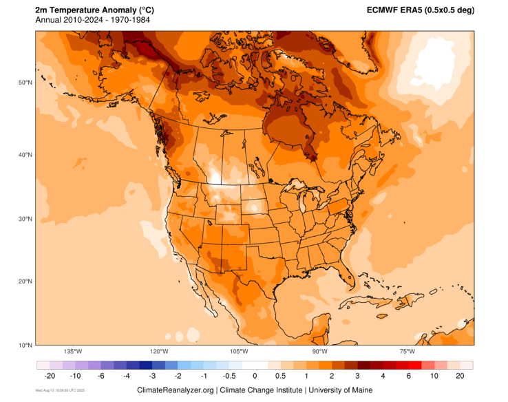
Figure generated at https://climatereanalyzer.org/research_tools/monthly_maps/
And so it is that – in North America at least – modern global warming has generally contributed to more extensive and more severe wildfires, thanks in large part to drier fuels, a longer wildfire season, and declining winter snowpacks. However, humans have also influenced those wildfire ingredients in other ways, and this gets us to the question of historical wildfire burn rates…
Yes, North American forests used to burn more so than present
The experts that I spoke to suggested that many North American forested areas used to burn more so than present – ‘present’ in this instance meaning the annual average of the decade preceding 2023. Tree ring-based research (or “dendrochronology”) generally confirms this, with some exceptions. For instance, a paper by Victor Danneyrolles and colleagues found that in four key zones analyzed within Canada, three showed a relative decline in the mean annual burn rates of recent decades relative to the early 19th Century (see Figure below). One key exception was Wood Buffalo National Park, whose burn rate over the 2014-2023 period (denoted in red dot with crosshairs) was higher than the historical range of natural variability.
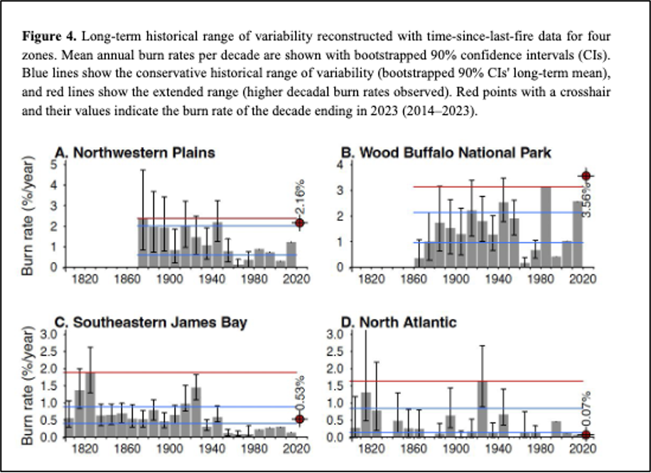
Figure 4 from Danneyrolles et al., 2024: https://cdnsciencepub.com/doi/epdf/10.1139/cjfr-2024-0216
Similarly, the conceptual figure below from Parks et al. shows how even though average annual burn rates (in a prototypical U.S. forest) may be seeing increases over the last half-Century, such rates nevertheless remain at levels that are significantly below the 17th through 19th Century baselines.

Figure 4 from Parks et al., 2025: https://www.nature.com/articles/s41467-025-56333-8
As the conceptual figure implies, fire exclusion and suppression efforts emerging sometime in the late 1800s in the United States coincided with a drop in annual burn area. As Sean Parks explained to me, this involved a whole range of actions aside from merely actively putting out fires (or “active suppression”).
Fire exclusion was also linked to colonial expansion and settlement across the continent, in a few ways: Many Indigenous nations used fire widely (for a host of reasons – to clear land, to support hunting and agriculture, for cultural reasons, and for land management, etc.), and these practices were forcibly removed or deemed illegal during the period of colonial expansion, which substantially reduced a source of more frequent (often low-intensity fires). Similarly, many forests were cut or thinned for agricultural expansion or for the lumber industry, and this also reduced wildfire likelihood, and its ability to spread. In some cases, Flannigan noted, there was an initial increase in fire during the early colonial expansion phase, as forests were sometimes cleared and the burning of debris would sometimes cause wildfires.
Then, with the expansion of roads into remote areas, the invention of the airplane, improvements in water pumping and management systems, and better monitoring – alongside a changing philosophy in the late 19th and early 20th Centuries which asserted that wildfires should be eliminated, fire suppression efforts became much more extensive, and more effective. Here I should note that Ellen Whitman, a forest fire research scientist at the Canadian Forest Service, told me these types of exclusion and suppression practices were less extensive in the Canadian boreal as they were in US forests; and typically occurred later in Canada than they did in the US. Yet they were nevertheless still present.

“Civilian Conservation Corps fire fighting crew, Clark National Forest, 1937.” From: https://foresthistory.org/research-explore/us-forest-service-history/policy-and-law/fire-u-s-forest-service/u-s-forest-service-fire-suppression/
The flip-side of improvements in fire suppression is that in some areas, fuels (vegetation) were able to accumulate over time. In turn, these greater fuel loads have meant that some recent fires have been more intense than perhaps they would have been in the absence of suppression efforts. Parks et al. thus conclude that even though contemporary wildfire burn rates may fall within historical ranges, the contemporary fire severity is much greater, causing greater ecological and societal harm than the “low-to-moderate-severity” “surface fires” that characterized the pre-Industrial era. While that in itself may be more a result of changes in human forest management practices than from climate change, Parks notes that global warming has been an important compounding factor in making today’s wildfires more severe, due to the increased heat and evaporative demand (as discussed above).
While Parks et al.’s schematic shows a clear framework for understanding the contemporary fire deficit within the U.S. (and corresponding shifts in the severity of today’s fires), the boreal experts I spoke with (including co-authors of the Parks et al. study) noted that the situation North of the 49th Parallel is diverse and complex, and that there is considerable regional differentiation. That is, the fire deficit is more representative of U.S. forests than the boreal. Whitman noted to me that “there is much less data” about whether contemporary burn rates in the boreal are at a deficit compared to the pre-Industrial era. Similarly, she noted that the 2023 fire season was so extensive (burning 4% of Canada’s forest area) that it would be “very surprising if this kind of thing happened often in the past.” That is – if it did – one would expect Canada not to have remained a largely forested country! As Flannigan added (referring to pan-Canadian burn areas in 2023, 2024 and thus far in 2025 combined): No three year period in our modern record has seen more than 5 million hectares burned in each year.
[This is the end of Part 1… please check out Part 2 when it comes out tomorrow!]
![]() Refer also to:
Refer also to:
![]() And then there’s frac’ing intentionally removing vast quantities of surface water from the hydrogeological cycle – permanently!
And then there’s frac’ing intentionally removing vast quantities of surface water from the hydrogeological cycle – permanently!![]()
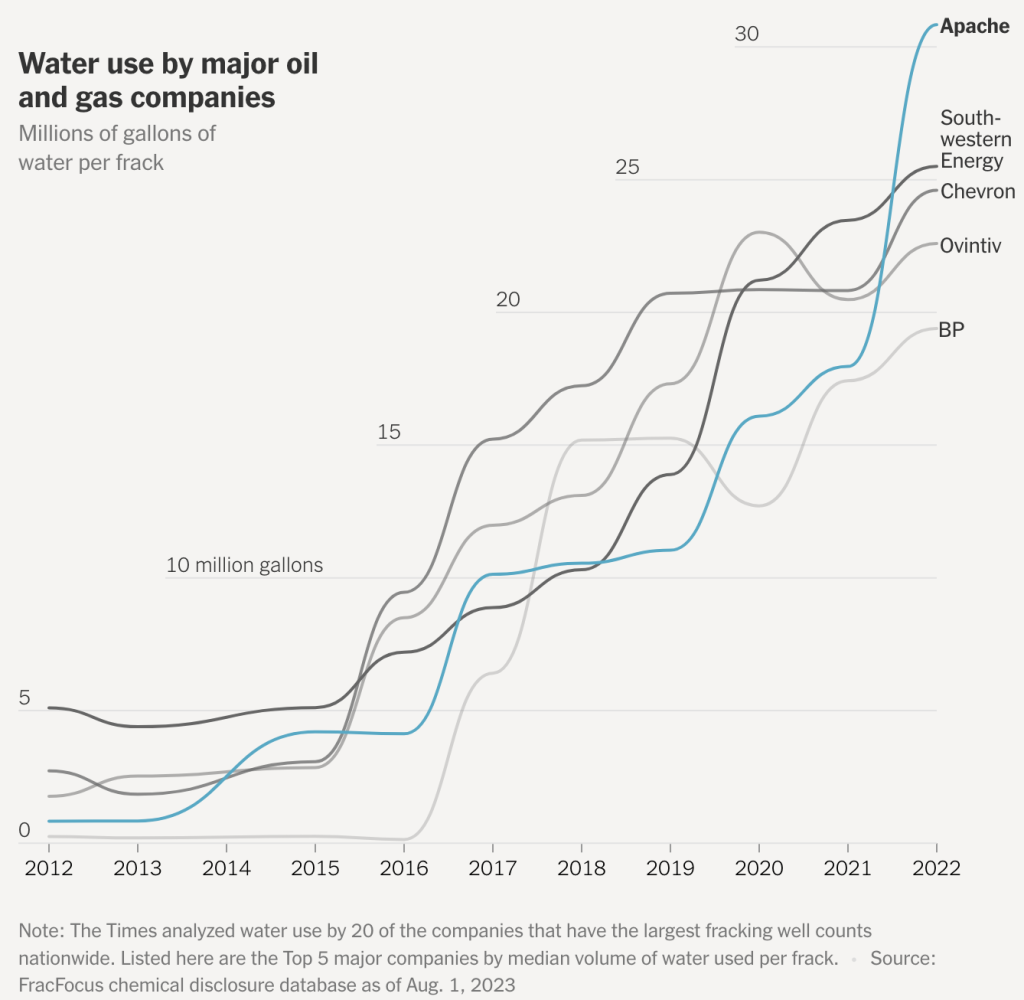
2023: Monster Fracs, getting bigger and thirstier, threatening America’s drinking water aquifers
This is the most important concern about water injected for frac’ing that is rarely reported in main media:
A proportion (25% to 100%) of the water used in hydraulic fracturing is not recovered, and consequently this water is lost permanently to re-use, which differs from some other water uses in which water can be recovered and processed for re-use.
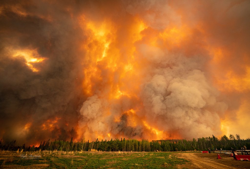
2023 05 14: Fox Creek Alberta, Frac Central, Wall of Wildfire and Smoke, nearly burned down the town. Photo by Kyle Britain.