Province fires back on Blueberry River FN’s cumulative effects claims, First Nation says province not doing enough to prevent resource development from impacting Treaty 8 rights by Mike Carter, July 4, 2016, Dawson Creek Mirror
Minister of Aboriginal Relations and Reconcilliation John Rustad is firing back after the Blueberry River First Nations’ (BRFN) called out the provincial government last week for not doing enough to protect land use rights under Treaty 8.
BRFN released the 2016 Disturbance Atlas report to the public June 28, detailing how resource development on the land has impacted the nation’s ability to continue traditional practices such as hunting, fishing, trapping and gathering medicinal plants. The nation filed a 2015 law suit in the BC Supreme Court along the same lines.
In a statement emailed to the Dawson Creek Mirror the same day as the release of the report, Rustad said the government is renewing its attempts to involve BRFN in its ongoing cumulative assessment projects. [Now? Decades too late! Refer below to some of the data compiled by the BRFN in their new report.]
“Several attempts have been made to get Blueberry River First Nations involved in Northeast cumulative effects (management) programs,” Rustad wrote. [Synergy Waste the People’s Time Heart & Energy Propaganda Programs?]
The government announced a cumulative effects framework in May. [Intentional Insult or “reaction” because of being sued? Refer to the visuals below to see just how insulting it is for the BC government to start now]
“The framework provides policy, procedures and tools to improve the consideration of cumulative effects in natural resource decision making,” Rustad said. [What kind of fraudulent word baloney is this? “To improve consideration of” does not mean “doing” cumulative effects assessments!]
Rustad also pointed to the province’s liquefied natural gas environmental stewardship initiative which includes the Regional Strategic Environmental Assessment (RESA) agreement — a partnership between the Doig River, Halfway River, Prophet River, Saulteau and West Moberly First Nations.
The government said a RESA project team made up of members from these First Nations, the province and natural gas industry proponents met Nov. 30 to begin planning this work. The next steps include submitting a budget and work plan for review. [Again, decades too late, and feel good, join the circle, sing-a-long stewardship propaganda with the expected associated bribery is not assessing cumulative effects]
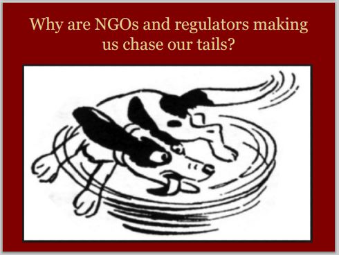
“We recognize the importance of assessing, monitoring and managing the cumulative effects of resource development,” Rustad said. “We are renewing our attempts to have BRFN join our regional initiatives.” [NEITHER STATEMENT MEANS “DOING” CUMULATIVE EFFECTS ASSESSMENTS. “Recognizing the importance” of such assessments and mitigating the expected effects before they happen was determined having high value decades ago in Canada, but, no government, company or regulator is doing more than lie, synergize and talk a lot. Action on cumulative effects is sorely missing in Canada, notably where oil and gas operates. Why would BRFN (or any FN more interested in actual mitigation of cumulative effects rather than take bribes) join govt/industry synergy initiatives that are nothing more than time and energy wasting, tail chasing, propaganda round tables that go on for years, madly going nowhere but put industry and regulator responsibilities onto the shoulders of FN and all other communities and families harmed by oil and gas developments?

Slides from Ernst presentations
BRFN Chief Marvin Yahey said that the province’s initiatives thus far have not done the job.
“Despite raising these concerns directly with the premier and with provincial ministers, there has been no meaningful response to this critical threat,” Yahey said. “Instead, the province continues to approve major industrial undertakings in our territory, including major fracking operations and the Site C dam, willfully ignoring that each new approval brings our unique culture closer to extinction.”
As a result, the nation began its own study of the cumulative impacts called the Land Stewardship Framework. BRFN said it will offer a “science-based solution” to the issues it outlines, and a pathway to “sustainable development” in the area. [Is such a thing possible with the current levels of harm by fracing unconventional oil and gas development? Emphasis added]
INTERLUDE:
Petronas decision is a watershed moment by Caitlyn Vernon, July 3, 2016, Vancouver Sun
John Rustad, B.C.’s minister of aboriginal relations and reconciliation, recently belittled all opposition to the Petronas Pacific Northwest LNG proposal at the mouth of the Skeena River as “professional protesters”.
Was he referring to 135 Canadian and international fish experts and aquatic scientists who have called on the federal government to reject the project because of the risks it poses to a billion juvenile salmon and Canada’s second-largest salmon run?
Perhaps the minister had the Canadian Environmental Assessment Agency itself in mind? The agency has described the liquefied fracked gas project’s greenhouse gas emissions as “high in magnitude, continuous, irreversible and global in extent.”
Or maybe he was referring to the 11,000 British Columbians who, in the space of nine short days, emailed Prime Minister Justin Trudeau, imploring him to reject the project as a threat to salmon, our climate and our economy?
If built, the Petronas plant would be one of the largest greenhouse gas emitters in all of Canada, releasing the equivalent of 5.3 billion tonnes of carbon dioxide over 20 years, from fracking, transporting, liquefying and burning methane.
Studies have shown that the emissions from extracting and burning fracked gas, whether here or in Asia, are as bad or worse than those from coal.
The Petronas plant alone would make it impossible for B.C. to meet its greenhouse gas reduction targets for 2050. It would also undermine Canada’s international climate change commitments, and continue the destabilization of the very climate on which our continued health, security and prosperity depend.
As Premier Christy Clark recently pointed out, climate change is the underlying cause behind this spring’s heat wave, wildfires and home evacuations. Yet the province’s LNG agenda will only add fuel to the fire.
Albert Einstein famously described insanity as doing the same thing over and over again and expecting a different result. [SYNERGY AND GOVT/INDUSTRY ROUND TABLES!] That is our provincial government’s approach — the insanity of talking climate leadership while continuing to promote an outdated fossil fuel economy.
To defend our communities and our children from the harsh droughts, wildfires and food insecurity predicted by climate scientists, we need leadership that supports and grows the clean energy solutions that are known and already being successfully implemented in other jurisdictions around the world.
As LNG prices continue to tumble, there is more and more evidence that we can transition away from fossil fuels in as little as 10 years: solar and wind are outperforming fossil fuels in the energy market, and clean green energy and technology create seven to eight times as many jobs as fossil fuels for the same investment. Not only can we dare to dream of a future with a livable climate, prosperous economy, and good meaningful jobs for all — we can make it reality.
Trudeau is facing his watershed moment: whether or not to approve the Petronas proposal. It is his first big climate test. If he is truly committed to limiting global warming to 1.5 to 2 degrees he cannot approve this project. It’s that simple.
Will Trudeau stand with science, defend our salmon, and reject the Petronas proposal? Or will he trample over serious First Nations objections and opposition, and send liquefied fracked gas tankers through the Great Bear Rainforest?
Trudeau’s government was elected on promises to defend our environment and take action on climate. The stakes are too high to waver at this crucial time in our history.
It’s time to say no to Petronas, and yes to wild salmon, healthy rivers and marine ecosystems. It’s time to say no to increased wildfires and drought, and yes to green jobs and a livable climate for all Canadians and future generations.
Characterizing genuine concern about our future by scientists and everyday British Columbians as “professional protest,” as Rustad has done, perpetuates a divisive politics that hinders effective climate action. Our climate doesn’t distinguish between “us” and “them.”
We are in this boat together; if we don’t come together to tackle this crisis, we will all be caught up in the whirlwind. [Emphasis added]
B.C. not doing enough to uphold treaty rights: Blueberry River FN, More than three quarters of traditional territory impact by industry, nation says by Mike Carter, June 28, 2016, Dawson Creek Mirror
Blueberry River First Nations (BRFN) officials say the B.C. government is not doing enough to slow industrial impacts on its land, the effects of which it says are wreaking havoc on treaty rights.
In a study released June 28, the nation says the province has continued to greenlight development on its territory at “an accelerated scale and rate, despite its knowledge of the worsening cumulative effects.”
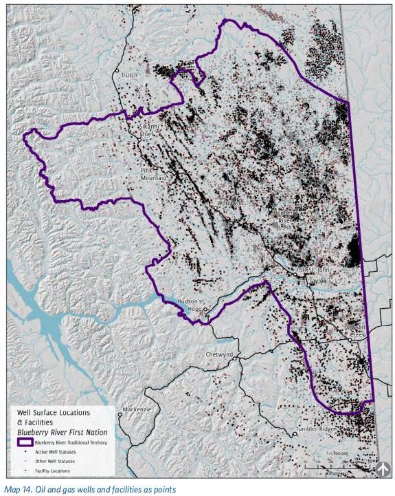
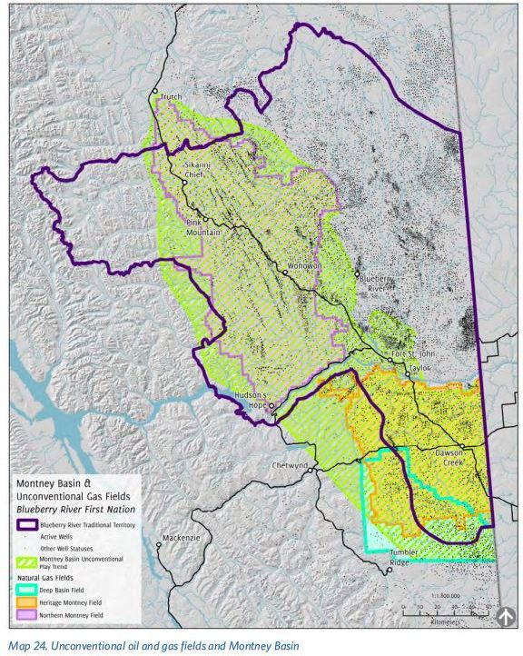
BRFN’s reserve is located north of Fort St. John, but its traditional territory stretches from south of Dawson Creek, west beyond the Pink Mountain area and north past Sikanni Chief, ending just south of the Klua Lakes protected area.
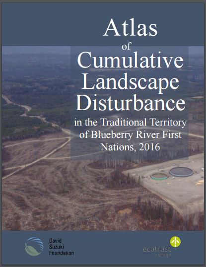
The 2016 Disturbance Atlas follows on the heels of a similar 2012 study. Work on the Atlas was carried out in cooperation with the David Suzuki Foundation and Ecotrust Canada.
The Atlas shows 84 per cent of the First Nations’ traditional land has been impacted in some way by logging, oil and gas or hydroelectric projects, including the Site C dam.
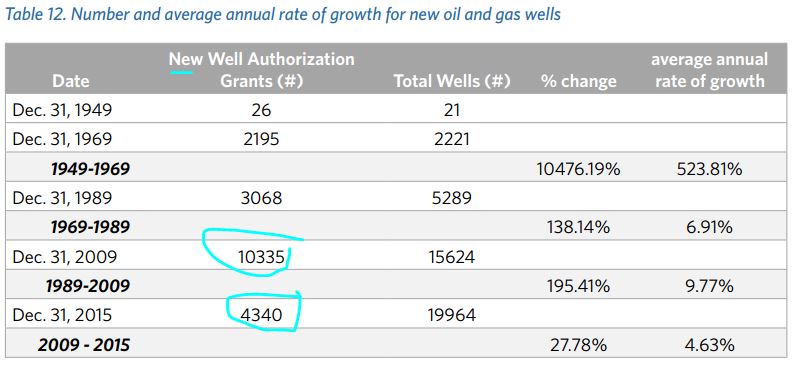
Since 2012, the government has given the go-ahead to more than 2,600 oil and gas wells, 2,624 km of access and development roads, 1,500 km of new pipelines and 9,400 km of seismic lines in BRFN’s traditional territory.
“The findings of the 2016 report clearly show that even though the provincial government has clear notice of the scale of harm… it has worked to make the problem worse, not better,” Chief Marvin Yahey said in a news conference.
“Fracking, forestry, roads and other development is pushing us further and further to the edges of our territory and we are no longer able to practice our treaty rights in the places we’ve always known.”
Concerns regarding cumulative impacts were the basis of a 2015 lawsuit over the breach of the guarantees to traditional land use contained in Treaty 8.
Industrial development, particularly in the oil and gas industry, has increased sharply over the past few decades.
“Despite raising these concerns directly with the premier and with provincial ministers, there has been no meaningful response to this critical threat,” Yahey said. “Instead, the province continues to approve major industrial undertakings in our territory, including major fracking operations and the Site C dam, willfully ignoring that each new approval brings our unique culture closer to extinction.”
The study outlines critical areas of the land in need of attention, including protections for some of the most important zones for hunting, trapping, and gathering food and medicinal plants.
BRFN also said requests have been made directly to Premier Christy Clark for a cumulative impacts study of its territory, but “B.C. has not responded.”
As a result, the nation began its own study of the cumulative impacts called the Land Stewardship Framework. BRFN said it will offer a “science-based solution” to the issues it outlines, and a pathway to sustainable development in the area.
“(We) want to ensure that generations to come are able to meaningfully exercise their treaty rights to live off the land,” a BRFN release said. “The ability of (our) children to hunt, eat moose, harvest berries and medicinal plants and learn their language while on the land hangs in the balance.”
In a statement emailed to the Mirror, Raustad said the goverment is aware of BRFN’s concerns regarding resource development within its territory.
“We have developed a cumulative effects framework that is being applied in Northeast B.C.,” Raustad wrote. “We are committed to reaching [slick escape hatch words] a respectful, government-to-government relationship that ensures BRFN has both economic opportunities and a strong role in environmental stewardship.” [Emphasis added]
Atlas of Cumulative Landscape Disturbance in the Traditional Territory of Blueberry River First Nations, 2016 by Eliana Macdonald, June 2016, Ecotrust Canada ISBN: 978-1-988424-00-2 Electronic book only
…
25 Oil and Gas Well Surface locations for British Columbia: https://www.bcogc.ca/public-zone/gis-data
…
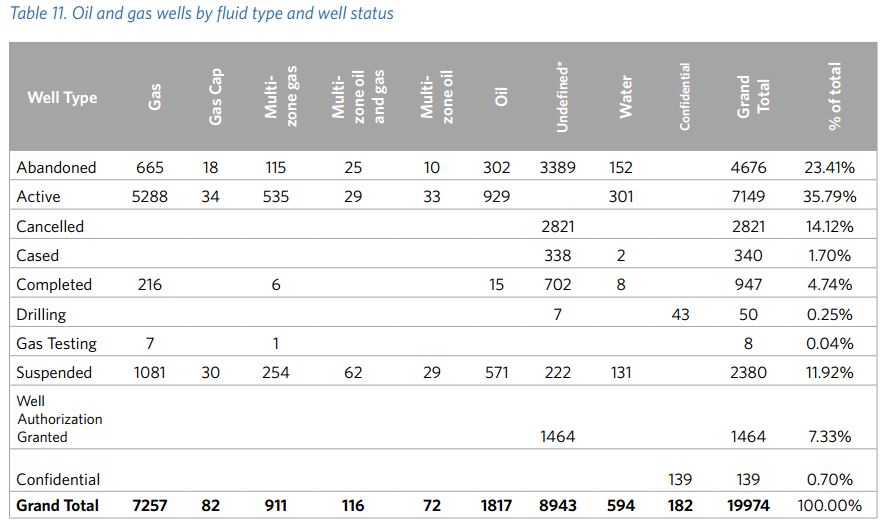
* “Undefined” fluid types are wells that have completed the first stage, but have not completed the second. When the type of fluid has been determined, this status is updated by the Oil and Gas Commission (unless they are abandoned or cancelled prior to the fluid type determination).
…
…
 ...
...
…
…
Water withdrawals and stream crossings
The BC Oil and Gas Commission can authorize access to surface water for oil and gas activities, under Section 845 of the Water Act.46 These water use approvals last for up to one year, and are nontransferrable.
Streams and rivers are the source of the largest volume of water withdrawn (64%) in Blueberry River First Nations traditional territory from 2006 to 2015. The highest number of water withdrawals47 in the First Nation’s traditional territory is from water source dugouts, which account for 59% of all withdrawal points. They are defined as a borrow pit that has accumulated water, such as from snowmelt, rainfall or groundwater inflow.48
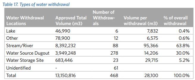
Section 9 of the Water Act regulates “changes in or about a stream.” Section 949 crossing points are shown where the Commission has approved points of crossing over streams. These points must be applied for by an oil and gas operator in relation to their own oil and gas operations and are approved under the delegated authorities by the Water Act. The total number of points under Section 9 of the Water Act in Blueberry River First Nations traditional territory is 1,076.
45 The Water Sustainability Act SBC 2015 c. 14 took effect February 29, 2016 and replaced the Water Act. What was Section 8 in Water Act is now Section 10 in the Water Sustainability Act and what was Section 9 is now Section 11.
46 BC Oil and Gas Commission Fact Sheet: https://www.bcogc.ca/node/11474/download
47 OGC Section 8 Point Locations (Public Version): http://catalogue.data.gov.bc.ca/dataset/ogc-section-8- point-locations-public-version (also available at the OGC website)
48 http://fracfocus.ca/hydraulic-fracturing-how-it-works/casing/borrow-pits-water-storage-sites
49 OGC Section 9 Point Locations (Public Version): http://catalogue.data.gov.bc.ca/dataset/ogc-section- 9-point-locations-public-version (also available at the OGC website).
…
Cumulative Effects
The Canadian Environmental Assessment Agency defines cumulative effects as “changes to the environment that are caused by an action in combination with other past, present and future human actions.”64
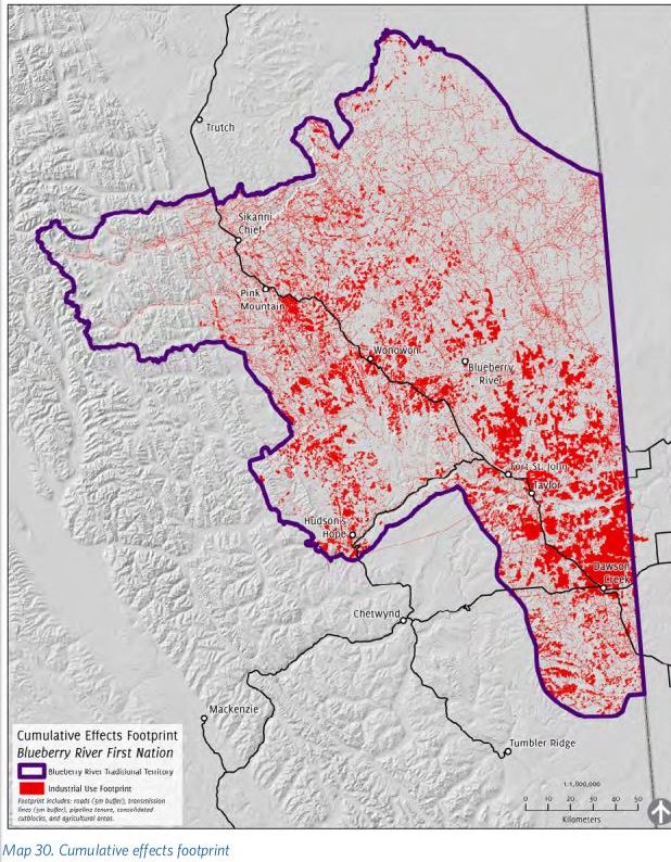
Using several industrial and infrastructure datasets, the data presented above was analyzed in order to determine disturbed areas in Blueberry River First Nations traditional territory.
For the footprint, roads (buffered from the centerline by 5 m, for a total width of 10 m), transmission lines (buffered from the centerline by 5 m, for 10 m total width), seismic lines (buffered from the centerline by 1 m, for 2 m total width), pipeline tenures, consolidated cutblocks and agricultural areas were used.65
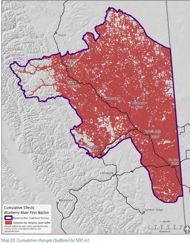
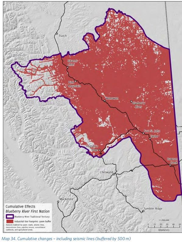
Since industrial activities have ecological effects beyond their actual footprint, the footprint datasets (roads, transmission lines, pipeline tenures, cutblocks, agricultural areas and seismic lines) were buffered by 250 m (Map 31) and 500 m (Map 32). The roads and seismic lines were buffered from the original centerlines, whereas the transmission lines were buffered from the width in the footprint (10 m). The other features are areas; the buffer is measured from their original extent.
Seismic lines were included in the analysis as they can have a significant impact on the landscape. However, an analysis was also included without them in order to make a comparison to Lee & Hanneman (2012), which did not include seismic data. The seismic data included in this analysis is used as publicly published by the government of British Columbia.
73% of the area inside Blueberry River First Nations traditional territory is within 250 metres of an industrial disturbance, and 84% is within 500 metres of an industrial disturbance. [Happy Rape Canada Day?]
64 Cumulative Effects Assessment Practitioners’ Guide: http://www.ceaa.gc.ca/default.asp?lang=En&n=43952694-1&toc=show&offset=6
65 The buffer for the roads was determined in conjunction with a Registered Professional Forester staff member at Ecotrust Canada (Satnam Manhas). Ten metres is considered the minimum amount of width a road will use. The width for transmission lines was determined by reviewing the width allowed in Crown Land tenure as well as the cleared area on satellite imagery. The buffer for seismic lines was determined based on the width column within the data. For the 2006-2016 dataset, the average width of the features is 2.3 m.
…
…
Summary of Findings
· 73% of the area inside Blueberry River First Nations traditional territory is within 250 metres of an industrial disturbance, and 84% is within 500 metres of an industrial disturbance.
· Blueberry River First Nations traditional territory totals 3,832,749 ha and contains 18
watershed groups.
· While 60% of British Columbia is considered intact forest landscape, Blueberry River First
Nations traditional territory has little intact forest landscape remaining – less than 14%.
· Provincial parks and protected areas make up less than 1% (0.713%) of Blueberry River First Nations traditional territory.
· The predominate LRMP zones are: General Resource Management (29.8%), Enhanced
Resource Development (28.4%), Agriculture/Settlement (22.6%) and Special Resource
Management (17.8%).
· Of the total area of B.C. reserved for pipelines via tenures, 46% falls within Blueberry River
First Nations traditional territory.
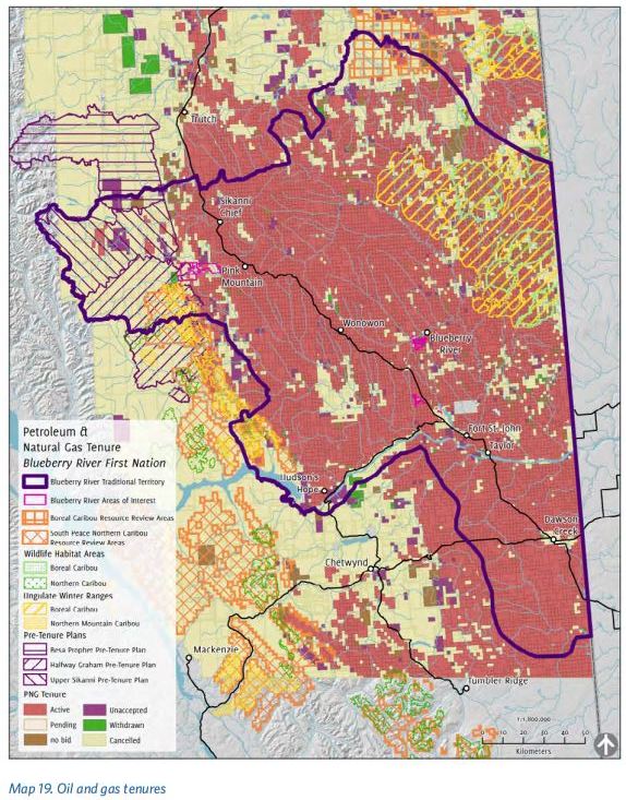
· Active petroleum and natural gas tenures cover 69% of Blueberry River First Nations
traditional territory.
· Including roads, transmission lines, seismic lines and pipelines, there are 110,300 km of linear features in 38,327 km2 of territory – or 2.88 km of linear disturbance per square kilometre. Significant portions of the territory have a linear disturbance density that is much higher (ranging from 6.1 to 12 km per km2) with other areas spiking over 24 km per km2 (see Map 6).
· The First Nation’s territory has 50,238 km of roads. Less than 4% of the roads are paved; 49% are rough and 45% are loose. Resource and unclassified roads account for 90% of the roads in the First Nation’s traditional territory.
· The total area of pipeline tenure in Blueberry River First Nations traditional territory is 27,918 ha. The total length of the pipeline tenure is approximately 13,979 km.
· From 2006 to 2016, 45,603 km of seismic lines have been recorded by the Oil and Gas
Commission in the First Nation’s traditional territory.
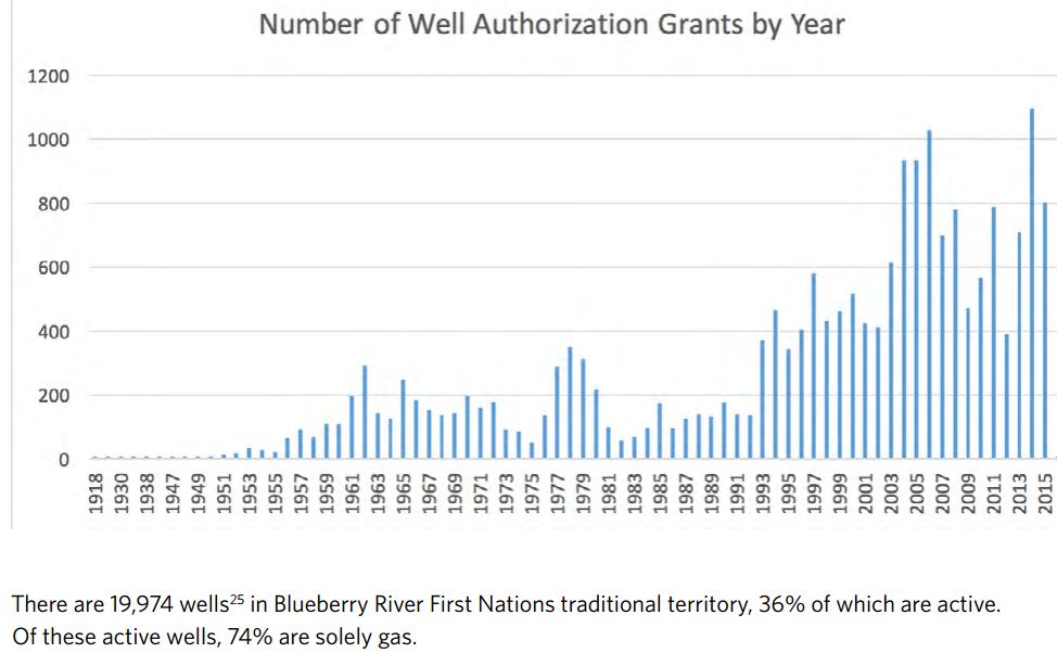
· Of the 19,974 oil and gas wells in Blueberry River First Nations traditional territory, 36% are active. There are 9,435 oil and gas facilities, primarily test facilities (6,210) and battery sites (1,120).
· The total percentage of land in B.C. that is set aside in the Agricultural Land Reserve is about 5%, whereas 28% of Blueberry River First Nations traditional territory falls within the ALR.
· Agricultural lands comprise 13% of Blueberry River First Nations traditional territory. Privately owned land now makes up 20% of the First Nation’s traditional territory.
· 195,091 ha of the First Nation’s traditional territory has been logged since 1950.
· Streams and rivers account for the most water volume withdrawn (28,100 m3
or 64%) in Blueberry River First Nations traditional territory.
· Two hydro dams, W.A.C. Bennett and Peace Canyon, lie within Blueberry River First Nations traditional territory, and construction on a third dam, Site C, is now underway. BC Hydro has identified 104 potential run-of-the-river developments in the First Nation’s traditional territory.
· The total length of BC Hydro Transmission Lines is 480.15 km in Blueberry River First Nations traditional territory.
· Mining tenures (61,377 ha) cover 2% of Blueberry River First Nations traditional territory. Coal tenures account for 96% of these tenures.
· There are 91,183 ha of wind power tenures in the First Nation’s traditional territory (2%). One operational wind farm along Bear Mountain contains 34 turbines. Two proposed wind farms are located in the First Nation’s traditional territory.
· Since January 1, 2013, the government of British Columbia has authorized construction in
Blueberry River First Nations traditional territory of more than 2,600 oil and gas wells, 1,884 km of petroleum access and permanent roads, 740 km of petroleum development roads, 1,500 km of new pipelines and 9,400 km of seismic lines. Also since that time, approximately 290 forestry cutblocks were harvested in the Nation’s traditional territory.
Conclusion
The data that is publicly available from government databases reveals that the landscape within the traditional territory of Blueberry River First Nations has undergone severe clearing and industrial disturbance. Whereas 60% of British Columbia is considered intact forest landscape, less than 14% of Blueberry River First Nations traditional territory is intact forest landscape. The diminishment and fragmentation of the natural landscape is consistent with the fact that less than 1% (0.713%) of the First Nation’s traditional territory is protected as a provincial park or protected area. Meanwhile, 46% of the total area of British Columbia that is reserved for pipelines as tenures is located in Blueberry River First Nations traditional territory. The First Nation’s territory is managed to meet the predominant Land and Resource Management Plan zones that have been established by the
government of British Columbia: General Resource Management (29.8% of the territory), Enhanced Resource Development (28.4% of the territory), Agriculture/Settlement (22.6% of the territory) and Special Resource Management (17.8% of the territory). Of the 50,238 km of roads that have been built in the First Nation’s traditional territory, less than 4% are paved, the other 96% being rough or loose roads, which is consistent with industrial uses, such as forestry and oil and gas activities.
There are 13,979 km of pipeline tenure in Blueberry River First Nations traditional territory and 19,974 wells in the territory, 36% of which are active. The First Nation’s traditional territory has 2,659,002 hectares of active petroleum and natural gas tenures. From 2006 to 2016, 45,603 km of seismic lines were recorded by the BC Oil and Gas Commission in Blueberry River First Nations traditional territory. Including roads, transmission lines, seismic lines and pipelines, there are 110,300 km of linear features in 38,327 km2
of territory – or 2.88 km of linear disturbance per square kilometre on average over
the whole territory. Significant portions of the territory have a linear disturbance density that is much higher (ranging from 6.1 to 12 km per km2) with other areas spiking over 24 km per km2 (see Map 6).
Additionally, two hydro dams, W.A.C. Bennett and Peace Canyon, are sited within Blueberry River First Nations traditional territory. Construction of Site C dam is underway, which will result in flooding of the Peace River valley and its tributaries, create an approximately 9,300 ha reservoir. BC Hydro has also identified 104 potential run-of-the-river developments in the First Nation’s territory.
Transmission lines (480.15 km in the First Nation’s traditional territory), wind power tenures (currently covering 2% of the territory, although not all are yet developed), water withdrawals (13,150,816 m3 from 2006 to 2015) and mining tenures (2% of the territory) are other cumulative impacts in the First Nation’s traditional territory.
Examining cumulative effects upon a landscape is inherently a multi-layered endeavor and no single snapshot can tell the whole truth at once. Numbers and maps are only two of the tools that can assist in gaining an understanding of the nature and scale of cumulative effects upon the traditional territory of Blueberry River First Nations. This understanding can only be crude, but it is a necessary starting point. The analysis in this Atlas, which is based upon government of British Columbia data, reveals that approximately 73% of the area inside Blueberry River First Nations traditional territory is within 250 metres of an industrial disturbance, and approximately 84% is within 500 metres of an industrial disturbance. [Emphasis added]
[It would be extremely valuable if regulators kept track of and mapped all locations where companies dump their drilling, cementing, servicing and frac waste, with volumes dumped including toxicity and radioactivity levels.
Imagine what Alberta would look like.]
[Refer also to: