Stunning cave images at link:
Oil drilling on sensitive New Mexico public lands puts drinking water, rare caves at risk, A National Geographic investigation has found that Permian Basin energy exploration could taint residential aquifers with pollutants—as well as Carlsbad Caverns and other cave systems.
Oil drilling on sensitive New Mexico public lands puts drinking water, rare caves at risk, A National Geographic investigation has found that Permian Basin energy exploration could taint residential aquifers with pollutants—as well as Carlsbad Caverns and other cave systems by Jennifer Oldham, Feb 3, 2021, National Geographic
At 4.3 miles long, Parks Ranch Cave in southeastern New Mexico is the second longest gypsum cave in the Western Hemisphere. The cave and its multiple branches are among 550 that crisscross a fragile, sinkhole-prone geologic region renowned for Carlsbad Caverns.
Standing in the inky depths of Parks Ranch, I cannot see my hands. The air is a comfortable 52 degrees Fahrenheit, 40 degrees cooler than the Chihuahuan Desert 30 feet above. The quiet is so complete, I want to bottle it and take it home with me to enjoy later. ![]() I used to have quiet like that in my home at Rosebud. Encana/Ovintiv’s frac’ing and endless compressors destroyed it, enabled by AER, including fraudulent data altering. Frac’ing brings on horrific noise, some of it 24/7, the worst always in winter and on cold spring, summer and fall nights and mornings, common on the high plains.
I used to have quiet like that in my home at Rosebud. Encana/Ovintiv’s frac’ing and endless compressors destroyed it, enabled by AER, including fraudulent data altering. Frac’ing brings on horrific noise, some of it 24/7, the worst always in winter and on cold spring, summer and fall nights and mornings, common on the high plains.![]()
We switch on our headlamps to illuminate scallop-shell-like indentations on the off-white walls, evidence of past rains that have flooded this well-known cave. It’s probably connected to at least several others, as well as many sinkholes, says my guide, retired U.S. Bureau of Land Management (BLM) cave and karst specialist James Goodbar.
This gallery and others like it in the region were formed by eons-long chemical processes that dissolved rocks from above and below. In their prehistoric stalagmites and stalactites, the caves hold pristine information on ancient climate. They also contain troves of well-preserved fossils, Native American artifacts, and organisms that could help in the search for new antibiotics. These tantalizing secrets, hidden in a limestone and gypsum landscape known as karst, lie above still more ancient riches: the country’s largest technically recoverable oil and gas reserves, in the Permian Basin of West Texas and southeastern New Mexico.
Now, the desert’s cave ecosystems and energy companies could be on a collision course. The Trump Administration, in pursuit of its “energy dominance” agenda, leased to oil and gas firms thousands of sinkhole-prone acres that most probably harbor caves. Some parcels are among the most geologically fragile ever offered for industrial use, which is why they hadn’t been leased yet. Little is understood about the fissure-ridden subterranean landscape that makes up the one-million-acre karst region, making it difficult to comprehend all that’s at stake.
A National Geographic investigation found that the Trump Administration’s push to open these public lands for energy exploration puts Carlsbad Caverns, scores of other caves in New Mexico, and aquifers that supply drinking water to tens of thousands of homeowners at risk of contamination.
What’s more, the threat to the region’s unique cave ecosystems and aquifers isn’t likely to recede during President Joe Biden’s administration.
As he promised during his campaign, Biden on January 27 paused new oil and natural gas leasing on federal lands, in order to undertake a “comprehensive review “of the nation’s fossil fuels program. The pause only affects new development, however. It does not stop companies from drilling on existing leases, and it allows agencies to continue to approve permits for additional drilling there.
Even before Biden delivered his promised moratorium, conservationists who consider it insufficient filed a lawsuit on January 21 seeking to overturn the Trump Administration’s sale of more than one million acres of public lands in the west for energy exploration, including acreage in southeastern New Mexico.
What the records show
An analysis of hundreds of pages of federal documents, protest letters, memos, and interviews with the BLM and energy companies showed that from 2017 to 2020 the BLM rented acreage in areas of New Mexico known for past drilling accidents.
• Several lease parcels lie just outside a cave protection zone north of Carlsbad Caverns National Park, in an area about which a park report had concluded, “if drilled, the risk of toxic and flammable contamination could potentially harm the unique cave environment.” Scientists are still mapping Lechuguilla Cave, known to be at least 150 miles long, and they suspect it may extend outside the protection zone.
• The BLM doesn’t always require detailed imaging that can predict where subterranean voids exist. Without such surveys, accidents occur. For example, a cavern opened under a drill rig near Black River Village Road about a half hour south of Carlsbad in the early 2000s, destroying nearby archaeological remains, and a 55-foot sinkhole swallowed a front-end loader near the Texas border. Firefighters rescued the driver.
• Some acreage auctioned to oil and gas companies contains caves with significant fossils, as well as rare bats whose populations haven’t been fully surveyed by federal biologists.
• Many leases issued in cave-prone areas stipulate that companies not drill “within 200 meters of known cave entrances,” or “significant karst features,” yet only two percent of the region is mapped for caves and karst, making it difficult for firms to know what’s there.
• An internal BLM study found there is a possibility that drilling fluids could contaminate water supplies. But the agency subsequently, in October 2020, leased acreage that would require companies to drill through an aquifer to reach oil and gas.
• The BLM noted in environmental reports that the region’s aquifers are uniquely susceptible to pollution from industrial activities, stating, “drilling fluids, produced saltwater, oil and/or gas, cuttings, and cement could quickly enter groundwater.”
The investigation also has discovered that the Trump Administration leased sensitive desert karst habitat held back by previous administrations. With over 80 percent of the land managed by the Carlsbad field office already leased to the energy industry, the move jeopardizes the last remaining refuges for threatened birds and reptiles, as well as migration corridors for pronghorn antelope.
Accelerated leasing also threatens to eclipse scientists’ efforts to understand how hundreds of caves intersect and act as the region’s plumbing system. Lack of knowledge about where caves are, coupled with the swiss-cheese-like geology, increases the possibility of an accident in which water sources or caves are contaminated, or Native American artifacts or fossils are destroyed. The gaps in knowledge also make it difficult to track a leak, or spill, and to know whom to notify downstream.
“The margin for error is narrower in karst areas,” says George Veni, a hydrogeologist and executive director of the National Cave and Karst Research Institute, a nonprofit government-supported institute created by Congress in 1998. “We need more time to gather data to better understand how the system works.”
The unknown
A few miles from Parks Ranch Cave, a frayed rope swing dangles from a cottonwood branch over the warm, crystal-clear Black River. Veni steps into the tree’s dappled shade for relief from the 92-degree heat and puzzles over an unsatisfying water-tracing experiment he’s conducting at the behest of the BLM.
He injected a small amount of bright green nontoxic dye into a rocky, shallow area downstream from the swing and watched it vanish into a hollow near some cottontail reeds. He hoped to trace the dye to nearby wells, but it hasn’t reappeared.
“It’s so frustrating,” says Veni, running his hand past his wire-rimmed glasses through a mop of curly gray hair grown shaggy during the pandemic.
“If I don’t find it, it will be the first project in which I didn’t find the dye,” he adds. “We really don’t know” what the flow rates are— how quickly water flows through the region’s complex and uncharted cave and karst drainage system. “These experiments are supposed to help tell us if this area needs to be better protected and managed.”
Veni added that occasionally dye isn’t found on the first try, given incomplete knowledge about the area’s karst geology. Unlike sandstone terrain that traps pollutants in its spongelike subsurface, karst landscapes do not filter water, allowing it to flow unimpeded through large conduits and channels directly into aquifers. So understanding how quickly and along what paths it flows is critical to being able to alert residents of danger when an oil and gas spill has occurred.
Accidents ahead?
Scientists might need more time and better data, but the dial is turning the other way. The BLM manages nearly 245 million acres of land, primarily in 12 western states. Its stated regulations require environmental reviews, collecting public comments, and addressing protests before auctioning parcels to the highest bidders.
After a 2017 executive order issued by Trump required the energy industry to be relieved of “regulatory burdens,” the BLM directed its field offices to greatly truncate environmental review and comment periods. The agency opened more than five million acres onshore to fossil fuel extraction between January 2017 and January 2020, compared with about 2.6 million acres auctioned off by the Obama Administration from 2014 to 2016.
… As oil and gas exploration expands, so does the number of accidents. According to a 1993 National Park Service report, companies had likely hit caves in the course of drilling at least 61 wells before then in the region around Carlsbad. Some of these accidents led to toxic fluids and oil and gas equipment entering voids. The Park Service concluded: “Substantial hydrocarbon reserves and known cave resources exist immediately north of the park boundary. It is probable that exploratory drilling will intersect openings that connect with caves in the park.”
During the past year alone, the BLM received eight reports of subsurface voids opening during seismic exploration and the construction of energy facilities. Those incidents occurred in places with no previously known sinkholes or caves. The agency also recorded 1,261 oil-and-gas-related spills in southeastern New Mexico in 2018. None of the incidents were reported as having affected groundwater, reports show. That doesn’t mean it hasn’t happened, says Goodbar, the retired BLM cave specialist, adding that land managers don’t know if contamination occurred unless they go in and do a groundwater study.
The risks of expanding industrial activity are evident below and above the surface. In October at the south end of the city of Carlsbad, I visit the ground above a cavity, created by a brine well used by energy companies, that’s one football field wide by two football fields long and as deep as two Santa Fe state capitols stacked. Part of the void, underground beneath the intersection of two highways, could collapse and become a sinkhole as early as this year, says Veni, and estimates put potential damages at $1 billion.
A line of quail scurries past me, navigating the lip of an irrigation ditch that also runs over the enormous hole hidden in the midst of their habitat. Increased oil and gas activity is eating up the region’s dwindling wildlife habitat, says Kelley Reid, a BLM wildlife biologist.
“There are no more prairie dogs on public land in the Carlsbad field office,” Reid says. “The heronries are disappearing or being abandoned. The diversity of wildlife is becoming homogenized and the species you really look forward to seeing are disappearing.”
Parks under threat
Untapped fossil fuels in southern New Mexico’s Permian Basin extend in part under federal land to the north and east of Carlsbad Caverns National Park. As energy exploration moved closer to it during Trump’s term, park Superintendent Doug Neighbor spent $450,000 on equipment to monitor degrading air quality and “impacts to our night sky,” emitted by flares burning natural gas off wells. ![]() Frac’ers’ endless compressors destroyed the night sky at Rosebud, an agonizing loss for me. Frac’ers don’t care. Politicians don’t care (bribes – aka donations – and elevating ego are cherished instead). Community leaders don’t care (bribes from frac’ers are lusted after instead). Regulators enable the pollution and endless frac harms, including to public health, to keep their paychecks intact. Doctors send you home if you dare mention your health concerns might be related to oil and gas. Hospitals refuse to admit oil and gas workers accidentally doused in frac chemicals and companies won’t let such workers use their emergency showers because then they’d have to spend money to decontaminate – they send chemical-drenched workers home to contaminate their vehicles, homes and families.
Frac’ers’ endless compressors destroyed the night sky at Rosebud, an agonizing loss for me. Frac’ers don’t care. Politicians don’t care (bribes – aka donations – and elevating ego are cherished instead). Community leaders don’t care (bribes from frac’ers are lusted after instead). Regulators enable the pollution and endless frac harms, including to public health, to keep their paychecks intact. Doctors send you home if you dare mention your health concerns might be related to oil and gas. Hospitals refuse to admit oil and gas workers accidentally doused in frac chemicals and companies won’t let such workers use their emergency showers because then they’d have to spend money to decontaminate – they send chemical-drenched workers home to contaminate their vehicles, homes and families.![]()
Neighbor, who warned in 2016 that the biodiverse park was at a tipping point as nitrogen emissions from oil and gas activity threatened native plants and wildlife, plans to use this data to buttress his comments on future lease sales. He told me that the BLM removed acreage near the park’s eastern boundary from a 2018 auction after he voiced concerns.
The 91-year-old park he runs is among a dozen, including Sequoia, Canyonlands, and Mesa Verde, imperiled by Trump’s energy policies, which could “fundamentally alter America’s landscape,” according to a report by the nonprofit National Parks Conservation Association. Leases acquired by oil and gas companies over the last four years on the doorsteps of national parks remain valid today, even as Biden seeks to curb energy exploration on public lands.
… In southeastern New Mexico, the BLM and energy companies say they take precautions before drilling to ensure that they don’t encounter caves or sinkholes that would risk an $8 million-per-well investment. The BLM says it analyzes parcels in high-karst terrain individually prior to leasing, and if there’s a risk of caves there, may require oil and gas companies to conduct field surveys for caves and karst before drilling and to move equipment away from fragile terrain.
If fissures in the ground indicate there may be caves, the BLM may further require imaging studies to map what is underground. They are expensive and time consuming. And even if scientists clear a parcel for drilling, without commissioning a study of what’s actually underground, they may miss something because the presence of subterranean passages wasn’t obvious on the surface, Goodbar says.
Such regulatory measures aren’t enough to reassure conservationists. Last August, the BLM sold leases on nine parcels, some within view of Carlsbad Caverns’ cliffside visitor’s center. One parcel may contain caves and definitely contains a migration corridor used by pronghorn antelope and mule deer, conservationists say. The acreage had been deferred from leasing during the Obama Administration.
On December 4, two conservation organizations, Audubon Southwest and New Mexico Wild, appealed to a federal review board to overturn the lease sale. The appeal says preventing development on the parcel could be among “the best (and maybe last) possible opportunity to protect some of the last remaining ecologically valuable land in the field office.”
Under the Trump Administration, the BLM was hoping to open more desert karst to energy exploration. In a draft management plan update, it proposed leasing 86,000 more acres, including land within view of the national park, in coming decades. A Department of Interior order on January 20 requires the BLM to put this revision on hold.
Decisions to be made
The desert region is now at a crossroads, with oil and gas activity planned on existing leases in much of its high-risk karst terrain, as well as in ecologically sensitive areas that biologists haven’t had a chance to fully survey. Habitat for the three-inch dunes sagebrush lizard, found only in the Permian Basin in southeastern New Mexico and west Texas, is imperiled by industrial activity, as are desert areas relied upon by the lesser prairie-chicken.
Goodbar’s nearly 40 years of experience at the BLM make him leery that even laws he helped write—including methods to help energy firms detect and avoid damage to geologic resources and rules that require them to stop work if they discover a significant cave and mitigate impacts to it—can keep fossil fuel companies in check. In 2018, before he left, the field office was asked to pare back expanded safeguards for cave and karst areas that he had drafted.
On a summerlike October day, Goodbar strides across a narrow ridge in the Mudgetts Wilderness Study Area, about 30 miles southwest of Carlsbad. He gestures across steep cactus-and-juniper-studded hillsides and says he’s worried that the BLM is stretched too thin to hold companies accountable for protecting karst. The agency has been understaffed regardless of who is in the White House, he adds. ![]() Understaffing (code name: Reduce red tape) is a popular technique used in Canada too, to ensure that oil and gas companies get to do what they want, where they want, no matter what the laws state.
Understaffing (code name: Reduce red tape) is a popular technique used in Canada too, to ensure that oil and gas companies get to do what they want, where they want, no matter what the laws state.![]()
“They need to slow down,” Goodbar says. “Let’s do this sensibly and not tear the land up so bad.”
On the valley floor below, just several hundred feet from a no-leasing zone that includes the wilderness area, the agency auctioned 2,481 acres in October 2020 for $41,123. The parcel is in a “critical karst area” near two caves. It includes rare plants and soils as well as a cobble-strewn flood plain.
Although the BLM would require energy companies to drill outside the flood plain, to reach the oil and gas they would need to drill through an aquifer that provides drinking water to Carlsbad residents as well as to farmers and ranchers nearby, Goodbar says. A BLM study he conducted in the area found there is a possibility for fluids used in drilling to contaminate groundwater if an accident occurred.
There are ways of reducing the risk, he says—cementing steel pipe into the borehole to prevent rock from collapsing, or performing pressure tests regularly to detect leaks—but not of eliminating it entirely. ![]() And then, there are companies like Encana/Ovintiv that intentionally perforate holes in that pipe and cement with which to then frac directly into community drinking water aquifers (Pavillion, Wyoming and Rosebud, Alberta), contaminating them, with regulators and police engaging in fraud and terrorism to help the company get away with it.
And then, there are companies like Encana/Ovintiv that intentionally perforate holes in that pipe and cement with which to then frac directly into community drinking water aquifers (Pavillion, Wyoming and Rosebud, Alberta), contaminating them, with regulators and police engaging in fraud and terrorism to help the company get away with it.![]()
Near Carlsbad Caverns’ eastern boundary, hydrocarbons from oil drilling were detected in water samples from Rattlesnake Springs, the park’s drinking water source, “during high-flow events, indicating some contamination may occur under certain conditions,” wrote Paul Burger, a park hydrologist, in 2016.
In the forehead-and-shin-bruising Parks Ranch Cave, which is itself imperiled by accelerated oil and gas activity nearby, Goodbar tells me he hopes to map how these outlets fit into the region’s natural underground plumbing. He’s also curious about rare lifeforms that may live here in a sensitive habitat about an hour-and-half drive southeast from the Mudgetts Wilderness Study Area.
“We discovered in cave systems north of here a new species of amphipod and a new species of beetle—there could be all kinds of new species here,” he says. “If there’s any change in these caves, in the constant humidity and temperature, the quiet and the dark, it could wipe out those species.”

Refer also to:
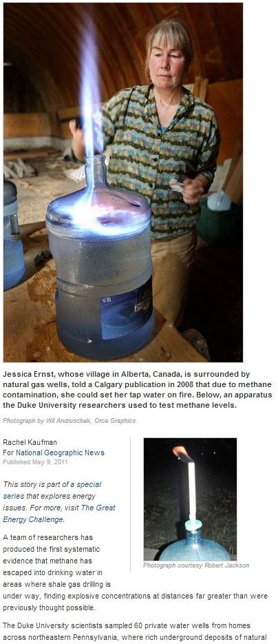
2011 05 09: National Geographic Methane on Tap: Study Links Pollution to Gas Drilling
Source: We are powershift.ca