Ecosystem services lost to oil and gas in North America, Net primary production reduced in crop and rangelands by Brady W. Allred , W. Kolby Smith, Dirac Twidwell, Julia H. Haggerty, Steven W. Running, David E. Naugle, and Samuel D. Fuhlendorf, April 24, 2015, Science
Advanced technologies in oil and gas extraction coupled with energy demand have encouraged an average of 50,000 new wells per year throughout central North America since 2000. Although similar to past trends (see the graph, this page), the space and infrastructure required for horizontal drilling and high-volume hydraulic fracturing are transforming millions of hectares of the Great Plains into industrialized landscapes, with drilling projected to continue (1, 2). Although this development brings economic benefits (3) and expectations of energy security, policy and regulation give little attention to trade-offs in the form of lost or degraded ecosystem services (4). It is the scale of this transformation that is important, as accumulating land degradation can result in continental impacts that are undetectable when focusing on any single region (5). With the impact of this transformation on natural systems and ecosystem services yet to be quantified at broad extents, decisions are being made with few data at hand (see the graph, this page).
We provide a first empirical analysis to advance beyond common rhetoric and speculation of oil and gas development (6), combining high-resolution satellite data of vegetation dynamics with industry data and publicly available data of historical and present-day oil and gas well locations for central North America. In addition to this broad-scale assessment of satellite-derived net primary production (NPP), a fundamental measure of a region’s ability to provide ecosystem services (7), we also evaluate patterns of land-use change and water use. Before this work, little has been done in examining these types of data and their relations with ecosystem services at broad scales.
ECOSYSTEM SERVICE TRADE-OFFS. NPP is the amount of carbon fixed by plants and accumulated as biomass. It is a fundamental and supporting ecosystem service that is the basis for all life on Earth (8). As such, the dynamics of NPP affect regional ability to provide a host of other essential ecosystem services (e.g., food production, biodiversity, wildlife habitat), which makes it a robust metric for broad evaluation of ecosystem services. Oil and gas activity reduces NPP through direct removal of vegetation to construct oil pads, roads, and so on.
These satellite-derived measurements of NPP began in 2000 and are produced annually; they capture interannual dynamics (9). To match the spatial scale of NPP measurement (∼1 km2), we determined annual density of oil and gas activity at the same resolution and estimated annual loss of NPP relative to such densities. Direct loss of vegetation resulting from oil and gas activity was validated at medium and fine spatial scales (∼250 m2 and 30 m2, respectively) by examining vegetation and disturbance trends before and after drilling [see supplementary materials (SM)]. We categorized annual reductions in NPP relative to land cover type (e.g., cropland and rangeland). As NPP is measured in grams of carbon per year, we convert to equivalent biomass-based measurements to provide context and discussion.

The number of oil and gas wells drilled within central provinces of Canada and central U.S. states 1900–2012. Canadian provinces: Alberta, Manitoba, and Saskatchewan. U.S. states: Colorado, Kansas, Montana, Nebraska, New Mexico, North Dakota, Oklahoma, South Dakota, Texas, Utah, and Wyoming. See SM.
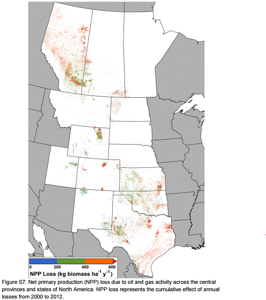
We estimate that vegetation removal by oil and gas development from 2000 to 2012 reduced NPP by ∼4.5 Tg of carbon or 10 Tg of dry biomass across central North America (see the chart on page 402, left). The total amount lost in rangelands is the equivalent of approximately five million animal unit months (AUM; the amount of forage required for one animal for 1 month), which is more than half of annual available grazing on public lands managed by the U.S. Bureau of Land Management (BLM). The amount of biomass lost in croplands is the equivalent of 120.2 million bushels of wheat, ∼6% of the wheat produced in 2013 within the region and 13% of the wheat exported by the United States (see SM for equivalency calculations).
The loss of NPP is likely long-lasting and potentially permanent, as recovery or reclamation of previously drilled land has not kept pace with accelerated drilling (SM). This is not surprising because current reclamation practices vary by land ownership and governing body, target only limited portions of the energy landscape, require substantial funding and implementation commitments, and are often not initiated until the end of life of a well (10). Barring changes from existing trends and practices, it is likely that NPP loss and its effects (i.e., further loss of forage) will continue to parallel drilling trends and, potentially, may create unforeseen conflicts among agriculture, conservation, and energy.
Additional ecosystem functions, including wildlife habitat and landscape connectivity, are arguably as important as NPP. We estimate that the land area occupied by well pads, roads, and storage facilities built from 2000 to 2012 is ∼3 million ha, the equivalent land area of three Yellowstone National Parks (see the chart, middle). Although small in comparison with the total land area of the continent, this important land use is not accounted for (11) and creates additional pressures for conserving rangelands and their ecosystem functions. The distribution of this land area has negative impacts: increasing fragmentation that can sever migratory pathways, alter wildlife behavior and mortality, and increase susceptibility to ecologically disruptive invasive species (6, 12). As competition for arable land intensifies because of food and bioenergy demand (13), oil and gas may further expand into native rangelands.

Cumulative impacts of oil and gas development on ecosystem services in central North America 2000–2012. (Left) Reduction in NPP (biomass), per land cover type. (Middle) Land area occupied, per land cover type. (Right) Number of wells in water-stressed regions (22). See SM.
The hydraulic fracturing technology underlying the current expansion of oil and gas drilling in the region has profound implications for hydrological, water-quality, and water-use regimes. High-volume hydraulic fracturing uses 8000 to 50,000 m3 of water per well for the initial fracturing event (14), which results in 7187 to 33,903 million m3for wells drilled across this region during 2000 to 2012 (see SM). Nearly half of wells drilled in this time period occurred in already highly or extremely water-stressed regions (see the chart, right). As refracturing becomes more common to yield greater production, oil and gas development adds to an already fraught competition among agriculture, aquatic ecosystems, and municipalities for water resources, in addition to concerns of water quality (15).
AVOIDING BROAD-SCALE LOSS. The capacity for insight into land-use decisions has improved substantially since the last major episode of widespread land-use change across the Great Plains. In the early 20th century, rapid agricultural expansion and widespread displacement of native vegetation reduced the resilience of the region to drought, ultimately contributing to the Dust Bowl of the 1930s. It took catastrophic disruption of livelihoods and economies to trigger policy reforms that addressed environmental and social risks of land-use change.
Fortunately, data and information are now far less of a barrier in understanding and addressing continental and cumulative impacts. However, the scale and focus of most land-use decision-making discourages comprehensive assessment of trade-offs implied in oil and gas development (16, 17). Recent planning efforts by U.S. federal management agencies demonstrate potential to balance demand for energy development with the need to protect other values (18, 19), but the scope is limited to lands under federal jurisdiction. About 90% of oil and gas infrastructure in this region occurs on private land (United States only; see SM). Provinces, states, and municipalities that permit the majority of oil and gas development lack the capacity and mandate to address continental or regional consequences that transcend political boundaries; this lack leads to fragmented and piecemeal policies (16, 20).
Decision-makers and scientists must work together to ensure that the best available information guides development of policies at the water-energy-food nexus (21). Traditional laws and regulations may have limited application, as oil and gas can be exempt from key environmental regulations (20), or such regulations isolate features of systems—e.g., a single species—while failing to capture interrelated impacts. Active synthesis and consolidation of data will improve accessibility and monitoring. Integration of these data into land-use planning and policy across scales and jurisdictions is necessary to achieve energy policies that minimize ecosystem service losses.
Supplementary Materials
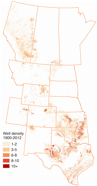
Figure S6. Oil and gas well density (wells km–2) for years 1900 to 2012.
Oil And Gas Drilling Is Consuming Millions Of Acres Of US Farmland: Study by Maria Gallucci, April 24 2015, International Business Times
As oil and gas drilling ramps up in the central U.S. and Canada, the region is losing an increasing amount of cropland, ranches and forests to industrial activities. In recent years, huge swaths of the Great Plains have given way to well sites, oil pads, parking lots and gravel roads that service the energy industry, researchers say.
… About 50,000 new wells on average have been drilled each year since 2000 in the central states and provinces, more than in previous decades. As a result, about 7 million acres of land was lost to energy development between 2000 and 2012, a study published Friday in the journal Science found.
“Although this [oil and gas] development brings economic benefits and expectations of energy security, policy and regulation give little attention to trade-offs in the form of lost or degraded ecosystem services” — a category that includes food production, biodiversity and wildlife habitat, according to the team of researchers from Midwestern and Western universities.
Roughly half the acreage lost over that 12-year period was rangeland. Another 40 percent was agricultural land and 10 percent was forests, while a tiny fraction of the total was wetland. Researchers estimated that the amount of crop production lost to drilling totaled 130 million bushels of wheat, or about 6 percent of the wheat produced in the region in 2013.
The research team assessed the effects of oil and gas development on crop production, land change and water use in 11 central U.S. states and three Canadian provinces. They combined high-resolution satellite data of vegetation with energy industry data and information about historical and present-day locations of oil and gas wells in the region.
“Before this work, little has been done in examining these types of data and their relations with ecosystem services at broad scales,” researchers wrote in the report.
Steve Running, one of the authors and a forest ecology professor at the University of Montana in Missoula, said the purpose of the study was not simply to point out that a large portion of land has been de-vegetated. Instead, researchers aimed to project how accelerated drilling could affect farms and ranches several decades into the future, Midwest Energy News reported. On average, the development of each new oil and gas well results in the clearing of 10 acres of vegetation, including grass, crops and trees.
“This is more about the accumulating effect through time of this pace of drilling if there is no active reclamation done on well areas after they have been depleted,” Running told the publication. [Emphasis added]