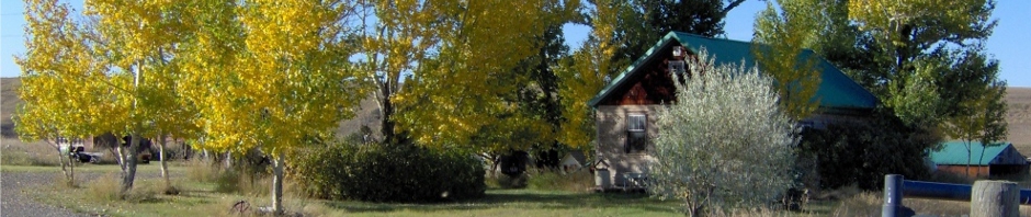
SkyTruth, the environment and the satellite revolution by Neely Tucker, July 31, updated August 1, 2013, Cover Story print edition August 4, 2013 Washington Post Sunday Magazine Skytruth, a small non-profit in Shepherdstown, West Virginia, is transforming the environmental movement with satellites. The Fold’s Zoeann Murphy zooms in for a look. Somewhere in the South Pacific, thousands of miles from the nearest landfall, there is a fishing ship. Let’s say you’re on it. Go onto the open deck, scream, jump around naked, fire a machine gun into the air — who will ever know? You are about as far from anyone as it is possible to be. But you know what you should do? You should look up and wave. Because 438 miles above you, moving at 17,000 miles per hour, a polar-orbiting satellite is taking your photograph. A man named John Amos is looking at you. He knows the name and size of your ship, how fast you’re moving and, perhaps, if you’re dangling a line in the water, what type of fish you’re catching. Sheesh, you’re thinking, Amos must be some sort of highly placed international official in maritime law. … Nah. He’s a 50-year-old geologist who heads a tiny nonprofit called SkyTruth in tiny Shepherdstown, W.Va., year-round population, 805. Amos is looking at these ships to monitor illegal fishing in Chilean waters. He’s doing it from a quiet, shaded street, populated mostly with old houses, where the main noises are (a) birds and (b) the occasional passing car. His office, in a one-story building, shares a toilet with a knitting shop. With a couple of clicks on the keyboard, Amos switches his view from the South Pacific to Tioga County, Pa., where SkyTruth is cataloguing, with a God’s-eye view, the number and size of fracking operations. Then it’s over to Appalachia for a 40-year history of what mountaintop-removal mining has wrought, all through aerial and satellite imagery, 59 counties covering four states. “You can track anything in the world from anywhere in the world,” Amos is saying, a smile coming into his voice. “That’s the real revolution.” Amos is, by many accounts, reshaping the postmodern environmental movement. He is among the first, if not the only, scientist to take the staggering array of satellite data that have accumulated over 40 years, turn it into maps with overlays of radar or aerial flyovers, then fan it out to environmental agencies, conservation nonprofit groups and grass-roots activists. This arms the little guys with the best data they’ve ever had to challenge oil, gas, mining and fishing corporations over how they’re changing the planet. His satellite analysis of the gulf oil spill in 2010, posted on SkyTruth’s Web site, almost single-handedly forced BP and the U.S. government to acknowledge that the spill was far worse than either was saying.
Refer to:
He was the first to document how many Appalachian mountains have been decapitated in mining operations (about 500) because no state or government organization had ever bothered to find out, and no one else had, either. His work was used in the Environmental Protection Agency’s rare decision to block a major new mine in West Virginia, a decision still working its way through the courts. “John’s work is absolutely cutting-edge,” says Kert Davies, research director of Greenpeace. “No one else in the nonprofit world is watching the horizon, looking for how to use satellite imagery and innovative new technology.” “I can’t think of anyone else who’s doing what John is,” says Peter Aengst, regional director for the Wilderness Society’s Northern Rockies office. Amos’s complex maps “visualize what can’t be seen with the human eye — the big-picture, long-term impact of environment damage,” says Linda Baker, executive director of the Upper Green River Alliance, an activist group in Wyoming that has used his work to illustrate the growth of oil drilling. … The world, and what we’ve done to it. Do we really want to look? Let’s go back to that fishing ship in the Pacific: How does Amos know so much about fishing ships, anyway? There — unidentified ships in the South Pacific, running without transponders — spotted from 5,000 miles away by a couple of guys looking at computer screens in a tiny office just a couple of blocks from the Blue Moon Cafe over on High Street. … “Oh, my God, look at that picture over there,” exclaimed mission commander Frank Borman. With a handheld camera, astronaut William Anders snapped a picture of Earth — a startlingly blue, startlingly delicate half-sphere — floating in a black void, above the pockmarked surface of the moon. Galen Rowell, the famed nature photographer, dubbed it “the most influential environmental photograph ever taken,” for it showed just how lost and alone we were in the cosmos. John Amos, growing up in Rochester, N.Y., remembers that photograph, for he grew up in a scientific household. … A few weeks ago, 45 years after “Earthrise” dazzled Amos and the rest of the world, NASA engineers in Greenbelt finished building a microwave radiometer that will go on a satellite next year. It will map soil moisture levels, taking 192 million samples per second, via a microwave beam that simultaneously filters out other microwave emissions, goes through vegetation, and gathers the “naturally emitted microwave signal that indicates the presence of moisture,” according to NASA. Armed with information about the dirt beneath our feet, those microwave beams will then ricochet to the satellite, then down to laboratories for analysis. This was scarcely reported upon. On the morning of April 21, 2010, Amos flicked on his home computer and saw that a BP oil rig had exploded overnight. He blogged about it, warning that the damage might be severe. Within a day, he was looking at satellite images: “SkyTruth analysis of two NASA satellite images taken hours apart yesterday suggests the Deepwater Horizon rig may have been drifting.” This was an editorial “we,” as Amos was SkyTruth’s only employee, but this would be his defining moment, and he was well prepared. After leaving home, he had gone to Cornell University, then to the University of Wyoming for a graduate degree in geology. He married his college flame, another outdoorsy New Yorker, Amy Mathews, and the couple settled in an Arlington bungalow. Amos was no environmental radical. He went to work for consulting firms that used satellite technology and remote sensing to search for oil and gas. It’s highly technical work. Ask him how to detect oil deposits in satellite pictures of rock formations, and he’ll pause and say: “pattern recognition.” His wife, a committed environmentalist for nonprofit groups, politely considered her husband to be working for the enemy. “I didn’t say anything,” she says now with a laugh. “John’s job paid, and we were a young couple that needed the paycheck. I didn’t want to dictate to him what was acceptable, but I could see it wasn’t satisfying to him.” As the years passed, Amos was, in fact, developing second thoughts. He says a “series of small epiphanies” led to his conviction, in the late 1990s, that he was aiding in the overconsumption of Earth’s resources. Given his family background, this was a serious moral issue. The decisive moment came when he came across a 1993 image of the Jonah oil field in Wyoming: sagebrush, grassland, cows, pronghorn antelope, a few gravel roads. He got a fresh image for a project he was working on. In just a few years, the gas wells — five-acre pads — had multiplied, as had the roads accessing the remote sites. “It had gone from ranchland to industry, just that fast,” he says.
Refer to:
Pollutants detected in water wells in Sublette County’s gas fields, many in Encana’s Jonah Field
Frackers Fund University Research That Proves Their Case
Deeply concerned that he had been using his talents in a “disservice to the planet,” he started SkyTruth in 2001. He had no clients, no resources and no fundraising experience. He worked on a throwaway desk in the couple’s unfinished basement with a space heater for warmth. He got one grant for $15,000 his first year, as seed money, and $16,000 his second year. The couple had decided not to have children, so the only risks they were facing were their own, but still: This was not a promising start. … Of course, a lot of people didn’t like his work, perhaps none more so than U.S. Sen. Mary Landrieu (D-La.), a staunch supporter of offshore drilling. When Amos finished testifying about the danger of such drilling before the U.S. Senate Committee on Energy and Natural Resources in November 2009, Landrieu mocked him repeatedly. At one point, she asked him to read a chart saying offshore drilling accounted for 1 percent of oil spills. When he said he was too far away to see it clearly, she said, voice dripping sarcasm, “Well. Let me try to read it for you.” After a few more gibes, she turned to lecturing. Offshore drilling, particularly conducted by rigorous American standards, she said, posed no realistic threat to the environment. She said he was trying to frighten people with misleading satellite photographs. “You do a great disservice — you and your organization — in not telling the American people the truth about what happens in domestic drilling, on shore and off, and putting it in the perspective that it deserves,” she said. Five months later, in April 2010, Amos was looking at the BP oil spill, 41 miles off the coast of Landrieu’s state. It was doing something Landrieu had said couldn’t happen to an American-run well: spew out of control. The oil slick spread to 817 square miles, then to 2,223, he could see from NASA satellite images. Given that range, Amos reasoned, the BP and the Coast Guard official estimates of 1,000 barrels per day couldn’t be right. Oil is lighter than water, so most of it floats to the surface and spreads out in layers just microns thick. But to reflect enough light to be seen from above, it has to be a certain thickness, giving rise to established formulas about the size of spills. Amos and Ian MacDonald, a friend and an oceanographer at Florida State University, figured that the spill had to be at least 5,000 barrels per day, and perhaps many times higher, depending on the size of underwater plumes. On April 27, Amos blogged: “Based on SkyTruth’s latest satellite observations today of the size of the oil slick and published data on the thickness of floating oil at sea that produces a visible sheen (1 micron, or 0.000001 meters) we think the official estimate of the spill rate from the damaged well has been significantly too low.” He went on to catalogue his computations with MacDonald, concluding that the spill had to be at least 6 million gallons — about half the size of the Exxon Valdez spill, then the worst in American history — and was now gushing at 20 times the rate that BP and the Coast Guard reported. By May 1, the pair was saying the spill had passed 11 million gallons. Their report was picked up by environmental groups and news organizations. The federal government immediately upped its estimate to 5,000 barrels per day. The blog went viral. Amos became a hot television news property. He was quoted in The Washington Post, the New York Times and dozens of others.
Refer to:
BP Oil Spill Criminal Investigation May Ensnare Executives In Cover-Up
On April 25, 2010, three days after the Deepwater Horizon rig sank in the Gulf of Mexico, Doug Suttles, a senior BP executive [now Encana CEO that replaced suddenly-out-the-door Randy Eresman: Down goes Encana’s Eresman! Natural gas giant’s president and CEO abruptly announces his retirement], told reporters the company’s deep-sea well was leaking about 1,000 barrels of oil a day, a fraction of its maximum output. “This is a long way away from something more significant,” Suttles said.
… Legal experts said criminal convictions for covering up the size of the spill could land senior BP personnel behind bars and swell the company’s civil liability by billions of dollars.
… “I’d be shocked if there weren’t more arrests and charges, against people significantly higher up the food chain than Mix,” said Dan Cogdell, a Houston criminal defense attorney specializing in white collar and environmental cases. … Lawyers for one of BP’s corporate partners on the Macondo well also have concluded that more individuals at the British oil giant may be indicted for covering up the true extent of the spill, according to a senior consultant for the firm, who requested anonymity due to the sensitivity of the investigation. Prosecutors may be targeting BP executives for withholding information about the company’s internal flow-rate models with the government, said the consultant, who has discussed the matter with attorneys directly involved with civil and criminal litigation over the spill. “Other BP people are going to be indicted,” he said. “They’re going after them on the flow rate.” “They’re going to try to get some of the big boys,” he added.
… An attorney for Suttles did not respond to a request for comment. According to DeGuerin, the defense attorney, government prosecutors do not need to show that BP officials lied to the federal government about the extent of the spill to win a criminal conviction. Any attempt to conceal the truth could result in a guilty verdict, he said. “A dodge, an evasion, a coloring of the facts, is as bad as an outright lie,” [Emphasis added]
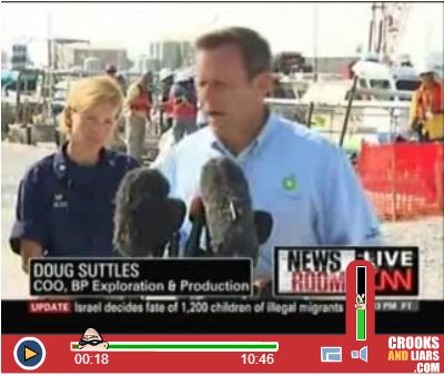
Doug Suttles joined Encana as President & CEO in June 2013

Source: Encana website
Spill Cam, the unofficial name for the company’s video of oil gushing out of the underwater ruptured pipe, transfixed the nation. The government’s new spill-rate estimate was quickly questioned by the news media, dismissed as too low, with MacDonald and Amos being quoted as the more reliable experts. The Coast Guard gave up, saying exact estimates were “probably impossible.” A BP official said, in May, “there’s just no way to measure it.” But MacDonald and Amos were pretty accurately estimating the spill, co-writing a New York Times op-ed piece late in the month that argued that such estimates were vital to cleanup and restoration. Landrieu, talking to National Public Radio’s Scott Simon, in June, eight months after she had ridiculed Amos, sounded much different. “BP made some terrible judgments about how this should — well, should have been operated, closed, you know, brought online — terrible judgments.” Her Web site credits her with playing a leading role in legislation that directed “80 percent of the Clean Water Act penalties paid by BP directly to the Gulf Coast.” When her public affairs staff members were asked recently if the senator had changed her mind about SkyTruth, they responded with a statement from Landrieu saying that she thought BP should pay for the spill. It did not address SkyTruth. When asked again about SkyTruth, they did not respond. The size of the spill is still being fought out in court. But it’s at least 172 million gallons. SkyTruth had broken through. On a recent morning in Shepherdstown, Paul Woods, SkyTruth’s new chief technology officer, is working with two interns on maps that will detail fracking operations in Tioga County, Pa. He’s also on a Skype call with Egil Moeller, a computer programmer in Gothenburg, Sweden, whom they’ve hired to build a crowdsourcing Web site. The idea is to give volunteers a short online tutorial, then have them make simple classifications (active, not-active, etc.) about each drill site, based on aerial and satellite imagery. This will help build county and statewide maps of the reported 3,600 Pennsylvania fracking operations. Woods says there are “gaps in the state data” that make it unclear if some permits were ever drilled, or if some drill sites actually used the high-pressure water blasting techniques that have made fracking so controversial.
“We want to play Tom Sawyer, to get the whitewash and the fence, and then get people to do the rest of the work, looking at their own patch of the planet.” John Amos
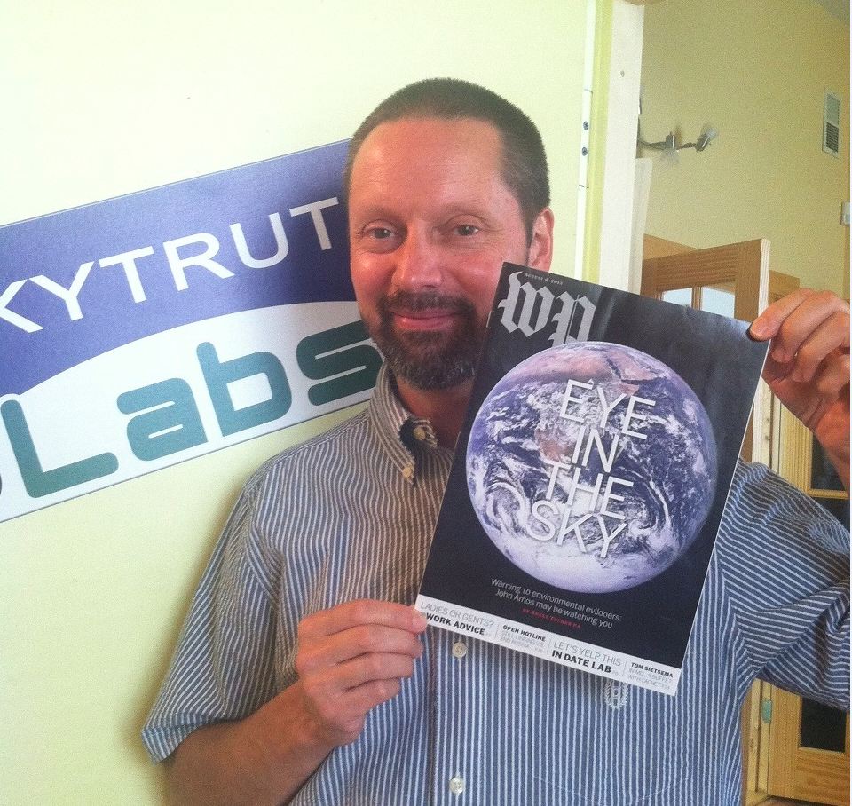
50-year-old geologist John Amos, who created and heads SkyTruth
… SkyTruth is no longer a one-man show, and it’s no longer quite so tiny. Annual donations and grants had averaged about $75,000 per year before the gulf oil spill, but are now at $405,000. There are four full-time employees, two paid interns. … On the ground, it’s impossible to understand the scale of the practice. But up in the air — the SkyTruth view of life on Earth — the scabs go on and on. Scab here, scab there, then another and another, breaking up the green expanses, going to the horizon and beyond. Even the “reclaimed sites,” the used-up mines, are dull brown, lakes of dirt with little sprinkles of green, the grass struggling to grow. This is the world we’ve built for ourselves — the modern world runs on hydrocarbons — but you have to wonder, floating in a little metal box thousands of feet in the air, if this is the kind of truth we want to leave behind as our mark on Earth, as our scratchmark, as Faulkner had it, on the face of oblivion. [Emphasis added]