“I cannot stress enough that the conditions we are facing right now are conditions that we have never seen before.”
— Cliff Chapman, BC Wildfire Service
Okanagan fires offer a glimpse of a worsening wildfire crisis by Jeffrey Jones and Sara Mojtehedzadeh, Aug 9, 2026, The Globe and Mail
To the thousands forced to flee their homes in British Columbia’s normally idyllic Okanagan Valley, the wildfire that quickly consumed large tracts of the area this weekend was a regional disaster.
But to John Vaillant, who has studied the connections between fire and climate change extensively, the blaze is one piece of a much larger crisis that this year has enveloped large parts of Canada, the United States, Spain, France and Greece, and is worsening.
Severe drought and more frequent heat waves are hemispheric in scale, and the evacuated B.C. towns of Summerland and Peachland are just the latest to experience the conditions that produce fast-expanding infernos, said Mr. Vaillant, who authored the 2023 book Fire Weather: A True Story from a Hotter World.

He pointed to the inferno sweeping through the Spokane, Wash., area, which has forced the evacuation of more than 60,000 people and destroyed nearly 1,000 homes, as another in a rash of flare-ups made worse by rising concentrations of greenhouse gases caused by the burning of fossil fuels.
“They’re outliers maybe in terms of geography, but they’re not outliers in terms of what’s happening,” he said in an interview.
The Bald Range wildfire near Summerland has burned more than 135 square kilometres, forcing the evacuation of as many as 20,000 people and prompting the provincial government to declare a state of emergency. The RCMP said it was investigating a possible death related to the fire, which the province said had caused “significant structure loss.”
B.C. wildfires: What is a state of emergency?
The Okanagan Valley, a vacation hot spot known for its lush vineyards and orchards, has dealt with drought for the past three years. This spring, Okanagan Lake received just a third of its normal “recharge” in the forms of snowmelt, streams and rainfall, according to the Okanagan Basin Water Board.
There’s a universal recipe for wildfires, regardless of their location: Dry vegetation for fuel; lightning or a human-caused source of ignition; and hot, dry, windy weather, said Dr. Mike Flannigan, professor of wildland fire at Thompson Rivers University in Kamloops, B.C. All converged to form the blaze in the Okanagan, he said.
That potent combination is reality for much of the heavily-forested province. Statistics show that the top six years for the area burned in the province annually have been since 2017, and more area has burned in that nine-year period than between 1950 and 2016.
“So it’s been a dramatic increase in fire, and I attribute this to climate change. I can’t be any more direct: The warmer we get the more fire we see,” Dr. Flannigan said.
Given the conditions and forecasts for more hot weather, wildfires could ravage the province into September and beyond, he predicted.
The Okanagan fire follows a now-familiar pattern. Over the past decade, wildfires have become larger and more destructive. They have ripped through Fort McMurray and Jasper, Alberta; Lytton and West Kelowna, B.C.; as well as several First Nations across the country. And Slave Lake and Waterton
Fires played major roles in record years for financial losses caused by weather-related disasters. Insured losses across the country hit a record high with $9.4-billion in 2024, when Jasper burned, followed by $6.5-billion in 2016, when large parts of Fort McMurray, were destroyed and more than 80,000 people were forced to flee.
Opinion: How we created a devastating fire debt
The main culprit is changing weather as global greenhouse gas emissions climb despite international commitments to curb them. In Canada, it means higher average temperatures, thinner snowpack and drier conditions in heavily forested regions, according to the Canadian Climate Institute. Fires can help forests to regenerate themselves naturally, but they are becoming far more damaging as they burn hotter and consume forests quicker, it said.
Mr. Vaillant said that more fires globally are becoming so intense as to generate their own thunderstorm clouds, known as pyrocumulonimbus, which can produce lightning.
Some of the Okanagan region’s active fires, such as the one in La Casa, near Vernon, B.C., have ignited on burn scars from past wildfires – which should be unsurprising to policy-makers, said B.C.-based fire ecologist Robert W. Gray.
Without regular prescribed burns, which are crucial to reducing fuel loads in grassland ecosystems like the Okanagan, wildfires will keep igniting in scarred areas, said Mr. Gray, a four-decade veteran of fire management across North America.
The Okanagan’s native landscape under Indigenous fire stewardship would have, at one time, resembled “a mangy dog,” said Mr. Gray, with clumps of mature trees, burned areas with grass regrowth, wet meadows and aspen groves acting as natural fire deterrents.
Today, that rich ecosystem is all but gone due to fire exclusion, he said, referring to the practice of repressing natural or cultural fires that help regenerate grasslands. The area is now heavily populated with Douglas fir and lodgepole pine – tree species that are not particularly fire-tolerant and crowd out other growth.
The devastation in the Okanagan feels shocking, said Mr. Gray, who could see the Bald Range fire pulsing from his cottage about 30 km away.
But the time has come to “strap ourselves in,” he said. “This is what’s coming.”
As a result, resilience has to be top priority, experts say. Local solutions such as prescribed burns and growing native, fire-resistant vegetation are all part of rebuilding nature’s “speed bumps” to slow wildfire spread, Mr. Gray said.
Canada wildfire maps: Where and how many are currently burning
Builders and homeowners should follow actions recommended by the national FireSmart Canada program, including constructing with fire-resistant materials and keeping vegetation away from homes, Dr. Flannigan said.
Still, these measures alone won’t halt the fires, some of which are caused by flying embers. Dr. Flannigan is calling for additional money, full-time personnel and resources directed toward firefighting, perhaps within a national disaster relief system. Resources to battle blazes could be put in place pro-actively, based on fire predictions, he said.
Carney cut funding for fire fighting, so did Danielle Smith, and other greedy premiers, wanting all the money they can take from the public, to give to their billionaire oil and gas pals who are frac’ing masses of our water away, permanently, FFS. Carney won’t give a penny, as he gives more and more and more of our money to Nazi Trump’s demand for stupid water guzzling wetland destroying stolen AI, military, and his rich friends.
For Mr. Vaillant, the ultimate answer is public policy that accelerates the shift away from fossil fuels. With their support of a new oil pipeline to the West Coast, the federal and Alberta governments are only contributing to the wildfire problem, he said.
“e said. “Summerland is a famous town out here. It’s a beautiful place and everyone’s been evacuated and it’s burning. We have to start thinking systemically and start to see the pattern, and then we have to govern.”
The U.S. just had its hottest month in recorded history, surpassing Dust Bowl record
NASA aircraft flies high over B.C. wildfires to study pyrocumulonimbus clouds
NASA flies over wildfires
The Canadian Press – Aug 10, 2026, Castanet

NASA’s ER-2 Earth Resources aircraft is shown in this undated handout photo. THE CANADIAN PRESS/Handout — NASA (Mandatory Credit)
A high-altitude research aircraft from NASA flew over British Columbia’s wildfires over the weekend in a bid to better understand weather events generated by large blazes.
Online aviation tracking shows the ER-2 plane flew back and forth over B.C.’s southern Interior more than a dozen times on Saturday on a flight of more than six hours that took off from Great Falls, Mont.
Data from the Flightradar24 website shows the plane spent about four hours at an altitude of 60,000 feet over the Clinton area, where the massive Pear Lake wildfire has been burning,
It also swung east over Lake Revelstoke before returning to U.S. airspace.
NASA says on its website that the ER-2 is researching pyrocumulonimbus clouds, which it describes as “one of the least understood forms of severe weather on Earth.”
The BC Wildfire Service says the Pear Lake wildfire, the largest in B.C. at almost 1,500 square kilometres, has created such clouds that are formed by extreme smoke and heat and can in turn generate rain, lightning and fire tornadoes.
The ER-2 is a repurposed Cold War spy plane known as the U-2, that has set records for extreme altitude flights up to twice as high as the typical altitude of commercial flights.
NASA says the aircraft is fitted with “state-of-the-art infrared wildfire trackers” to register data on pyrocumulonimbus clouds.
“Smoky and crackling with lightning, these unique storms can create blind spots for aviators above and spark new blazes below,” NASA says in a news release.
“Measuring and mapping the dangerous storms as they develop in real-time will help scientists forecast them in the future.”
@fayadmulla.bsky.social:
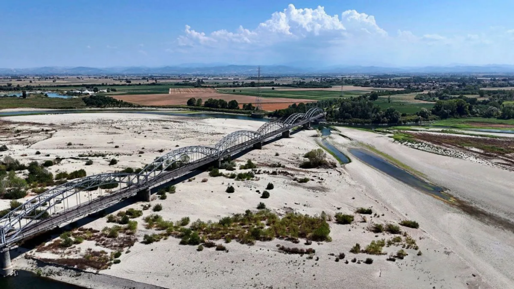
Der Po, Italiens größter Fluss.The Po, Italy’s largest river (August 2026).
Refer also to:
A proportion (25% to 100%) of the water used in hydraulic fracturing is not recovered, and consequently this water is lost permanently to re-use, which differs from some other water uses in which water can be recovered and processed for re-use.
2026: New research: Wildfires harm fish, causing devastating impacts during and after fires, some lasting many years. Over the last decade, land burned in Canada and many other parts of the world has increased, resulting in more socially and economically disastrous wildfires. The Canadian situation will worsen as human pollution continues to escalate making the climate hotter, increasing drying of soils and forests. And still cruel humans frac.
Don’t forget humanity’s ultra greedy and stupid plantation forests of only the most flammable trees, re money, then more greedily and stupidly, heavily spraying them with glyphosate to kill all deciduous trees and shrubs which can stop or slow fire