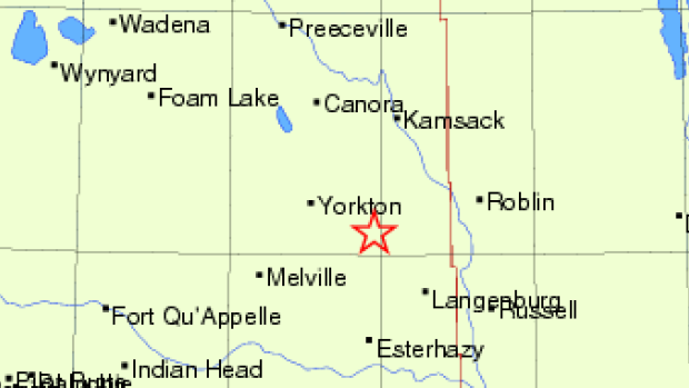
Natural Resources Canada changed the 3.8M Saskatchewan earthquake location from southeast of Yorkton to east of Esterhazy. The reported story tone changes a bit, does not mention Yorkton or explain why the location changed.
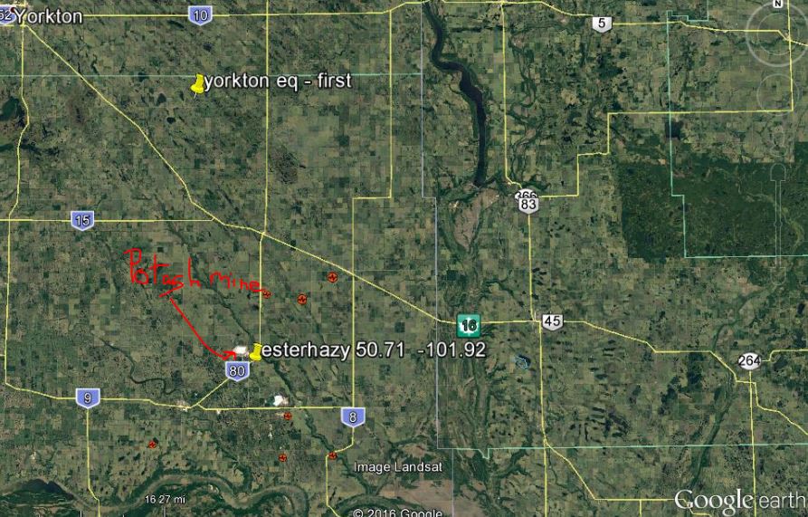
Yellow push pins with white font in map above show locations of where the 3.8M was reported, first southeast of Yorkton, then, east of Esterhazy. The potash mine is the white spot next to the Esterhazy marker.
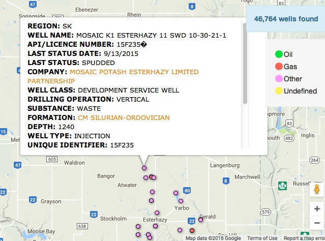
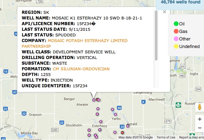
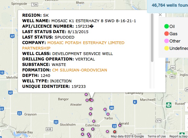
There are numerous injection wells in the area:
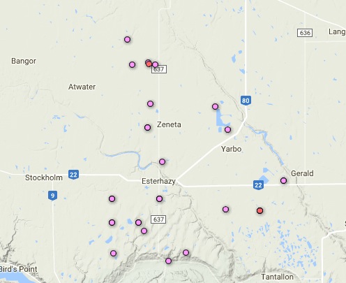
Pink are injection wells.
‘My trailer was starting to shake’: Esterhazy, Sask. residents describe 3.8 magnitude earthquake by Christa Dao, September 6, 2016, Global News
Long-time resident Charlene Hershmiller said her trailer started shaking when a 3.8 magnitude earthquake struck 13 kilometres east of Esterhazy, Sask.
“It shook the whole trailer. It shook my bed, shook my deck,” Hershmiller remembered.
She lives in a trailer in town and said the earthquake shook her awake.
“I could hear my plates rattling,” she said.
According to Natural Resources Canada, the quake happened Monday at 4:40 a.m. CT. Over 20 felt-reports were filed through the website, ranging from weak to moderate shaking.
Lacey Moore also lives in Esterhazy. She said she’s experienced quite a few earthquakes living in the area.
“The tremors happen quite often. This one was maybe bigger than usual,” Moore said.
Moore said the shaking forced her awake, and what was just seconds felt much longer.
“It seems long when you’re going through it,” she described.
According to Natural Resources Canada, the epicentre of the earthquake was 13 kilometres east of the town.
Around Esterhazy, some residents pointed to the nearby Mosaic potash mine as being the trigger and cause of Monday’s quake.
According to seismologist Dr. Honn Kao of the Geological Survey of Canada, he doesn’t think the activity in the region is responsible for Monday’s earthquake.
“The magnitude of this size, 3.8 will require accumulation of tectonic stress. Man-made activity will not cause this kind of magnitude event unless it’s nuclear explosion which I definitely don’t think is the case here,” Kao explained. [Mr, Kao gets paid to provide such false information to the public? As of September 11, there was no correction reported by Global]
[Frac Quake Reality Checks:
However, Kao said in the past, earthquakes have been linked to mining and fracking.
“Some of them have been linked to the potash mining activity in the area and we also know for certain that the region, especially in the epicentre region, has potash mines around and therefore it is possible that [earthquakes in the area] can be linked to that,” Kao said.
Regarding Monday’s event, he said further investigation and research is required, and with information from local mining authorities to determine what exactly happened. [Emphasis added]
2012 earthquake felt near Esterhazy by riderfans discussion group, 2012
Potash miners briefly trapped underground after earthquake shakes Saskatchewan by The Canadian Press, September 7, 2016, Calgary Herald
ROCANVILLE, Sask. — Some people were shaken awake and some miners stuck underground in southeast Saskatchewan when a magnitude 3.8 earthquake hit early Monday morning.
Earthquakes Canada said it happened around 4:40 a.m., and was centred about 32 kilometres east-southeast of Yorkton.
The Potash Corp. mine near Rocanville, Sask., had to switch to backup power when a power outage occurred.
However, that wasn’t enough to run the hoists so about 40 people were stuck underground for a while.
Randy Burton of Potash Corp. said the people underground went to refuge stations with power, air, and water until the power came back on.
The workers were then slowly brought back up to the surface — the last person coming up at about 11:30 a.m.
The company hasn’t sent crews back down since, but it’s not because of the outage.
“We’re just starting our annual maintenance shut down, so this happened just by coincidence at the same time,” said Burton.
Everyone was alright after the incident, and Burton said there was no damage to the mine.
SaskPower reported a widespread outage in the area that impacted Moosomin, Rocanville, Whitewood, Esterhazy, Stockholm and Wapella. The company said the quake caused problems at a switching station, taking out power to about 2,000 residential customers.
This isn’t the first time an earthquake has been felt in the area. According to Natural Resources Canada, there have been 12 earthquakes in the region at magnitude 3.0 or higher since 1981. [Emphasis added]
3.8 magnitude earthquake hits southeast of Yorkton, Sask by Christa Dao, September 5, 2016, Global News
According to Earthquakes Canada, a minor earthquake was detected in southeastern Saskatchewan, approximately 32 kilometres southeast of Yorkton.
The 3.8 magnitude quake happened early Monday at 4:40 a.m. CT.
READ MORE: Earthquake shakes swath of Midwest from Nebraska to Texas
According to seismologist Dr. Honn Kao with the Geological Survey of Canada, close to a dozen people reported feeling the quake, but there were no reports of significant damage or injuries.
“A magnitude 3.8 earthquake is considered to be a small event,” he said.
“However, it was definitely felt by the local community.”
The seismologist explained that this particular earthquake occurred in a place that is considered to be relatively seismically inactive, compared to the West Coast, which is said to have the highest seismic risk.
“The Prairie area is considered to be much less in terms of seismic activity, nevertheless this particular region has historically had some events,” Kao said.
“None of the events were big and this particular earthquake is consistent with that pattern.”
Despite inactive seismic activity, Kao explained the area is not immune to earthquakes.
“We had historically quite a number of earthquakes in that general area so it’s not a total surprise to us that we actually observed an earthquake in that region this morning,” he said.
There have been 11 similarly sized earthquakes in the same region since 1981, according to Natural Resources Canada.
Kao explained earthquakes are caused by tectonic stress accumulation. He said it is difficult to point out exactly what the cause was, but said generally speaking, tectonic stress accumulation is the ultimate cause of earthquakes in the region.
“Earthquakes are caused by sleep motion along faults. In general, if you have a place where you have accumulated tectonic stress, then you can have earthquakes occurred along faults.”
A number of communities in the region experienced a power outage between 4:40 and 6:30 a.m.
SaskPower has confirmed the outage was due to the quake.
“An earthquake in the Yorkton region… [resulted] in a power outage to customers served by the Tantallon substation,” SaskPower spokesperson Heather Johnson said.
Affected areas included Esterhazy, Gerald, Stockholm, Wapella, Fairlight, Flemming, Red Jacket, Welwyn, Ryerson areas, as well as feeds into the Melville district which include Stockholm, Grayson, Debuke and surrounding areas. [Emphasis added]
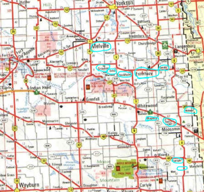
Turquoise circles show communities affected by the power outage caused by the 3.8M earthquake
Map from: Saskatchewan – Weyburn Sector Map
Early-morning earthquake shakes Yorkton, Sask., area, No damage reported in 3.8 magnitude quake by CBC News, September 05, 2016
Natural Resources Canada says there was a small earthquake centred southeast of Yorkton, Sask., at 4:40 a.m. CST on Monday. (Natural Resources Canada )
A light earthquake was felt this morning in the Saskatchewan communities of Yorkton, Melville and Langenburg, Natural Resources Canada has reported.
Officials confirm there was a 3.8 magnitude quake centred southeast of Yorkton at 4:40 a.m. CST.
At least one person reported feeling light shaking, but there were no immediate reports of damage.
Natural Resources Canada would like to hear from residents who felt shaking, and reports can be filed here.
SaskPower said the earthquake affected an electrical substation, impacting rural customers in the Esterhazy and Melville regions. Power was restored by 6:30 a.m., but crews remain at the substation to make sure it is ready to go back online.
Not the first time
This is not the first time an earthquake has rattled the region, located about 200 kilometres northeast of Regina.
There have been five others of a similar magnitude in the Yorkton-Esterhazy area in the past 16 years, and 11 since 1981.
“The last one that we recorded was in 2014. It was a 3.1. The time before that was July 8 — 3.7 — in 2013,” said Michal Kolaj, a seismologist for Natural Resources Canada. “Earthquakes in general occur if you have a slip along a fault.”
Kolaj said an investigation into the quake will take place over the next few days to try and determine whether it is consistent with a natural event or whether it’s linked to some sort of human activity.
“We’ll look to see whether the location is in close proximity to active mining or other types of anthropogenic activity. [Fracking the Bakken?] And then we’ll maybe seek to also contact the companies themselves to gather some more information.”
[Emphasis added]
[Refer also to: